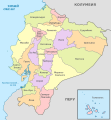
File:Ecuador, administrative divisions - ru - colored.svg

Original file (SVG file, nominally 1,535 × 1,654 pixels, file size: 1,017 KB)
Captions
Captions
Summary
[edit]
| This is a retouched picture, which means that it has been digitally altered from its original version. The original can be viewed here: Ecuador, administrative divisions - de - colored.svg:
|
Licensing
[edit]
|
Permission is granted to copy, distribute and/or modify this document under the terms of the GNU Free Documentation License, Version 1.2 only as published by the Free Software Foundation; with no Invariant Sections, no Front-Cover Texts, and no Back-Cover Texts. A copy of the license is included in the section entitled GNU Free Documentation License. | 1.2 onlyhttp://www.gnu.org/licenses/old-licenses/fdl-1.2.htmlGFDL 1.2GNU Free Documentation License 1.2truetrue |
Original upload log
[edit]This image is a derivative work of the following images:
- File:Ecuador,_administrative_divisions_-_de_-_colored.svg licensed with GFDL-1.2
- 2012-10-15T22:10:00Z TUBS 1535x1654 (748026 Bytes) == {{int:filedesc}} == {{Information |Description={{de|Karte der politischen Gliederung von XY (siehe Dateiname)}} {{en|Map of administrative divisions of XY (see filename)}} |Source={{own}}{{Adobe Illustrator}}{{Commonist}}
Uploaded with derivativeFX
File history
Click on a date/time to view the file as it appeared at that time.
| Date/Time | Thumbnail | Dimensions | User | Comment | |
|---|---|---|---|---|---|
| current | 06:47, 12 August 2013 |  | 1,535 × 1,654 (1,017 KB) | Alex Great (talk | contribs) | Now colors is changed. |
| 06:43, 12 August 2013 |  | 1,535 × 1,654 (1,012 KB) | Alex Great (talk | contribs) | Colors of disputed areas between Esmeraldas and Imbabura changed from green and yellow to green and orange. | |
| 06:09, 12 August 2013 |  | 1,535 × 1,654 (1,017 KB) | Alex Great (talk | contribs) | Disputed area now hatched | |
| 05:02, 11 August 2013 |  | 1,535 × 1,654 (1,013 KB) | Alex Great (talk | contribs) | Golf of Guayaquil added | |
| 13:49, 10 August 2013 |  | 1,535 × 1,654 (975 KB) | Alex Great (talk | contribs) | == {{int:filedesc}} == {{Information |Description={{de|Karte der politischen Gliederung von XY (siehe Dateiname)}} {{en|Map of administrative divisions of XY (see filename)}} {{ru|Карта административных единиц Эквадор... |
You cannot overwrite this file.
File usage on Commons
There are no pages that use this file.
File usage on other wikis
The following other wikis use this file:
- Usage on ba.wikipedia.org
- Usage on ru.wikipedia.org
Metadata
This file contains additional information such as Exif metadata which may have been added by the digital camera, scanner, or software program used to create or digitize it. If the file has been modified from its original state, some details such as the timestamp may not fully reflect those of the original file. The timestamp is only as accurate as the clock in the camera, and it may be completely wrong.
| Width | 1535.408px |
|---|---|
| Height | 1653.588px |


