Category:SVG labeled maps of administrative divisions of Nicaragua (location map scheme)
Jump to navigation
Jump to search


.svg)


_(Paris_zoom).svg)
.svg)
,_administrative_divisions_-_de_-_colored_(multizoom).svg)
_-_colored.svg)
.svg)
,_administrative_divisions_-_Nmbrs_(multizoom).svg)
,_administrative_divisions_-_de_-_colored.svg)
_-_de_-_colored.svg)

.svg)

.svg)
Media in category "SVG labeled maps of administrative divisions of Nicaragua (location map scheme)"
The following 6 files are in this category, out of 6 total.
-
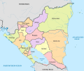 Nicaragua, administrative divisions - de - colored.svg 1,400 × 1,192; 402 KB
-
 Nicaragua, administrative divisions - de - monochrome.svg 1,400 × 1,192; 403 KB
-
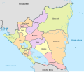 Nicaragua, administrative divisions - et - colored.svg 1,400 × 1,192; 302 KB
-
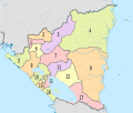 Nicaragua, administrative divisions - Nmbrs - colored.svg 1,400 × 1,192; 402 KB
-
 Nicaragua, administrative divisions - Nmbrs - monochrome.svg 1,400 × 1,192; 403 KB
-
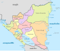 Nicaragua, administrative divisions - th - colored.svg 1,400 × 1,192; 671 KB


