Design Guidelines are based on → location map design of the German map shop. Thus they also follow the widespread locator maps design (→ SVG locator maps (location map scheme)). Their design principles (→ design guidelines) continue to be a basis for derived administrative maps. It's recommended to take one of the latter locator maps as a basis, to derive new administrative maps. Textstyle is supposed to follow the styles presented in the template SVG-file above. Colors should be directly picked from the maps shown below. Please be aware that this guide is only a recommendation. It's not an inevitable law!
EXAMPLES
Poland, simple color scheme, language-neutral labels
Denmark, colored
with detailed mini map
markers for small remote territories
zoom in order to show details of tiny remote territories
inlay maps for remote areas
area codes
intercontinental state
EU + overseas territories
1st and 2nd-tier divisions in one map
for crazy distributed and hard to see insular areas


.svg)


_(Paris_zoom).svg)
.svg)
,_administrative_divisions_-_de_-_colored_(multizoom).svg)
_-_colored.svg)
.svg)
,_administrative_divisions_-_Nmbrs_(multizoom).svg)
,_administrative_divisions_-_de_-_colored.svg)
_-_de_-_colored.svg)

.svg)

.svg)
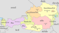 Austria, administrative divisions - th - colored.svg 1,256 × 700; 868 KB