Category:SVG labeled maps of administrative divisions of Ivory Coast (location map scheme)
Jump to navigation
Jump to search


.svg)


_(Paris_zoom).svg)
.svg)
,_administrative_divisions_-_de_-_colored_(multizoom).svg)
_-_colored.svg)
.svg)
,_administrative_divisions_-_Nmbrs_(multizoom).svg)
,_administrative_divisions_-_de_-_colored.svg)
_-_de_-_colored.svg)

.svg)

.svg)
Media in category "SVG labeled maps of administrative divisions of Ivory Coast (location map scheme)"
The following 9 files are in this category, out of 9 total.
-
 Abidjan Communes.svg 593 × 398; 53 KB
-
 Côte d'Ivoire, administrative divisions - de - colored.svg 1,400 × 1,414; 350 KB
-
 Côte d'Ivoire, administrative divisions - de - colored2.svg 1,323 × 1,336; 673 KB
-
 Côte d'Ivoire, administrative divisions - de - monochrome.svg 1,400 × 1,414; 350 KB
-
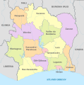 Côte d'Ivoire, administrative divisions - et - colored.svg 1,323 × 1,336; 681 KB
-
 Côte d'Ivoire, administrative divisions - fr - colored2.svg 1,323 × 1,336; 690 KB
-
 Côte d'Ivoire, administrative divisions - Nmbrs - colored.svg 1,400 × 1,414; 350 KB
-
 Côte d'Ivoire, administrative divisions - Nmbrs - monochrome.svg 1,400 × 1,414; 351 KB
-
 Côte d'Ivoire, administrative divisions - th - colored.svg 1,323 × 1,336; 818 KB


