Category:SVG labeled maps of administrative divisions of Montenegro (location map scheme)
Jump to navigation
Jump to search


.svg)


_(Paris_zoom).svg)
.svg)
,_administrative_divisions_-_de_-_colored_(multizoom).svg)
_-_colored.svg)
.svg)
,_administrative_divisions_-_Nmbrs_(multizoom).svg)
,_administrative_divisions_-_de_-_colored.svg)
_-_de_-_colored.svg)

.svg)

.svg)
Media in category "SVG labeled maps of administrative divisions of Montenegro (location map scheme)"
The following 11 files are in this category, out of 11 total.
-
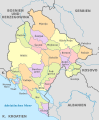
 Montenegro, administrative divisions - de - colored 2018.svg 1,063 × 1,285; 235 KB
-
 Montenegro, administrative divisions - de - colored 2022.svg 1,063 × 1,285; 241 KB
-
 Montenegro, administrative divisions - de - colored.svg 1,063 × 1,285; 234 KB
-
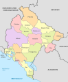
 Montenegro, administrative divisions - de.svg 1,063 × 1,285; 226 KB
-
 Montenegro, administrative divisions - et - colored.svg 1,063 × 1,285; 261 KB
-
 Montenegro, administrative divisions - Nmbrs - colored.svg 1,063 × 1,285; 180 KB
-
 Montenegro, administrative divisions - Nmbrs.svg 1,063 × 1,285; 140 KB
-
 Montenegro, administrative divisions - sq - colored 2022.svg 996 × 1,205; 229 KB
-
 Montenegro, administrative divisions - SQ.svg 1,063 × 1,285; 181 KB
-
 Montenegro, administrative divisions - th - colored 2022.svg 1,063 × 1,285; 472 KB
-
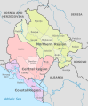 Statistical regions of Montenegro.svg 1,063 × 1,285; 308 KB


