Category:SVG labeled maps of administrative divisions of Dominica (location map scheme)
Jump to navigation
Jump to search


.svg)


_(Paris_zoom).svg)
.svg)
,_administrative_divisions_-_de_-_colored_(multizoom).svg)
_-_colored.svg)
.svg)
,_administrative_divisions_-_Nmbrs_(multizoom).svg)
,_administrative_divisions_-_de_-_colored.svg)
_-_de_-_colored.svg)

.svg)

.svg)
Media in category "SVG labeled maps of administrative divisions of Dominica (location map scheme)"
The following 9 files are in this category, out of 9 total.
-
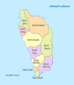
 Dominica, administrative divisions - de - colored.svg 1,104 × 1,260; 283 KB
-
 Dominica, administrative divisions - de - monochrome.svg 1,104 × 1,260; 283 KB
-
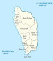
 Dominica, administrative divisions - en - monochrome.svg 2,500 × 3,700; 119 KB
-
 Dominica, administrative divisions - eo - monochrome.svg 2,500 × 3,700; 120 KB
-
 Dominica, administrative divisions - et - colored.svg 1,104 × 1,260; 304 KB
-
 Dominica, administrative divisions - mk - monochrome.svg 2,500 × 3,700; 120 KB
-
 Dominica, administrative divisions - Nmbrs - colored.svg 1,104 × 1,260; 283 KB
-
 Dominica, administrative divisions - Nmbrs - monochrome.svg 1,104 × 1,260; 283 KB
-
 Dominica, administrative divisions - th - colored.svg 1,104 × 1,260; 354 KB


