Category:SVG labeled maps of administrative divisions of countries of North America (location map scheme) (thai)
Jump to navigation
Jump to search


.svg)


_(Paris_zoom).svg)
.svg)
,_administrative_divisions_-_de_-_colored_(multizoom).svg)
_-_colored.svg)
.svg)
,_administrative_divisions_-_Nmbrs_(multizoom).svg)
,_administrative_divisions_-_de_-_colored.svg)
_-_de_-_colored.svg)

.svg)

.svg)
Media in category "SVG labeled maps of administrative divisions of countries of North America (location map scheme) (thai)"
The following 22 files are in this category, out of 22 total.
-
 Antigua and Barbuda, administrative divisions - th - colored.svg 864 × 994; 379 KB
-
 Bahamas, administrative divisions - th - colored.svg 1,559 × 1,124; 1.42 MB
-
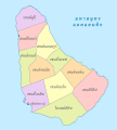 Barbados, administrative divisions - th - colored.svg 964 × 1,071; 233 KB
-
 Belize, administrative divisions - th - colored.svg 788 × 1,092; 347 KB
-
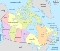 Canada, administrative divisions - th - colored.svg 1,084 × 920; 519 KB
-
 Costa Rica, administrative divisions - th - colored.svg 1,148 × 1,034; 491 KB
-
 Cuba, administrative divisions - th - colored.svg 1,795 × 761; 1.55 MB
-
 Dominica, administrative divisions - th - colored.svg 1,104 × 1,260; 354 KB
-
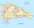 Dominican Republic, administrative divisions - th - colored.svg 1,400 × 1,139; 841 KB
-
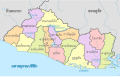 El Salvador, administrative divisions - th - colored.svg 983 × 624; 493 KB
-
 Grenada, administrative divisions - th - colored.svg 1,435 × 1,356; 425 KB
-
 Guatemala, administrative divisions - th - colored.svg 982 × 1,080; 515 KB
-
 Haiti, administrative divisions - th - colored.svg 1,357 × 1,057; 496 KB
-
 Honduras, administrative divisions - th - colored.svg 738 × 458; 853 KB
-
 Jamaica, administrative divisions (parishes+counties) - th - colored.svg 1,134 × 546; 494 KB
-
 Mexico, administrative divisions - th - colored.svg 2,029 × 1,326; 1.25 MB
-
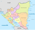 Nicaragua, administrative divisions - th - colored.svg 1,400 × 1,192; 671 KB
-
 Panama, administrative divisions - th - colored.svg 1,246 × 628; 790 KB
-
 Saint Kitts and Nevis, administrative divisions - th - colored.svg 1,011 × 936; 626 KB
-
 Saint Lucia, administrative divisions - th - colored 2014.svg 1,060 × 1,337; 383 KB
-
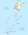 Saint Vincent and the Grenadines, administrative divisions - th - colored.svg 1,590 × 1,998; 537 KB
-
 United States (US50), administrative divisions - th - colored.svg 2,078 × 1,457; 781 KB


_-_th_-_colored.svg)


,_administrative_divisions_-_th_-_colored.svg)