Category:SVG labeled maps of administrative divisions of countries of North America (location map scheme) (spanish)
Jump to navigation
Jump to search


.svg)


_(Paris_zoom).svg)
.svg)
,_administrative_divisions_-_de_-_colored_(multizoom).svg)
_-_colored.svg)
.svg)
,_administrative_divisions_-_Nmbrs_(multizoom).svg)
,_administrative_divisions_-_de_-_colored.svg)
_-_de_-_colored.svg)

.svg)

.svg)
Media in category "SVG labeled maps of administrative divisions of countries of North America (location map scheme) (spanish)"
The following 10 files are in this category, out of 10 total.
-
 Belize, administrative divisions - es - monochrome.svg 788 × 1,092; 178 KB
-
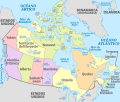 Canada, administrative divisions - es - colored.svg 1,084 × 920; 928 KB
-
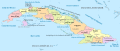 Cuba, administrative divisions - es - colored.svg 1,795 × 761; 1.35 MB
-
 Departments of Guatemala (es).svg 512 × 563; 222 KB
-
 Panama, administrative divisions - es - colored.svg 1,242 × 623; 372 KB
-
 Regions of Guatemala (es).svg 512 × 563; 265 KB
-
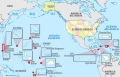 United States (+overseas), administrative divisions - es - colored (zoom).svg 1,339 × 864; 5.36 MB
-
 United States, administrative divisions - es - colored.svg 1,181 × 731; 3.22 MB
-
 USA Puerto Rico consolidation.svg 1,058 × 325; 98 KB
-
 USA Puerto Rico labeled.svg 1,058 × 325; 171 KB


.svg)

.svg)
,_administrative_divisions_-_es_-_colored_(zoom).svg)
