Category:Maps of groups of communes in Landes
Jump to navigation
Jump to search
Departments of Metropolitan France: Ain [01] · Aisne [02] · Allier [03] · Alpes-de-Haute-Provence [04] · Hautes-Alpes [05] · Alpes-Maritimes [06] · Ardèche [07] · Ardennes [08] · Ariège [09] · Aube [10] · Aude [11] · Aveyron [12] · Bouches-du-Rhône [13] · Calvados [14] · Cantal [15] · Charente [16] · Charente-Maritime [17] · Cher [18] · Corrèze [19] · Corse-du-Sud [2A]† · Haute-Corse [2B]† · Côte-d’Or [21] · Côtes-d'Armor [22] · Creuse [23] · Dordogne [24] · Doubs [25] · Drôme [26] · Eure [27] · Eure-et-Loir [28] · Finistère [29] · Gard [30] · Haute-Garonne [31] · Gers [32] · Gironde [33] · Hérault [34] · Ille-et-Vilaine [35] · Indre [36] · Indre-et-Loire [37] · Isère [38] · Jura [39] · Landes [40] · Loir-et-Cher [41] · Loire [42] · Haute-Loire [43] · Loire-Atlantique [44] · Loiret [45] · Lot [46] · Lot-et-Garonne [47] · Lozère [48] · Maine-et-Loire [49] · Manche [50] · Marne [51] · Haute-Marne [52] · Mayenne [53] · Meurthe-et-Moselle [54] · Meuse [55] · Morbihan [56] · Moselle [57] · Nièvre [58] · Nord [59] · Oise [60] · Orne [61] · Pas-de-Calais [62] · Puy-de-Dôme [63] · Pyrénées-Atlantiques [64] · Hautes-Pyrénées [65] · Pyrénées-Orientales [66] · Bas-Rhin [67] · Haut-Rhin [68] · departmental district of the Rhône [69] · Rhône [69D]‡ · Haute-Saône [70] · Saône-et-Loire [71] · Sarthe [72] · Savoie [73] · Haute-Savoie [74] · Seine-Maritime [76] · Seine-et-Marne [77] · Yvelines [78] · Deux-Sèvres [79] · Somme [80] · Tarn [81] · Tarn-et-Garonne [82] · Var [83] · Vaucluse [84] · Vendée [85] · Vienne [86] · Haute-Vienne [87] · Vosges [88] · Yonne [89] · Territoire de Belfort [90] · Essonne [91] · Hauts-de-Seine [92] · Seine-Saint-Denis [93] · Val-de-Marne [94] · Val-d'Oise [95]
Overseas departments and regions: Guadeloupe [971] · Martinique [972] · French Guiana [973] · Réunion [974] · Mayotte [976]
Sui generis territories: New Caledonia [988]
Overseas departments and regions: Guadeloupe [971] · Martinique [972] · French Guiana [973] · Réunion [974] · Mayotte [976]
Sui generis territories: New Caledonia [988]
| NO WIKIDATA ID FOUND! Search for Maps of groups of communes in Landes on Wikidata | |
| Upload media |
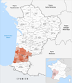
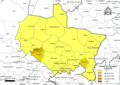
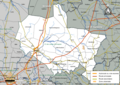
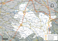
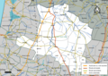
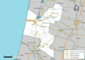
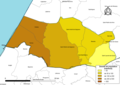
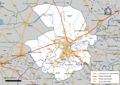
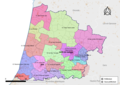
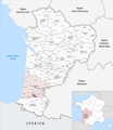
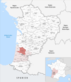
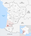
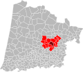
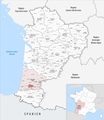
Français : Cartes des établissements publics de coopération intercommunale (communautés de communes, d’agglomération ou urbaines, métropoles, syndicats intercommunaux) et syndicats mixtes (dont les pôles métropolitains) du département français des Landes.

Subcategories
This category has the following 3 subcategories, out of 3 total.
Media in category "Maps of groups of communes in Landes"
The following 80 files are in this category, out of 80 total.
-
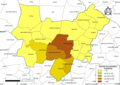
 Gemeindeverbände im Département Landes 2023.png 3,500 × 4,020; 3.09 MB
-
 40-Intercos2019-200030435-Densités.png 3,519 × 2,480; 1.61 MB
-
 40-Intercos2019-200035541-Densités.png 3,519 × 2,480; 1.64 MB
-
 40-Intercos2019-200035541.png 3,519 × 2,480; 2.98 MB
-
 40-Intercos2019-200069417-Densités.png 3,519 × 2,480; 1.62 MB
-
 40-Intercos2019-200069417.png 3,519 × 2,480; 3.01 MB
-
 40-Intercos2019-200069631-Densités.png 3,519 × 2,480; 1.4 MB
-
 40-Intercos2019-200069631.png 3,519 × 2,480; 2.43 MB
-
 40-Intercos2019-200069649-Densités.png 3,519 × 2,480; 2.33 MB
-
 40-Intercos2019-200069649.png 3,519 × 2,480; 3.84 MB
-
 40-Intercos2019-200069656-Densités.png 3,519 × 2,480; 1.46 MB
-
 40-Intercos2019-200069656.png 3,519 × 2,480; 3.13 MB
-
 40-Intercos2019-244000543-Densités.png 3,519 × 2,480; 708 KB
-
 40-Intercos2019-244000543.png 3,519 × 2,480; 1.51 MB
-
 40-Intercos2019-244000659-Densités.png 3,519 × 2,480; 869 KB
-
 40-Intercos2019-244000659.png 3,519 × 2,480; 2.12 MB
-
 40-Intercos2019-244000675-Densités.png 3,519 × 2,480; 1.22 MB
-
 40-Intercos2019-244000675.png 3,519 × 2,480; 2.46 MB
-
 40-Intercos2019-244000691-Densités.png 3,519 × 2,480; 767 KB
-
 40-Intercos2019-244000691.png 3,519 × 2,480; 1.73 MB
-
 40-Intercos2019-244000766-Densités.png 3,519 × 2,480; 1.07 MB
-
 40-Intercos2019-244000766.png 3,519 × 2,480; 2.19 MB
-
 40-Intercos2019-244000774-Densités.png 3,519 × 2,480; 1.38 MB
-
 40-Intercos2019-244000774.png 3,519 × 2,480; 2.39 MB
-
 40-Intercos2019-244000808-Densités.png 3,519 × 2,480; 1.27 MB
-
 40-Intercos2019-244000808.png 3,519 × 2,480; 2.52 MB
-
 40-Intercos2019-244000824-Densités.png 3,519 × 2,480; 1,018 KB
-
 40-Intercos2019-244000824.png 3,519 × 2,480; 1.88 MB
-
 40-Intercos2019-244000857-Densités.png 3,519 × 2,480; 819 KB
-
 40-Intercos2019-244000857.png 3,519 × 2,480; 1.72 MB
-
 40-Intercos2019-244000865-Densités.png 3,519 × 2,480; 1.45 MB
-
 40-Intercos2019-244000865.png 3,519 × 2,480; 2.83 MB
-
 40-Intercos2019-244000873-Densités.png 3,519 × 2,480; 811 KB
-
 40-Intercos2019-244000873.png 3,519 × 2,480; 1.86 MB
-
 40-Intercos2019-244000881-Densités.png 3,519 × 2,480; 1.2 MB
-
 40-Intercos2019-244000881.png 3,519 × 2,480; 2.01 MB
-
 40-Landes-intercos-2019.png 3,507 × 2,480; 1.9 MB
-
 Gemeindeverband Aire-sur-l’Adour - Nouvelle-Aquitaine 2019.png 3,500 × 4,020; 3.08 MB
-
 Gemeindeverband Chalosse Tursan 2019.png 3,500 × 4,020; 3.08 MB
-
 Gemeindeverband Coteaux et Vallées des Luys 2019.png 3,500 × 4,020; 3.08 MB
-
 Gemeindeverband Côte Landes Nature 2019.png 3,500 × 4,020; 3.08 MB
-
 Gemeindeverband Cœur Haute Lande 2019.png 3,500 × 4,020; 3.08 MB
-
 Gemeindeverband Grand Dax 2019.png 3,500 × 4,020; 3.08 MB
-
 Gemeindeverband Grands Lacs 2019.png 3,500 × 4,020; 3.08 MB
-
 Gemeindeverband Landes d’Armagnac 2019.png 3,500 × 4,020; 3.08 MB
-
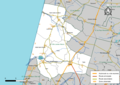
 Localisation EPCI Coteaux et vallées des Luys dans les Landes, France.svg 1,000 × 873; 144 KB
-
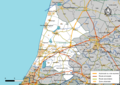
 Localisation EPCI Côte Landes nature dans les Landes, France.svg 1,000 × 873; 143 KB
-
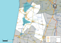
 Localisation EPCI Cœur Haute Lande dans les Landes, France.svg 1,000 × 873; 151 KB
-
 Localisation EPCI d'Aire-sur-l'Adour dans les Landes, France.svg 1,000 × 873; 151 KB
-
 Localisation EPCI de la haute Lande dans les Landes, France.svg 1,000 × 873; 143 KB
-
 Localisation EPCI de Mimizan dans les Landes, France.svg 1,000 × 873; 143 KB
-
 Localisation EPCI de Pouillon dans les Landes, France.svg 1,000 × 873; 143 KB
-
 Localisation EPCI des grands lacs dans les Landes, France.svg 1,000 × 873; 143 KB
-
 Localisation EPCI des landes d'Armagnac dans les Landes, France.svg 1,000 × 873; 144 KB
-
 Localisation EPCI du canton de Montfort-en-Chalosse dans les Landes, France.svg 1,000 × 873; 144 KB
-
 Localisation EPCI du canton de Mugron dans les Landes, France.svg 1,000 × 873; 143 KB
-
 Localisation EPCI du canton de Pissos dans les Landes, France.svg 1,000 × 873; 143 KB
-
 Localisation EPCI du cap de Gascogne dans les Landes, France.svg 1,000 × 873; 144 KB
-
 Localisation EPCI du Grand Dax dans les Landes, France.svg 1,000 × 873; 144 KB
-
 Localisation EPCI du pays d'Albret dans les Landes, France.svg 1,000 × 873; 143 KB
-
 Localisation EPCI du pays d'Orthe dans les Landes, France.svg 1,000 × 873; 144 KB
-

-
 Localisation EPCI du pays grenadois dans les Landes, France.svg 1,000 × 873; 143 KB
-
 Localisation EPCI du pays morcenais dans les Landes, France.svg 1,000 × 873; 143 KB
-
 Localisation EPCI du pays tarusate dans les Landes, France.svg 1,000 × 873; 144 KB
-
 Localisation EPCI du Seignanx dans les Landes, France.svg 1,000 × 873; 143 KB
-
 Localisation EPCI du Tursan dans les Landes, France.svg 1,000 × 873; 144 KB
-
 Localisation EPCI Hagetmau communes unies dans les Landes, France.svg 1,000 × 873; 144 KB
-
 Localisation EPCI le Marsan Agglomération dans les Landes, France.svg 1,000 × 873; 144 KB
-
 Localisation EPCI Maremne Adour Côte sud dans les Landes, France.svg 1,000 × 873; 144 KB
-
 Gemeindeverband Maremne Adour Côte Sud 2019.png 3,500 × 4,020; 3.08 MB
-
 Gemeindeverband Mimizan 2019.png 3,500 × 4,020; 3.08 MB
-
 Gemeindeverband Mont-de-Marsan Agglomération 2019.png 3,500 × 4,020; 3.08 MB
-
 Gemeindeverband Pays de Villeneuve en Armagnac Landais 2019.png 3,500 × 4,020; 3.08 MB
-
 Gemeindeverband Pays d’Orthe et Arrigans 2019.png 3,500 × 4,020; 3.08 MB
-
 Gemeindeverband Pays Grenadois 2019.png 3,500 × 4,020; 3.08 MB
-
 Gemeindeverband Pays Morcenais 2019.png 3,500 × 4,020; 3.08 MB
-
 Gemeindeverband Pays Tarusate 2019.png 3,500 × 4,020; 3.08 MB
-
 Gemeindeverband Seignanx 2019.png 3,500 × 4,020; 3.08 MB
-
 Gemeindeverband Terres de Chalosse 2019.png 3,500 × 4,020; 3.08 MB


