
Category:Maps of groups of communes in Charente
Departments of Metropolitan France: Ain [01] · Aisne [02] · Allier [03] · Alpes-de-Haute-Provence [04] · Hautes-Alpes [05] · Alpes-Maritimes [06] · Ardèche [07] · Ardennes [08] · Ariège [09] · Aube [10] · Aude [11] · Aveyron [12] · Bouches-du-Rhône [13] · Calvados [14] · Cantal [15] · Charente [16] · Charente-Maritime [17] · Cher [18] · Corrèze [19] · Corse-du-Sud [2A]† · Haute-Corse [2B]† · Côte-d’Or [21] · Côtes-d'Armor [22] · Creuse [23] · Dordogne [24] · Doubs [25] · Drôme [26] · Eure [27] · Eure-et-Loir [28] · Finistère [29] · Gard [30] · Haute-Garonne [31] · Gers [32] · Gironde [33] · Hérault [34] · Ille-et-Vilaine [35] · Indre [36] · Indre-et-Loire [37] · Isère [38] · Jura [39] · Landes [40] · Loir-et-Cher [41] · Loire [42] · Haute-Loire [43] · Loire-Atlantique [44] · Loiret [45] · Lot [46] · Lot-et-Garonne [47] · Lozère [48] · Maine-et-Loire [49] · Manche [50] · Marne [51] · Haute-Marne [52] · Mayenne [53] · Meurthe-et-Moselle [54] · Meuse [55] · Morbihan [56] · Moselle [57] · Nièvre [58] · Nord [59] · Oise [60] · Orne [61] · Pas-de-Calais [62] · Puy-de-Dôme [63] · Pyrénées-Atlantiques [64] · Hautes-Pyrénées [65] · Pyrénées-Orientales [66] · Bas-Rhin [67] · Haut-Rhin [68] · departmental district of the Rhône [69] · Rhône [69D]‡ · Haute-Saône [70] · Saône-et-Loire [71] · Sarthe [72] · Savoie [73] · Haute-Savoie [74] · Seine-Maritime [76] · Seine-et-Marne [77] · Yvelines [78] · Deux-Sèvres [79] · Somme [80] · Tarn [81] · Tarn-et-Garonne [82] · Var [83] · Vaucluse [84] · Vendée [85] · Vienne [86] · Haute-Vienne [87] · Vosges [88] · Yonne [89] · Territoire de Belfort [90] · Essonne [91] · Hauts-de-Seine [92] · Seine-Saint-Denis [93] · Val-de-Marne [94] · Val-d'Oise [95]
Overseas departments and regions: Guadeloupe [971] · Martinique [972] · French Guiana [973] · Réunion [974] · Mayotte [976]
Sui generis territories: New Caledonia [988]
Overseas departments and regions: Guadeloupe [971] · Martinique [972] · French Guiana [973] · Réunion [974] · Mayotte [976]
Sui generis territories: New Caledonia [988]
| NO WIKIDATA ID FOUND! Search for Maps of groups of communes in Charente on Wikidata | |
| Upload media |
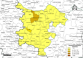
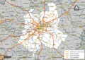
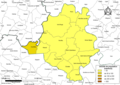
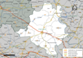
Français : Cartes des établissements publics de coopération intercommunale (communautés de communes, d’agglomération ou urbaines, métropoles, syndicats intercommunaux) et syndicats mixtes (dont les pôles métropolitains) du département français de la Charente.

Subcategories
This category has the following 7 subcategories, out of 7 total.
2
Media in category "Maps of groups of communes in Charente"
The following 56 files are in this category, out of 56 total.
-
 Gemeindeverbände im Département Charente 2025.png 3,500 × 4,020; 3.55 MB
-
 16-Intercos-2019.png 3,507 × 2,480; 1.77 MB
-
 16-Intercos2019-200029734-Densités.png 3,519 × 2,480; 2.27 MB
-
 16-Intercos2019-200043016-Densités.png 3,519 × 2,480; 1.51 MB
-
 16-Intercos2019-200043016.png 3,519 × 2,480; 2.49 MB
-
 16-Intercos2019-200068914-Densités.png 3,519 × 2,480; 2.03 MB
-
 16-Intercos2019-200070282-Densités.png 3,519 × 2,480; 2.4 MB
-
 16-Intercos2019-200070282.png 3,519 × 2,480; 3.67 MB
-
 16-Intercos2019-200070514-Densités.png 3,519 × 2,480; 2.18 MB
-
 16-Intercos2019-200070514.png 3,519 × 2,480; 3.49 MB
-
 16-Intercos2019-200071827-Densités.png 3,519 × 2,480; 2.09 MB
-
 16-Intercos2019-200071827.png 3,519 × 2,480; 3.94 MB
-
 16-Intercos2019-200072023-Densités.png 3,519 × 2,480; 1.99 MB
-
 16-Intercos2019-200072023.png 3,519 × 2,480; 3.27 MB
-
 16-Intercos2019-200072049-Densités.png 3,519 × 2,480; 2.65 MB
-
 16-Intercos2019-200072049.png 3,519 × 2,480; 4.65 MB
-
 16-Intercos2019-241600303-Densités.png 3,519 × 2,480; 1.52 MB
-
 16-Intercos2019-241600303.png 3,519 × 2,480; 2.58 MB
-
 Gemeindeverband 4B Sud Charente 2019.png 3,500 × 4,020; 3.11 MB
-
 Gemeindeverband Charente Limousine 2019.png 3,500 × 4,020; 3.11 MB
-
 Comunas e lengas de Charanta - CC Charanta Lemosina.png 938 × 903; 343 KB
-

-
 Gemeindeverband Cœur de Charente 2025.png 3,500 × 4,020; 3.54 MB
-
 Gemeindeverband Grand Angoulême 2019.png 3,500 × 4,020; 3.11 MB
-
 Gemeindeverband Grand Cognac 2024.png 3,500 × 4,020; 3.11 MB
-
 Intercos2019-200029734.png 3,519 × 2,480; 3.72 MB
-
 Gemeindeverband La Rochefoucauld - Porte du Périgord 2023.png 3,500 × 4,020; 3.12 MB
-
 Gemeindeverband Lavalette Tude Dronne 2025.png 3,500 × 4,020; 3.54 MB
-
 Localisation EPCI Bandiat - Tardoire dans la Charente, France.svg 1,000 × 963; 166 KB
-
 Localisation EPCI Braconne et Charente dans la Charente, France.svg 1,000 × 963; 166 KB
-
 Localisation EPCI Charente Boëme Charraud dans la Charente, France.svg 1,000 × 963; 166 KB
-
 Localisation EPCI d'Horte et Lavalette dans la Charente, France.svg 1,000 × 963; 166 KB
-
 Localisation EPCI de Cognac dans la Charente, France.svg 1,000 × 963; 166 KB
-
 Localisation EPCI de grande Champagne dans la Charente, France.svg 1,000 × 963; 166 KB
-
 Localisation EPCI de haute Charente dans la Charente, France.svg 1,000 × 963; 166 KB
-
 Localisation EPCI de Jarnac dans la Charente, France.svg 1,000 × 963; 166 KB
-
 Localisation EPCI de la Boixe dans la Charente, France.svg 1,000 × 963; 166 KB
-
 Localisation EPCI de la région de Châteauneuf dans la Charente, France.svg 1,000 × 963; 166 KB
-
 Localisation EPCI de la vallée de l'Échelle dans la Charente, France.svg 1,000 × 963; 166 KB
-
 Localisation EPCI de Ruffec dans la Charente, France.svg 1,000 × 963; 166 KB
-
 Localisation EPCI des quatre B dans la Charente, France.svg 1,000 × 963; 167 KB
-
 Localisation EPCI des trois vallées dans la Charente, France.svg 1,000 × 963; 166 KB
-
 Localisation EPCI du Confolentais dans la Charente, France.svg 1,000 × 963; 166 KB
-
 Localisation EPCI du Grand Angoulême dans la Charente, France.svg 1,000 × 963; 166 KB
-
 Localisation EPCI du Montmorélien dans la Charente, France.svg 1,000 × 963; 166 KB
-
 Localisation EPCI du pays d'Aigre dans la Charente, France.svg 1,000 × 963; 166 KB
-
 Localisation EPCI du pays d'Aubeterre dans la Charente, France.svg 1,000 × 963; 166 KB
-
 Localisation EPCI du pays de Chalais dans la Charente, France.svg 1,000 × 963; 166 KB
-
 Localisation EPCI du pays de Villefagnan dans la Charente, France.svg 1,000 × 963; 166 KB
-
 Localisation EPCI du pays manslois dans la Charente, France.svg 1,000 × 963; 166 KB
-
 Localisation EPCI du Rouillacais dans la Charente, France.svg 1,000 × 963; 166 KB
-
 Localisation EPCI Seuil Charente Périgord dans la Charente, France.svg 1,000 × 963; 166 KB
-
 Localisation EPCI Tude et Dronne dans la Charente, France.svg 1,000 × 963; 167 KB
-
 Localisation EPCI Val de Charente dans la Charente, France.svg 1,000 × 963; 166 KB
-
 Gemeindeverband Rouillacais 2019.png 3,500 × 4,020; 3.11 MB
-
 Gemeindeverband Val de Charente 2019.png 3,500 × 4,020; 3.11 MB


