Category:Maps of rivers in New Mexico
Jump to navigation
Jump to search
States of the United States: Alabama · Alaska · Arizona · Arkansas · California · Colorado · Connecticut · Delaware · Florida · Georgia · Idaho · Illinois · Indiana · Iowa · Kansas · Kentucky · Louisiana · Maine · Maryland · Massachusetts · Michigan · Minnesota · Mississippi · Missouri · Montana · Nebraska · Nevada · New Hampshire · New Jersey · New Mexico · New York · North Carolina · North Dakota · Ohio · Oklahoma · Oregon · Pennsylvania · Rhode Island · South Carolina · South Dakota · Tennessee · Texas · Utah · Vermont · Virginia · Washington · West Virginia · Wisconsin · Wyoming – Washington, D.C.
- English: Maps of the Rivers in New Mexico.
Media in category "Maps of rivers in New Mexico"
The following 16 files are in this category, out of 16 total.
-
 72d - Cuyama River, California - DPLA - f087e3065b77e03b6a4702af2e25316c.jpg 13,787 × 10,867; 16.24 MB
-
 77d - Rio Grande, New Mexico - DPLA - 5950079a471eedb1153204fe456a144f.jpg 15,760 × 9,542; 25.33 MB
-
 Arkansasrivermap.jpg 771 × 533; 259 KB
-
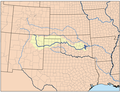
 Canadian River basin map.png 1,200 × 759; 1.45 MB
-
 Canadianrivermap.png 500 × 385; 204 KB
-
 Coloradorivermap (Utah detail).jpg 799 × 652; 402 KB
-
 Coloradorivermapnew1.jpg 871 × 1,130; 701 KB
-
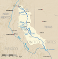 Pecosmap.png 864 × 888; 860 KB
-
 Rio Grande dams and diversions.svg 1,000 × 1,181; 2.65 MB
-
 Rio-Chama-NM-Map-USACE-2007.png 1,672 × 1,114; 116 KB
-
 Riogrande watershed.png 498 × 500; 182 KB
-
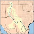
 Riogranderivermap.png 1,000 × 1,181; 1.95 MB
-
 RioGrandeRiverMapNM.png 514 × 585; 558 KB
-
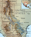
 Sanjuanrivermap-new.png 2,030 × 1,749; 3.91 MB
-
 Sanjuanrivermap.jpg 617 × 429; 247 KB
-
 Wpdms nasa topo gila river.jpg 300 × 300; 60 KB


.jpg)


