Category:Maps of rivers in Kansas
Jump to navigation
Jump to search
States of the United States: Alabama · Alaska · Arizona · Arkansas · California · Colorado · Connecticut · Delaware · Florida · Georgia · Idaho · Illinois · Indiana · Iowa · Kansas · Kentucky · Louisiana · Maine · Maryland · Massachusetts · Michigan · Minnesota · Mississippi · Missouri · Montana · Nebraska · Nevada · New Hampshire · New Jersey · New Mexico · New York · North Carolina · North Dakota · Ohio · Oklahoma · Oregon · Pennsylvania · Rhode Island · South Carolina · South Dakota · Tennessee · Texas · Utah · Vermont · Virginia · Washington · West Virginia · Wisconsin · Wyoming – Washington, D.C.
Subcategories
This category has only the following subcategory.
M
- Maps of the Arkansas River (19 F)
Media in category "Maps of rivers in Kansas"
The following 19 files are in this category, out of 19 total.
-
 Arkansas river basin map.png 1,200 × 759; 1.46 MB
-
 Arkansasrivermap.jpg 771 × 533; 259 KB
-
 Kansasrivermap.png 654 × 500; 308 KB
-
 Kc-rivers.png 1,200 × 834; 60 KB
-
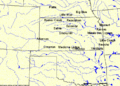
 Ks rivers.png 1,000 × 764; 495 KB
-
 Ks-rivers.gif 777 × 559; 112 KB
-
-
-

-
-

-

-
 Republican River with Beecher Island highlighted.png 2,047 × 835; 760 KB
-
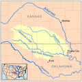 Saltforkarkansasrivermap.png 500 × 500; 118 KB
-
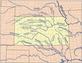
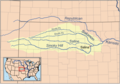 Smokyhillrivermap.png 711 × 500; 308 KB
-
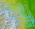 Wpdms nasa topo big blue river.jpg 300 × 250; 45 KB
-
 Wpdms nasa topo solomon river.jpg 300 × 250; 45 KB
-
 Neoshorivermap.png 500 × 500; 129 KB
-
 Osagerivermap.png 750 × 750; 265 KB


,_to_Candor,_Kansas_(Wyandotte_County)_-_DPLA_-_94fdfc0492ae9188d8f521b216a8fcc0_(page_2).jpg)
,_to_Candor,_Kansas_(Wyandotte_County)_-_DPLA_-_94fdfc0492ae9188d8f521b216a8fcc0_(page_3).jpg)
,_to_Candor,_Kansas_(Wyandotte_County)_-_DPLA_-_94fdfc0492ae9188d8f521b216a8fcc0_(page_4).jpg)
,_to_Candor,_Kansas_(Wyandotte_County)_-_DPLA_-_94fdfc0492ae9188d8f521b216a8fcc0_(page_5).jpg)


,_to_Candor,_Kansas_(Wyandotte_County)_-_DPLA_-_94fdfc0492ae9188d8f521b216a8fcc0_(page_6).jpg)