Category:Maps of rivers in Nevada
Jump to navigation
Jump to search
States of the United States: Alabama · Alaska · Arizona · Arkansas · California · Colorado · Connecticut · Delaware · Florida · Georgia · Idaho · Illinois · Indiana · Iowa · Kansas · Kentucky · Louisiana · Maine · Maryland · Massachusetts · Michigan · Minnesota · Mississippi · Missouri · Montana · Nebraska · Nevada · New Hampshire · New Jersey · New Mexico · New York · North Carolina · North Dakota · Ohio · Oklahoma · Oregon · Pennsylvania · Rhode Island · South Carolina · South Dakota · Tennessee · Texas · Utah · Vermont · Virginia · Washington · West Virginia · Wisconsin · Wyoming – Washington, D.C.
- English: Maps of the Rivers in Nevada.
Subcategories
This category has the following 3 subcategories, out of 3 total.
Media in category "Maps of rivers in Nevada"
The following 15 files are in this category, out of 15 total.
-

-
 Carsonrivermap.png 500 × 500; 335 KB
-
 Coloradorivermap (Utah detail).jpg 799 × 652; 402 KB
-
 Coloradorivermapnew1.jpg 871 × 1,130; 701 KB
-
 Map No. IV, West Half, Humboldt River - NARA - 93193121.jpg 7,040 × 9,618; 5.16 MB
-
 Map No. V, East Half, Humboldt River - NARA - 93193125.jpg 7,008 × 9,615; 5.57 MB
-
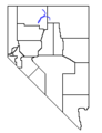 NVMap-doton-LittleHumRiver.png 165 × 215; 1 KB
-
 NVMap-doton-NoFkHumRiv.png 165 × 215; 1 KB
-
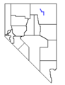
 NVMap-doton-ReeseRiver.png 165 × 215; 1 KB
-
 NVMap-doton-SoFkHumRiv.png 165 × 215; 1 KB
-
 Owyhee river basin map.png 1,000 × 1,372; 2.39 MB
-
 Owyheerivermap.jpg 937 × 1,109; 1.04 MB
-
 Quinnrivermap.png 500 × 500; 323 KB
-
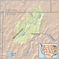
 Salmon falls creek map-01.png 869 × 860; 229 KB
-
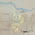
 Salmon falls creek.jpg 388 × 762; 241 KB


.jpg)


