Category:Maps of counties of New York (state)
Jump to navigation
Jump to search
States of the United States: Alabama · Alaska · Arizona · Arkansas · California · Colorado · Connecticut · Delaware · Florida · Georgia · Hawaii · Idaho · Illinois · Indiana · Iowa · Kansas · Kentucky · Louisiana · Maine · Maryland · Massachusetts · Michigan · Minnesota · Mississippi · Missouri · Montana · Nebraska · Nevada · New Hampshire · New Jersey · New Mexico · New York · North Carolina · North Dakota · Ohio · Oklahoma · Oregon · Pennsylvania · Rhode Island · South Carolina · South Dakota · Tennessee · Texas · Utah · Vermont · Virginia · Washington · West Virginia · Wisconsin · Wyoming
Counties of New York (state): Albany · Allegany · Bronx · Broome · Cattaraugus · Cayuga · Chautauqua · Chemung · Chenango · Clinton · Columbia · Cortland · Delaware · Dutchess · Erie · Essex · Franklin · Fulton · Genesee · Greene · Hamilton · Herkimer · Jefferson · Kings · Lewis · Livingston · Madison · Monroe · Montgomery · Nassau · New York · Niagara · Oneida · Onondaga · Ontario · Orange · Orleans · Oswego · Otsego · Putnam · Queens · Rensselaer · Richmond · Rockland · Saratoga · Schenectady · Schoharie · Schuyler · Seneca · St. Lawrence · Steuben · Suffolk · Sullivan · Tioga · Tompkins · Ulster · Warren · Washington · Wayne · Westchester · Wyoming · Yates
Subcategories
This category has the following 63 subcategories, out of 63 total.
*
A
B
C
D
E
F
G
- Maps of Genesee County, New York (28 F)
H
J
L
M
N
O
- Maps of Otsego County, New York (30 F)
P
- Maps of Putnam County, New York (24 F)
Q
R
S
T
U
W
- Maps of Warren County, New York (24 F)
Y
Media in category "Maps of counties of New York (state)"
The following 33 files are in this category, out of 33 total.
-

-
 Abies magnifica NY-dist-map.png 2,000 × 1,500; 64 KB
-
 All counties NY-dist-map.png 2,000 × 1,500; 59 KB
-
 All counties nymap.svg 668 × 501; 317 KB
-
 Annual report (1909) (14565032210).jpg 2,800 × 2,132; 1.23 MB
-
 Annual report (1909) (14565068358).jpg 2,800 × 2,144; 1.26 MB
-
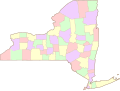
 Blank Map of New York Counties.svg 655 × 500; 425 KB
-
 Blank map subdivisions New York.svg 138 × 105; 36 KB
-
 Jurisdiction of the United States Attorney for the Southern District of New York.jpg 2,200 × 1,700; 290 KB
-
 Long Island Counties.gif 255 × 157; 4 KB
-
 Map of New York counties.PNG 300 × 232; 10 KB
-
 Map of New York counties.svg 633 × 476; 444 KB
-
 Map of New York County Outlines.svg 633 × 476; 506 KB
-
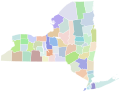
 New York counties and cities with sexual orientation and gender identity protection.svg 6,599 × 5,030; 188 KB
-
 New York Counties Map (without water).svg 1,200 × 800; 212 KB
-
 New York Counties Map.svg 1,200 × 800; 203 KB
-
 New York Counties.gif 866 × 696; 44 KB
-
 New York Counties.svg 763 × 595; 217 KB
-
 New York county map, cb 500k.svg 810 × 621; 62 KB
-
 New York, same-sex marriage by county.png 1,996 × 1,516; 184 KB
-
 New-york-counties-map.gif 937 × 735; 49 KB
-
 New-york-county-map.gif 750 × 514; 34 KB
-
 No counties NY-dist-map.png 2,000 × 1,500; 64 KB
-
 No counties nymap.svg 666 × 500; 315 KB
-
 NRHP New York Map.svg 990 × 765; 10.14 MB
-
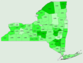
 NY per capita income by county 2010.png 655 × 492; 16 KB
-
 Onondaga.jpg 787 × 600; 70 KB
-
 Picea abies NY-dist-map.png 2,000 × 1,500; 63 KB
-
 Twintiers.png 423 × 328; 9 KB
-
 United States Eastern District of New York Counties.gif 866 × 696; 89 KB
-
 United States Northern District of New York counties.gif 866 × 696; 75 KB
-
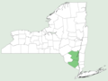
 United States Southern District of New York counties.gif 866 × 696; 88 KB
-
 United States Western District of New York counties.gif 866 × 696; 86 KB


_(14565032210).jpg)
_(14565068358).jpg)


.svg)


