Category:Topographic maps of Switzerland
Jump to navigation
Jump to search
Subcategories
This category has the following 6 subcategories, out of 6 total.
Media in category "Topographic maps of Switzerland"
The following 200 files are in this category, out of 218 total.
(previous page) (next page)-
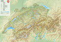 Reliefkarte Schweiz.png 10,129 × 6,935; 73.69 MB
-
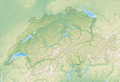 Reliefkarte Schweiz blank.png 10,130 × 6,934; 52.11 MB
-
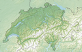 Reliefkarte Schweiz2.png 10,228 × 6,505; 59.46 MB
-
 Reliefkarte Schweiz3.png 10,226 × 6,503; 61.52 MB
-
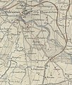 2021 01 30 Plan Ligne Tir 1902.jpg 1,768 × 2,075; 1.12 MB
-
 705x466-Suisse topog 5°5 11° 45°5 48°.PNG 705 × 466; 583 KB
-
 800x513-Carte-Suisse-R2.jpg 800 × 513; 150 KB
-
 800x513-Carte-Suisse-R4.jpg 800 × 513; 144 KB
-
 896x651-Carte-Suisse-R.png 896 × 651; 1.14 MB
-
 896x651-Carte-Suisse-R2.png 896 × 651; 794 KB
-
 Kanton Aargau blank.png 1,943 × 1,939; 3.27 MB
-
 Kanton Aargau Burgen und Schlösser.png 1,715 × 1,713; 2.85 MB
-
 Kanton Aargau Detail DE.png 1,943 × 2,271; 3.09 MB
-
 Kanton Aargau Detail.png 1,939 × 2,273; 3.81 MB
-
 Reliefkarte Aargau Aussichtstürme.png 1,897 × 1,868; 2.57 MB
-
 Reliefkarte Aargau blank.png 1,965 × 1,871; 3.64 MB
-
 Reliefkarte Aargau.png 2,113 × 1,868; 4.32 MB
-
 Reliefkarte Aargauer Seen.png 1,897 × 1,868; 2.59 MB
-
 Albula-Alpen.png 2,846 × 2,820; 2.1 MB
-

-
 Reliefkarte Appenzeller Seen.png 1,090 × 1,061; 1.17 MB
-
 Kanton Appenzell Ausserrhoden blank.png 1,429 × 1,339; 1.7 MB
-
 Kanton Appenzell Ausserrhoden Burgen und Schlösser.png 1,305 × 1,215; 1.57 MB
-
 Kanton Appenzell Ausserrhoden Detail DE.png 1,432 × 1,884; 2.37 MB
-
 Kanton Appenzell Ausserrhoden Detail.png 1,431 × 1,884; 2.1 MB
-
 Reliefkarte Appenzell Ausserrhoden blank.png 1,093 × 1,065; 1.09 MB
-
 Reliefkarte Appenzell Ausserrhoden.png 1,646 × 1,269; 1.84 MB
-
 Reliefkarte Appenzell Ausserrhoder Seen.png 1,091 × 1,065; 1.13 MB
-
 Kanton Appenzell Innerrhoden blank.png 1,431 × 1,341; 1.7 MB
-
 Kanton Appenzell Innerrhoden Burgen und Schlösser.png 1,307 × 1,215; 1.57 MB
-
 Kanton Appenzell Innerrhoden Detail DE.png 1,431 × 1,885; 2.35 MB
-
 Kanton Appenzell Innerrhoden Detail.png 1,431 × 1,885; 2.09 MB
-
 Reliefkarte Appenzell Innerrhoden blank.png 922 × 972; 869 KB
-
 Reliefkarte Appenzell Innerrhoden.png 1,267 × 1,147; 1.25 MB
-
 Reliefkarte Appenzell Innerrhoder Seen.png 921 × 971; 898 KB
-
 Appenzeller Alpen.png 2,265 × 2,004; 1.98 MB
-
 Reliefkarte Basel Aussichtstürme.png 1,639 × 1,179; 1.39 MB
-
 Kanton Basel-Landschaft blank.png 2,460 × 1,485; 2.47 MB
-
 Kanton Basel-Landschaft Burgen und Schlösser.png 2,291 × 1,319; 2.4 MB
-
 Kanton Basel-Landschaft Detail DE.png 2,461 × 1,964; 3.54 MB
-
 Kanton Basel-Landschaft Detail.png 2,460 × 1,967; 3.08 MB
-
 Reliefkarte Basel Landschaft Aussichtstürme.png 1,536 × 1,204; 1.33 MB
-
 Reliefkarte Basel-Landschaft blank.png 1,539 × 1,237; 1.85 MB
-
 Reliefkarte Basel-Landschaft Seen.png 1,536 × 1,205; 1.86 MB
-
 Reliefkarte Basel-Landschaft.png 1,906 × 1,153; 2.27 MB
-
 Kanton Basel-Stadt blank.png 973 × 677; 358 KB
-
 Kanton Basel-Stadt Detail DE.png 1,071 × 973; 758 KB
-
 Kanton Basel-Stadt Detail.png 1,067 × 969; 625 KB
-
 Reliefkarte Basel Stadt Aussichtstürme.png 763 × 643; 220 KB
-
 Reliefkarte Basel-Stadt blank.png 1,530 × 1,164; 748 KB
-
 Reliefkarte Basel-Stadt Seen.png 765 × 646; 404 KB
-
 Reliefkarte Basel-Stadt.png 1,214 × 986; 798 KB
-
 Battle of Winterthur details.png 1,508 × 986; 1.39 MB
-
 Reliefkarte Bern Aussichtstürme.png 4,019 × 3,598; 9.93 MB
-
 Reliefkarte Bern blank.png 3,905 × 3,531; 9.43 MB
-
 Reliefkarte Bern.png 4,822 × 4,317; 19.33 MB
-
 Reliefkarte Berner Seen.png 4,019 × 3,598; 10.04 MB
-
 Berner Alpen.png 2,999 × 2,007; 2.35 MB
-
 Bernina-Alpen.png 4,917 × 3,633; 3.2 MB
-
 Campagna Suvorov svizzera 1799.png 2,134 × 3,000; 8.44 MB
-
 Col de Pétra Félix OSM.png 675 × 608; 598 KB
-
 Deutsche Militärkarte Schweiz-Norditalien.png 5,000 × 5,000; 52.73 MB
-
 Rigi Karte in Baedeker, Die Schweiz, 1853 (S. 65, page 117).jpg 1,735 × 1,127; 385 KB
-
 Emmentaler Alpen.png 3,758 × 3,784; 3.26 MB
-
 Faden, William — Map of Switzerland 1799.jpg 10,159 × 7,685; 70.84 MB
-
 Reliefkarte Freiburg Aussichtstürme.png 1,836 × 2,031; 2.53 MB
-
 Reliefkarte Freiburg blank.png 1,840 × 2,034; 3.52 MB
-
 Reliefkarte Freiburg.png 2,675 × 2,503; 5.9 MB
-
 Reliefkarte Freiburger Seen.png 1,837 × 2,032; 3.59 MB
-
 Reliefkarte Genf blank.png 1,001 × 918; 786 KB
-
 Reliefkarte Genf.png 1,848 × 1,798; 2.2 MB
-
 Reliefkarte Genfer Seen.png 999 × 916; 564 KB
-
 Glarner Alpen Map.png 4,984 × 3,979; 4.82 MB
-
 Reliefkarte Glarner Seen.png 1,131 × 1,385; 1.58 MB
-
 Reliefkarte Glarus Aussichtstürme.png 1,131 × 1,383; 1.09 MB
-
 Reliefkarte Glarus blank.png 1,134 × 1,387; 1.53 MB
-
 Reliefkarte Glarus.png 1,673 × 1,903; 2.89 MB
-
 Backstein Gotik Schweiz.png 538 × 342; 444 KB
-
 Gotthard-Gruppe.png 1,995 × 1,307; 1.08 MB
-
 Kanton Graubünden Burgen und Schlösser.png 3,497 × 2,692; 11.4 MB
-
 Nationalstrassen 28.png 983 × 873; 1,013 KB
-
 Reliefkarte Graubünden Aussichtstürme.png 4,481 × 3,444; 10.25 MB
-
 Reliefkarte Graubünden blank.png 4,384 × 3,252; 13.84 MB
-
 Reliefkarte Graubünden.png 5,375 × 4,133; 21.39 MB
-
 Reliefkarte Graubündner Seen.png 4,481 × 3,444; 10.52 MB
-
 Herzroute Karte 2021.jpg 7,816 × 5,148; 9.84 MB
-
 Reliefkarte Innerschweiz Aussichtstürme 2.png 3,145 × 2,464; 5.62 MB
-
 Reliefkarte Innerschweiz Aussichtstürme.png 1,612 × 1,262; 1.74 MB
-
 Reliefkarte Jura Aussichtstürme.png 2,070 × 1,743; 2.35 MB
-
 Reliefkarte Jura blank.png 1,988 × 1,509; 2.76 MB
-
 Reliefkarte Jura Seen.png 2,070 × 1,743; 2.36 MB
-
 Reliefkarte Jura.png 2,235 × 1,882; 3.94 MB
-
 Karte Adula-Alpen.png 3,295 × 3,757; 2.98 MB
-
 Karte der Gebirgsgruppen in den Alpen.png 9,930 × 5,848; 9.32 MB
-
 Karte Freiburger Alpen.png 4,742 × 3,670; 4.52 MB
-
 Karte Grand Dixence.png 1,784 × 1,086; 864 KB
-
 Karte Kraftwerk Linth Limmern.png 5,069 × 3,389; 5.44 MB
-
 Karte KW Morobbia.png 3,875 × 1,708; 3.33 MB
-
 Karte Livigno-Alpen.png 1,500 × 1,603; 1.04 MB
-
 Karte Mont-Blanc-Gruppe.png 1,884 × 1,981; 1.8 MB
-
 Karte Palm-Express.jpg 1,349 × 865; 577 KB
-
 Karte Plattagruppe.png 744 × 801; 387 KB
-
 Karte Plessur-Alpen.png 2,940 × 2,508; 1.62 MB
-
 Karte Sesvennagruppe.png 4,644 × 3,800; 2.97 MB
-
 Karte Tessiner Alpen.png 2,855 × 3,041; 3.21 MB
-
 Kraftwerke zwischen Bern und Bielersee.png 2,007 × 1,625; 2.08 MB
-
 Lagekarte Kraftwerk Amsteg.png 4,886 × 3,996; 4.46 MB
-
 Lagekarte Kraftwerk Electra-Massa.png 4,955 × 8,521; 5.02 MB
-
 Lagekarte Kraftwerk Lucendro.png 4,522 × 3,790; 2.97 MB
-
 Lagekarte Kraftwerk Pissevache.png 1,185 × 756; 954 KB
-
 Positionskarte Vierwaldstättersee.png 806 × 719; 565 KB
-
 Leone-Gruppe.png 2,571 × 2,819; 2.48 MB
-
 Reliefkarte Luzern Aussichtstürme.png 2,135 × 2,035; 3.06 MB
-
 Reliefkarte Luzern blank.png 2,068 × 1,905; 3.89 MB
-
 Reliefkarte Luzern.png 2,387 × 2,275; 5.33 MB
-
 Reliefkarte Luzerner Seen.png 2,135 × 2,034; 3.07 MB
-
 Map of Geneva, 50,000.pdf 2,481 × 1,754; 6.66 MB
-
 Mapa de localización de Suiza.jpg 420 × 269; 70 KB
-
 MapSwitzerland.png 591 × 376; 446 KB
-
 Reliefkarte Neuenburg Aussichtstürme.png 1,754 × 1,316; 1.49 MB
-
 Reliefkarte Neuenburg blank.png 2,105 × 1,579; 1.87 MB
-
 Reliefkarte Neuenburg.png 2,391 × 1,839; 3.78 MB
-
 Reliefkarte Neuenburger Seen.png 1,754 × 1,316; 1.5 MB
-
 Reliefkarte Nidwalden Aussichtstürme.png 1,144 × 1,006; 837 KB
-
 Reliefkarte Nidwalden blank.png 1,147 × 1,009; 1.11 MB
-
 Reliefkarte Nidwalden.png 1,732 × 1,793; 2.43 MB
-
 Reliefkarte Nidwalder Seen.png 1,145 × 1,007; 1.16 MB
-
 NL-31-32.jpg 6,550 × 4,756; 11.07 MB
-
 Reliefkarte Obwalden Aussichtstürme.png 1,232 × 1,092; 985 KB
-
 Reliefkarte Obwalden blank.png 1,233 × 1,096; 1.33 MB
-
 Reliefkarte Obwalden.png 2,274 × 1,797; 3.32 MB
-
 Reliefkarte Obwalder Seen.png 1,233 × 1,093; 1.37 MB
-
 Ortler-Alpen (nach Ernst Höhne).png 1,447 × 1,057; 804 KB
-
 Ortler-Alpen.png 1,447 × 1,057; 788 KB
-
 Ortlergruppe (nach Moriggl 1924).png 1,447 × 1,057; 809 KB
-
 Pfannenstiel (Berg).png 986 × 854; 711 KB
-
 Reliefkarte Schweizer Pässe.png 3,240 × 2,219; 10.06 MB
-
 Reliefkarte Genf blank-crop.png 843 × 795; 421 KB
-
 Reliefkarte Schweiz Aussichtstürme.png 10,129 × 6,933; 52.03 MB
-
 Reuss Flussverlaufskarte.png 3,543 × 4,724; 19.98 MB
-
 Rhone bassin topo.png 3,745 × 5,568; 33.54 MB
-
 Reliefkarte Romandie Aussichtstürme.png 3,491 × 3,430; 7.81 MB
-
 Route Alexander Suworow 1799 Schweiz 01 12.png 2,140 × 3,000; 10.22 MB
-
 Routes cyclables.PNG 1,508 × 958; 1.59 MB
-
 Rätikon map.png 3,154 × 3,857; 2.71 MB
-
 Reliefkarte Schweiz SAC Hütten.png 10,130 × 6,934; 51.97 MB
-
 Samnaungruppe.png 4,144 × 3,936; 2.22 MB
-
 Reliefkarte Schweizer Saumpfade.png 3,240 × 2,219; 10.06 MB
-
 Reliefkarte Schaffhausen Aussichtstürme.png 1,196 × 1,115; 1.02 MB
-
 Reliefkarte Schaffhausen blank.png 1,198 × 1,022; 1.26 MB
-
 Reliefkarte Schaffhausen.png 1,911 × 1,782; 2.73 MB
-
 Reliefkarte Schaffhauser Seen.png 1,195 × 1,114; 1.01 MB
-
 Schweiz topo.png 1,200 × 710; 990 KB
-
 Reliefkarte Schwyz Aussichtstürme.png 1,626 × 1,347; 1.57 MB
-
 Reliefkarte Schwyz blank.png 1,629 × 1,351; 2.15 MB
-
 Reliefkarte Schwyz.png 2,157 × 1,777; 3.58 MB
-
 Reliefkarte Schwyzer Seen.png 1,626 × 1,348; 2.23 MB
-
 Schwyzer Alpen.png 3,749 × 2,666; 2.98 MB
-
 Schwyzer Voralpen.png 3,037 × 2,160; 2.62 MB
-
 SchwyzerAlpen.png 1,920 × 1,080; 4.24 MB
-
 Sidelhorn.png 738 × 538; 563 KB
-
 Silvretta map.png 1,925 × 1,378; 851 KB
-
 Reliefkarte Solothurn Aussichtstürme.png 1,886 × 1,476; 1.97 MB
-
 Reliefkarte Solothurn blank.png 1,734 × 1,433; 2.41 MB
-
 Reliefkarte Solothurn.png 2,263 × 1,771; 3.86 MB
-
 Reliefkarte Solothurner Seen.png 1,888 × 1,477; 1.97 MB
-
 Reliefkarte St. Gallen Aussichtstürme.png 2,426 × 2,533; 4.17 MB
-
 Reliefkarte St. Gallen blank.png 2,428 × 2,536; 5.81 MB
-
 Reliefkarte St. Gallen.png 2,522 × 2,633; 6.63 MB
-
 Reliefkarte St. Galler Seen.png 2,426 × 2,533; 4.21 MB
-
 Reliefkarte Schweiz Stauseen.png 10,130 × 6,934; 51.41 MB
-
 Suisse geographique.png 1,500 × 962; 448 KB
-
 Zurich area topographic map-fr.jpg 1,610 × 1,360; 932 KB
-
 Switzerland composite NASA.jpg 534 × 350; 46 KB
-
 Switzerland Map.gif 1,000 × 700; 165 KB
-
 Switzerland Physiography.jpg 2,076 × 2,096; 1.81 MB
-
 Switzerland relief location map.jpg 1,349 × 865; 602 KB
-
 Switzerland topographic 2.jpg 1,582 × 974; 141 KB
-
 Switzerland topographic.png 1,508 × 958; 1.74 MB
-
 Tambogruppe.png 1,732 × 2,457; 2.22 MB
-
 Reliefkarte Tessin Aussichtstürme.png 2,538 × 3,069; 5.39 MB
-
 Reliefkarte Tessin blank.png 2,770 × 2,604; 7.17 MB
-
 Reliefkarte Tessin.png 2,538 × 3,068; 8.2 MB
-
 Reliefkarte Tessiner Seen.png 2,539 × 3,069; 7.8 MB
-
 Reliefkarte Burgen und Schlösser Thurgau.png 2,928 × 1,939; 2.9 MB
-
 Reliefkarte Thurgau Aussichtstürme.png 2,041 × 1,680; 2.29 MB
-
 Reliefkarte Thurgau blank.png 2,055 × 1,631; 3.07 MB
-
 Reliefkarte Thurgau.png 2,613 × 2,152; 4.83 MB
-
 Reliefkarte Thurgauer Seen.png 2,041 × 1,681; 2.32 MB
-
 Reliefkarte Uri Aussichtstürme.png 1,713 × 1,602; 1.91 MB
-
 Reliefkarte Uri blank.png 1,715 × 1,605; 2.68 MB
-
 Reliefkarte Uri.png 2,010 × 2,299; 4.25 MB
-
 Reliefkarte Urner Seen.png 1,713 × 1,603; 2.77 MB
-
 Urner Alpen.png 2,626 × 3,512; 2.65 MB
-
 Valais.png 3,013 × 2,027; 5.74 MB
-
 Reliefkarte Waadt Aussichtstürme.png 3,110 × 2,624; 5.24 MB
-
 Reliefkarte Waadt blank.png 3,733 × 3,148; 6.6 MB
-
 Reliefkarte Waadt.png 3,989 × 3,785; 13.31 MB
-
 Reliefkarte Waadter Seen.png 3,110 × 2,624; 5.25 MB
-
 Reliefkarte Wallis blank.png 4,069 × 3,143; 12.26 MB


.jpg)


.png)

.png)
.png)


