Category:Topographic maps of Ireland
Jump to navigation
Jump to search
Subcategories
This category has only the following subcategory.
S
Media in category "Topographic maps of Ireland"
The following 35 files are in this category, out of 35 total.
-

-
 Topography Ireland.jpg 6,587 × 8,336; 6.49 MB
-
 600x748-Carte-de-l'Irlande-R.jpg 600 × 748; 108 KB
-
-

-
 A short history of England and the British Empire (1915) (14580507139).jpg 3,104 × 2,148; 910 KB
-
 Arranmoresatmap.jpg 372 × 410; 136 KB
-
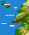 Cliffs of moher.png 442 × 530; 246 KB
-
 County Sligo relief location map (cropped).png 256 × 245; 64 KB
-
 Donegalbaysatmap.jpg 856 × 666; 375 KB
-
 Geo-politic-Ireland.jpg 300 × 380; 30 KB
-
 Icone irlande.png 97 × 124; 20 KB
-
 Ireland (1982).jpg 982 × 1,230; 253 KB
-
 Ireland 1173.jpg 850 × 1,080; 180 KB
-
 Ireland geographical map.png 150 × 190; 50 KB
-
 Ireland in Irish.jpg 676 × 815; 136 KB
-
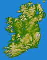
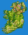
 Ireland relief location map.png 1,450 × 1,807; 1.55 MB
-
 Ireland road map.png 795 × 999; 316 KB
-
 Ireland-up.png 224 × 288; 81 KB
-
 Irish Sea – relief, ports, limits.tif 1,043 × 1,507; 4.5 MB
-
 IrishSeaReliefmap.png 1,043 × 1,507; 535 KB
-
 Irland karte.png 1,473 × 1,757; 1.25 MB
-
 Island of Ireland NASA.png 746 × 945; 684 KB
-
 Island of Ireland relief location map.png 1,450 × 1,807; 2.07 MB
-
 La2-demis-ireland.png 621 × 806; 108 KB
-
 Location map Ireland County Leitrim.png 229 × 285; 79 KB
-
 Mayomap.jpg 1,200 × 1,248; 415 KB
-
 Northdonmap.png 668 × 450; 462 KB
-
 Northeast Atlantic bathymetry.png 413 × 323; 347 KB
-
 Ptolemy's Ireland.png 454 × 580; 374 KB
-
 Reliefkarte Irland.png 2,997 × 3,724; 8.25 MB
-
 The international geography (1916) (14593098617).jpg 1,280 × 2,004; 277 KB
-
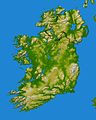
 Topography of Ireland.jpg 3,293 × 4,168; 3.86 MB
-
 Westislessatmap.png 622 × 628; 525 KB
-
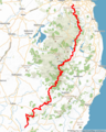 Wicklow Way Map.png 600 × 751; 423 KB
.jpg)


.jpg)
.jpg)
_(14580507139).jpg)


.png)


.jpg)


_(14593098617).jpg)


