Category:Old maps of Shropshire
Jump to navigation
Jump to search
Ceremonial counties of England: Bedfordshire · Berkshire · Buckinghamshire · Cambridgeshire · Cheshire · Cornwall · Cumbria · Derbyshire · Devon · Dorset · Durham · East Riding of Yorkshire · East Sussex · Essex · Gloucestershire · Greater London · Greater Manchester · Hampshire · Herefordshire · Hertfordshire · Isle of Wight · Kent · Lancashire · Leicestershire · Lincolnshire · Norfolk · North Yorkshire · Northamptonshire · Northumberland · Nottinghamshire · Oxfordshire · Rutland · Shropshire · Somerset · South Yorkshire · Staffordshire · Suffolk · Surrey · Warwickshire · West Midlands · West Sussex · West Yorkshire · Wiltshire · Worcestershire
City-counties: Bristol · City of London
Former historic counties: Cumberland · Huntingdonshire · Middlesex · Sussex · Westmorland · Yorkshire
Other former counties:
City-counties: Bristol · City of London
Former historic counties: Cumberland · Huntingdonshire · Middlesex · Sussex · Westmorland · Yorkshire
Other former counties:
Subcategories
This category has the following 4 subcategories, out of 4 total.
- Old county maps of Shropshire (11 F)
S
- Shropshire RJD 1914 (6 F)
Media in category "Old maps of Shropshire"
The following 20 files are in this category, out of 20 total.
-
 118 of '(Our own country. Descriptive, historical, pictorial.)' (11180206835).jpg 1,338 × 1,878; 812 KB
-

-
 179 of 'The History of Shavington, in the County of Salop' (11210110045).jpg 3,680 × 2,668; 1.09 MB
-
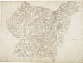
 17th Century map of Shropshire.jpg 3,456 × 2,592; 5.18 MB
-
 Ordnance Survey Drawings - Newport, Telford and Wrekin (OSD 208).jpg 4,000 × 2,384; 4.04 MB
-
 Ordnance Survey Drawings - Ironbridge, Telford and Wrekin (OSD 213).jpg 5,840 × 4,175; 3.86 MB
-
 Ordnance Survey Drawings - Market Drayton, Shropshire (OSD 209).jpg 5,133 × 3,908; 3.38 MB
-
 Ordnance Survey Drawings - Bishop's Castle, Shropshire (OSD 200).jpg 4,000 × 2,524; 4.96 MB
-
 Ordnance Survey Drawings - Welshpool (OSD 199).jpg 4,050 × 4,219; 3.76 MB
-
 Ordnance Survey Drawings - Cleobury Mortimer, Shropshire (OSD 206).jpg 5,586 × 4,027; 4.64 MB
-
 Ordnance Survey Drawings - Much Wenlock, Shropshire (OSD 207).jpg 4,000 × 2,776; 4.04 MB
-
 Ordnance Survey Drawings - Shrewsbury (OSD 320).jpg 5,807 × 3,460; 3.5 MB
-
 Ordnance Survey Drawings - Wem (OSD 326).jpg 5,284 × 3,581; 2.53 MB
-

-
 A new Map of the county of Salop divided into hundreds - btv1b8443190v.jpg 8,550 × 9,367; 11.23 MB
-
 Camlas ellesmere.png 712 × 1,002; 697 KB
-
 Dark lane village and communities.jpg 688 × 429; 179 KB
-
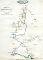
 Map of Dark Lane Area 1752.jpg 667 × 647; 109 KB
-
 Ordnance Survey Drawings - Oswestry (OSD 330).jpg 4,000 × 3,408; 4.95 MB
-
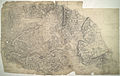
 TIMMINS(1899) p309 - Shropshire.jpg 2,928 × 3,344; 2.19 MB
%27_(11180206835).jpg)
.jpg)
.jpg)

.jpg)
.jpg)
.jpg)
.jpg)
.jpg)
.jpg)
.jpg)
.jpg)
.jpg)


.jpg)
_p309_-_Shropshire.jpg)