Category:Aerial photographs of Landkreis Starnberg
Jump to navigation
Jump to search
Urban districts (cities): Amberg · Ansbach · Aschaffenburg · Augsburg · Bamberg · Bayreuth · Coburg · Erlangen · Fürth · Hof · Ingolstadt · Kaufbeuren · Kempten · Landshut · Memmingen · Munich · Nuremberg · Passau · Regensburg · Rosenheim · Schwabach · Straubing · Weiden in der Oberpfalz · Würzburg
Deutsch: Luftaufnahmen aus dem Landkreis Starnberg.
Subcategories
This category has the following 2 subcategories, out of 2 total.
Media in category "Aerial photographs of Landkreis Starnberg"
The following 22 files are in this category, out of 22 total.
-
 Aerial image of the Ammersee (view from the south).jpg 5,500 × 3,400; 5.48 MB
-
 Aerial image of the Oberpfaffenhofen airfield.jpg 5,450 × 2,500; 5.6 MB
-
 Aerial image of the Pilsensee (view from the southwest).jpg 5,300 × 2,700; 5.48 MB
-
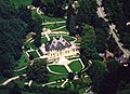
 Aerial image of the Possenhofen Castle (view from the south).jpg 4,700 × 3,000; 5.23 MB
-
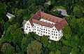 Aerial image of the Schloss Starnberg (view from the east).jpg 4,500 × 2,900; 5.59 MB
-
 Aerial image of the Schloss Starnberg and its garden (view from the southeast).jpg 4,300 × 2,400; 4.7 MB
-
 Aerial image of the Seefeld Castle (view from the southeast).jpg 3,900 × 2,700; 4.25 MB
-
 Aerial image of the Wörthsee (view from the southwest).jpg 5,200 × 2,900; 5.62 MB
-

-
 ETH-BIB-Starnberger See, Blick Richtung SO-Weitere-LBS MH02-33-0020.tif 4,926 × 3,284; 46.39 MB
-
 ETH-BIB-Starnberger See, Blick Richtung SO-Weitere-LBS MH02-33-0021.tif 4,928 × 3,285; 46.43 MB
-
 ETH-BIB-Starnberger See, Blick Richtung SO-Weitere-LBS MH02-33-0022.tif 4,922 × 3,283; 46.34 MB
-
 FlugplatzOberpfaffenhofen.jpg 4,000 × 3,000; 4.39 MB
-
 Görbelmoos Luftbild.jpg 5,344 × 3,561; 6.35 MB
-
 Luftaufnahme Herrsching am Ammersee.jpg 2,816 × 2,112; 560 KB
-
 Maistättenweiher Luftbild.jpg 5,378 × 3,584; 8.82 MB
-
 Oberpfaffenhofen (OBF - EDMO) AN0158896.jpg 1,024 × 728; 376 KB
-
 Palais Sonnenhof.jpg 2,692 × 1,950; 1.22 MB
-
 Perchting. Postkarte 1944.jpg 1,240 × 770; 696 KB
-
 Rundflug Oberbayern 02.jpg 3,456 × 2,592; 1.89 MB
-
 SIR-C-X-SAR-Oberpfaffenhofen.jpg 1,410 × 1,886; 723 KB
-
 Wuerm Starnberg.jpg 727 × 1,024; 566 KB
.jpg)

.jpg)
.jpg)
.jpg)
.jpg)
.jpg)
.jpg)


_AN0158896.jpg)


