Category:Aerial photographs of Landkreis Nürnberger Land
Jump to navigation
Jump to search
Urban districts (cities): Amberg · Ansbach · Aschaffenburg · Augsburg · Bamberg · Bayreuth · Coburg · Erlangen · Fürth · Hof · Kaufbeuren · Kempten · Landshut · Memmingen · Munich · Nuremberg · Passau · Regensburg · Rosenheim · Schwabach · Straubing · Weiden in der Oberpfalz · Würzburg
Deutsch: Luftaufnahmen aus dem Landkreis Nürnberger Land.
Subcategories
This category has the following 7 subcategories, out of 7 total.
Media in category "Aerial photographs of Landkreis Nürnberger Land"
The following 7 files are in this category, out of 7 total.
-
 Aerial image of Happurger See (view from the west).jpg 5,200 × 3,100; 7.25 MB
-
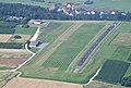
 Aerial image of the Altdorf-Hagenhausen gliding site.jpg 4,200 × 2,804; 4.4 MB
-
 Aerial image of the Hersbruck gliding site.jpg 4,600 × 3,500; 7.1 MB
-
 Aerial image of the Lauf-Lillinghof airfield.jpg 4,950 × 3,350; 4.84 MB
-
 Burg Hohenstein 20190706.jpg 4,254 × 2,637; 4.59 MB
-
 LuftaufnahmeLaipersdorf03102013bearb.JPG 4,592 × 3,056; 9.99 MB
-
 Osternohe-Luftbild.jpg 4,000 × 2,250; 7.82 MB
.jpg)


