Category:Aerial photographs of Landkreis Dachau
Jump to navigation
Jump to search
Urban districts (cities): Amberg · Ansbach · Aschaffenburg · Augsburg · Bamberg · Bayreuth · Coburg · Erlangen · Fürth · Hof · Kaufbeuren · Kempten · Landshut · Memmingen · Munich · Nuremberg · Passau · Regensburg · Rosenheim · Schwabach · Straubing · Weiden in der Oberpfalz · Würzburg
Deutsch: Luftaufnahmen aus dem Landkreis Dachau.
Subcategories
This category has only the following subcategory.
Media in category "Aerial photographs of Landkreis Dachau"
The following 14 files are in this category, out of 14 total.
-
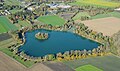
 Aerial image of Karlsfelder See.jpg 3,400 × 2,700; 4.33 MB
-
 Aerial image of the Altomünster airfield.jpg 4,700 × 3,100; 7.08 MB
-
 Aerial image of the Altstetten airfield.jpg 5,300 × 2,900; 6.02 MB
-
 Aerial image of the Dachau palace (view from the southwest).jpg 4,400 × 2,400; 4.16 MB
-
 Aerial image of the Dachau palace and court garden (view from the southwest).jpg 3,800 × 2,600; 4.19 MB
-
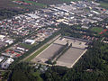
 Aerial image of the Dachau-Gröbenried airfield.jpg 5,300 × 3,300; 5.93 MB
-
 Aerial image of Waldschwaigsee (view from the southeast).jpg 3,700 × 2,200; 4.56 MB
-
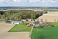
 Aerial view of Feldgeding, Germany.jpg 3,648 × 2,432; 2.16 MB
-
 Dachau Gedenkstätte Aerial.jpg 1,180 × 885; 411 KB
-
 Kappelhof Luftbild.jpg 3,656 × 2,437; 2.56 MB
-
 Kz-gedenkstätte-dachau.jpg 2,308 × 1,732; 3.48 MB
-
 Lauterbach (Bergkirchen) (31432181348).jpg 6,240 × 4,160; 22.71 MB
-
 Lindach Luftbild.jpg 4,155 × 2,770; 3.61 MB
-
 Upper Bavaria.jpg 1,515 × 1,574; 737 KB


.jpg)
.jpg)

.jpg)


_(31432181348).jpg)

