Category:Aerial photographs of Landkreis Hof
Jump to navigation
Jump to search
Urban districts (cities): Amberg · Ansbach · Aschaffenburg · Augsburg · Bamberg · Bayreuth · Coburg · Erlangen · Fürth · Hof · Kaufbeuren · Kempten · Landshut · Memmingen · Munich · Nuremberg · Passau · Regensburg · Rosenheim · Schwabach · Straubing · Weiden in der Oberpfalz · Würzburg
Deutsch: Luftaufnahmen aus dem Landkreis Hof.
Subcategories
This category has only the following subcategory.
Media in category "Aerial photographs of Landkreis Hof"
The following 2 files are in this category, out of 2 total.
-
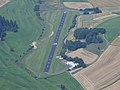 Aerial image of the Ottengrüner Heide airfield.jpg 4,000 × 3,000; 3.02 MB
-
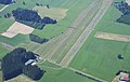 Aerial image of the Zell-Haidberg airfield.jpg 5,200 × 3,300; 5.24 MB

