Category:Aerial photographs of Landkreis Amberg-Sulzbach
Jump to navigation
Jump to search
Urban districts (cities): Amberg · Ansbach · Aschaffenburg · Augsburg · Bamberg · Bayreuth · Coburg · Erlangen · Fürth · Hof · Kaufbeuren · Kempten · Landshut · Memmingen · Munich · Nuremberg · Passau · Regensburg · Rosenheim · Schwabach · Straubing · Weiden in der Oberpfalz · Würzburg
Subcategories
This category has only the following subcategory.
Media in category "Aerial photographs of Landkreis Amberg-Sulzbach"
The following 11 files are in this category, out of 11 total.
-
 Aerial image of Burg Sulzbach (view from the southeast).jpg 3,700 × 3,000; 4.08 MB
-
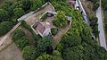
 Aerial image of Schloss Ebermannsdorf (view from the southeast).jpg 2,900 × 2,200; 4.12 MB
-
 Aerial image of Schloss Neidstein (view from the southeast).jpg 4,400 × 2,500; 7.08 MB
-
 Aerial image of the Burg Dagestein (view from the south).jpg 2,800 × 2,000; 2.2 MB
-
 Aerial image of the Fichtelbrunn gliding site.jpg 5,300 × 3,500; 6.98 MB
-
 Gunzendorf (Auerbach in der Oberpfalz) 001.jpg 6,016 × 3,384; 8.24 MB
-
 Kloster Michelfeld 003.jpg 6,016 × 3,384; 8.68 MB
-
 Ohrenbach 001.jpg 6,016 × 3,384; 8.94 MB
-
 Ortlesbrunn 001.jpg 6,016 × 3,384; 8.21 MB
-
 Schloss in Haunritz.jpg 557 × 536; 150 KB
-
 Schweppermannsburg1.jpg 4,000 × 2,250; 4 MB
.jpg)
.jpg)
.jpg)
.jpg)

_001.jpg)


