Category:1948 U.S. presidential election maps
Jump to navigation
Jump to search
Subcategories
This category has the following 2 subcategories, out of 2 total.
Media in category "1948 U.S. presidential election maps"
The following 8 files are in this category, out of 8 total.
-
 1948 Electoral Map.png 1,182 × 635; 188 KB
-
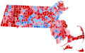 1948 Presidential Election in Massachusetts By Municipality.svg 810 × 502; 182 KB
-
 1948FicElectionMap.png 590 × 329; 23 KB
-
 1948RepublicanPartyPresidentialPrimaries.svg 1,020 × 593; 83 KB
-
 ElectoralCollege1948-Large.png 1,182 × 635; 108 KB
-
 ElectoralCollege1948.svg 1,020 × 593; 25 KB
-
 NYC Presidential Election Results 1948.svg 535 × 530; 799 KB
-
 Vermont Presidential Election Results 1948 by Municipality.svg 810 × 810; 106 KB


