Category:1924 U.S. presidential election maps
Jump to navigation
Jump to search
Subcategories
This category has the following 2 subcategories, out of 2 total.
Media in category "1924 U.S. presidential election maps"
The following 7 files are in this category, out of 7 total.
-
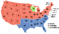
 1924 Electoral Map.png 1,182 × 635; 179 KB
-
 1924 Presidential Election in Massachusetts By Municipality.svg 810 × 502; 186 KB
-
 1924 US Presidential Election in Florida by county.svg 800 × 769; 2.06 MB
-
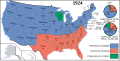 Electoral College 1924.svg 1,182 × 593; 247 KB
-
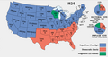 ElectoralCollege1924-Large.png 1,182 × 635; 101 KB
-
 ElectoralCollege1924.svg 1,020 × 593; 25 KB
-
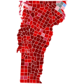 Vermont Presidential Election Results 1924 by Municipality.svg 810 × 810; 106 KB


