Category:1964 U.S. presidential election maps
Jump to navigation
Jump to search
Subcategories
This category has the following 2 subcategories, out of 2 total.
Media in category "1964 U.S. presidential election maps"
The following 18 files are in this category, out of 18 total.
-
 1964 Democratic presidential primaries.JPG 640 × 570; 39 KB
-
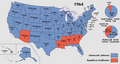
 1964 Electoral Map.png 1,182 × 635; 171 KB
-

-
 1964 Presidential Election in Massachusetts By Municipality.svg 810 × 502; 182 KB
-
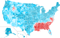
 1964 Presidential Election, Results by Congressional District.png 1,516 × 983; 83 KB
-
 1964DemocraticPresidentialPrimaries.svg 959 × 593; 113 KB
-
 1964RepublicanPresidentialPrimaries.png 640 × 640; 64 KB
-
 1964RepublicanPresidentialPrimaries.svg 959 × 593; 86 KB
-
 1968DemocraticPresidentialPrimaries.png 858 × 584; 16 KB
-
 ElectoralCollege1964-ModernColors-Large.png 1,182 × 635; 90 KB
-
 ElectoralCollege1964.svg 1,020 × 593; 28 KB
-
 Hawaii 1964.png 2,435 × 1,351; 14 KB
-
 Maine Presidential Results 1964 by Municipality.svg 810 × 810; 3.03 MB
-
 Map of USA presidential elections 1964.PNG 280 × 183; 13 KB
-
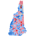 New Hampshire Presidential Results 1964 by Municipality.svg 810 × 810; 100 KB
-

-
 U.S. 1960 to 1964 presidential election swing.svg 555 × 352; 1.42 MB
-
 Vermont Presidential Election Results 1964 by Municipality.svg 810 × 810; 106 KB


