Category:SVG maps of Indiana
Jump to navigation
Jump to search
States of the United States: Alabama · Alaska · Arizona · Arkansas · California · Colorado · Connecticut · Delaware · Florida · Georgia · Hawaii · Idaho · Illinois · Indiana · Iowa · Kansas · Kentucky · Louisiana · Maine · Maryland · Massachusetts · Michigan · Minnesota · Mississippi · Missouri · Montana · Nebraska · Nevada · New Hampshire · New Jersey · New Mexico · New York · North Carolina · North Dakota · Ohio · Oklahoma · Oregon · Pennsylvania · Rhode Island · South Carolina · South Dakota · Tennessee · Texas · Utah · Vermont · Virginia · Washington · West Virginia · Wisconsin · Wyoming – Washington, D.C.
American Samoa · Guam · Northern Mariana Islands · Puerto Rico – Navassa Island · Palmyra Atoll
American Samoa · Guam · Northern Mariana Islands · Puerto Rico – Navassa Island · Palmyra Atoll
Subcategories
This category has only the following subcategory.
Media in category "SVG maps of Indiana"
The following 22 files are in this category, out of 22 total.
-
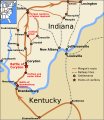 Battle of Corydon with Morgan's Raid in southern Indiana.svg 601 × 692; 441 KB
-
 Black Swamp.svg 538 × 401; 315 KB
-
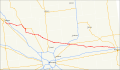 Indiana 38 map.svg 1,475 × 860; 833 KB
-
 Indiana counties and cities with domestic partnerships.svg 266 × 420; 57 KB
-

-
 Indiana counties by race.svg 267 × 422; 21 KB
-
 Indiana county map, cb 500k.svg 810 × 810; 27 KB
-
 Indiana in United States (US48).svg 1,181 × 731; 2.36 MB
-
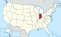 Indiana in United States.svg 1,181 × 731; 3.46 MB
-
 Indiana Indian treaties.svg 2,887 × 4,423; 313 KB
-
 Indiana Klan percentage.svg 1,115 × 756; 234 KB
-
 Indiana Köppen.svg 900 × 1,512; 584 KB
-
 Indiana racial and ethnic map.svg 266 × 420; 19 KB
-
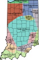
 Indiana State Senate Map Current.svg 3,436 × 2,019; 860 KB
-
 Indianapolis numbered routes labeled.svg 1,624 × 1,548; 827 KB
-
 LGBT flag map of Indiana.svg 621 × 973; 14 KB
-
 Map of USA IN.svg 286 × 186; 167 KB
-
 Nanfan-es.svg 512 × 396; 1.86 MB
-
 Nanfan.svg 512 × 396; 1.48 MB
-
 NRHP Indiana Map.svg 765 × 990; 9.67 MB
-
 Physiographic regions indiana.svg 515 × 870; 86 KB
-
 USA Indiana relief location map.svg 776 × 1,200; 1.38 MB


.svg)


