
Category:20th-century maps of the Isle of Wight
Ceremonial counties of England: Bedfordshire · Berkshire · Buckinghamshire · Cambridgeshire · Cheshire · Cornwall · Derbyshire · Devon · Dorset · Durham · Essex · Gloucestershire · Greater London · Hampshire · Herefordshire · Hertfordshire · Isle of Wight · Kent · Lancashire · Leicestershire · Lincolnshire · Norfolk · Northamptonshire · Northumberland · Nottinghamshire · Oxfordshire · Rutland · Shropshire · Somerset · Staffordshire · Suffolk · Surrey · Warwickshire · Wiltshire · Worcestershire
City-counties:
Former historic counties: Cumberland · Middlesex · Sussex · Westmorland · Yorkshire
Other former counties:
City-counties:
Former historic counties: Cumberland · Middlesex · Sussex · Westmorland · Yorkshire
Other former counties:
Media in category "20th-century maps of the Isle of Wight"
The following 17 files are in this category, out of 17 total.
-
 A history of Hampshire and the Isle of Wight (Page 540) BHL20977817.jpg 2,274 × 3,380; 1.14 MB
-
 A history of Hampshire and the Isle of Wight (Page 541) BHL20977818.jpg 2,274 × 3,380; 1,024 KB
-
 Map from Isle of Wight (1908) John Bartholomew & Co..jpg 7,544 × 5,134; 10.7 MB
-
 Ordnance Survey One-Inch Sheet 141 Southampton Portsmouth and Isle of Wight, Published 1936.jpg 16,475 × 12,403; 22.84 MB
-

-

-

-
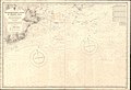 Admiralty Chart No 2012 St Catherines Point to Selsey Bill, Published 1941.jpg 16,234 × 11,120; 45.17 MB
-
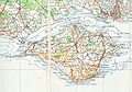 IsleofWightmap 1945needs fix.jpg 4,528 × 3,152; 1.66 MB
-
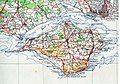 IsleofWightmap 1945.jpg 2,264 × 1,576; 996 KB
-
 Ordnance Survey One-Inch Sheet 180 The Solent, Published 1945.jpg 8,163 × 9,570; 10.68 MB
-
 Ordnance Survey Sheet SZ 68 (40 68) Bembridge, Published 1948.jpg 7,616 × 8,862; 14.19 MB
-
 Admiralty Chart No 2450 Anvil Point to Beachy Head, Published 1954.jpg 17,475 × 11,269; 14.28 MB
-
 Admiralty Chart No 2793 Cowes Harbour to River Medina, Published 1965.jpg 11,055 × 16,215; 69.57 MB
-
 Admiralty Chart No 2045 Christchurch to Owers, Published 1966.jpg 17,603 × 11,284; 62.07 MB
-
 Ordnance Survey One-Inch Sheet 180 The Solent, Published 1966.jpg 8,160 × 9,943; 10.51 MB
-
 Ordnance Survey One-Inch Sheet 180 The Solent, Published 1971.jpg 10,957 × 13,121; 42.48 MB
_BHL20977817.jpg)
_BHL20977818.jpg)
_John_Bartholomew_%26_Co..jpg)

.jpg)
.jpg)
.jpg)


_Bembridge,_Published_1948.jpg)


