Category:20th-century maps of Yorkshire
Jump to navigation
Jump to search
Ceremonial counties of England: Bedfordshire · Berkshire · Buckinghamshire · Cambridgeshire · Cheshire · Cornwall · Derbyshire · Devon · Dorset · Durham · Essex · Gloucestershire · Greater London · Hampshire · Herefordshire · Hertfordshire · Isle of Wight · Kent · Lancashire · Leicestershire · Lincolnshire · Norfolk · Northumberland · Nottinghamshire · Oxfordshire · Shropshire · Somerset · Staffordshire · Suffolk · Warwickshire · Wiltshire · Worcestershire
City-counties:
Former historic counties: Cumberland · Middlesex · Sussex · Westmorland · Yorkshire
Other former counties:
City-counties:
Former historic counties: Cumberland · Middlesex · Sussex · Westmorland · Yorkshire
Other former counties:
Media in category "20th-century maps of Yorkshire"
The following 7 files are in this category, out of 7 total.
-
 Baynard Castle, Cottingham, OS map, 1910.jpg 730 × 639; 186 KB
-

-
 Admiralty Chart No 1882 Bridlington Bay, Published 1894, New Edition 1915.jpg 10,885 × 8,173; 30.58 MB
-
 Ordnance Survey One-Inch Sheet 27 York, Published 1924.jpg 11,913 × 8,924; 9.24 MB
-
 Ordnance Survey One-inich Sheet 14 Darlington, Published 1925.jpg 12,177 × 8,896; 37.52 MB
-
 Baynard Castle, Cottingham, OS map, 1927.jpg 1,784 × 942; 560 KB
-
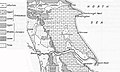 East Yorkshire Geology.jpg 646 × 386; 158 KB


