Category:1930s maps of Europe
Jump to navigation
Jump to search
Temperate regions: North America · South America · Africa · Europe · Asia · Oceania – Polar regions: – Other regions:
Subcategories
This category has the following 46 subcategories, out of 46 total.
1
A
- 1930s maps of Austria (5 F)
B
- 1930s maps of Belarus (22 F)
- 1930s maps of Belgium (6 F)
C
- 1930s maps of the Caucasus (7 F)
D
F
G
I
- 1930s maps of Iceland (2 F)
- 1930s maps of Ireland (2 F)
L
N
P
R
- 1930s maps of Romania (7 F)
- 1930s maps of Russia (12 F)
S
T
U
Media in category "1930s maps of Europe"
The following 28 files are in this category, out of 28 total.
-
 1930 in Ukraine.png 436 × 307; 39 KB
-
 2014-GareCornavin-Hall2.jpg 2,592 × 1,944; 1.34 MB
-
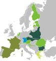
 Bloc of Agrarian Countries and Maniu Plan (Little Europe).svg 450 × 456; 423 KB
-
 International Agrarian Bureau.svg 2,670 × 2,880; 445 KB
-
 International Entente of Radical and Similar Democratic Parties.svg 2,670 × 2,880; 393 KB
-

-
-

-
-

-
 Map Albania 1930 - Touring Club Italiano CART-TRC-05.jpg 5,562 × 7,384; 5.79 MB
-
 Map Austria and the spartitions of Poland 1928-1940 - Touring Club Italiano CART-TRC-60.jpg 6,290 × 6,846; 4.53 MB
-
 Map Austria in the napoleonic age 1928-1940 - Touring Club Italiano CART-TRC-61.jpg 5,056 × 6,579; 3.63 MB
-
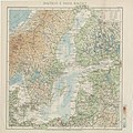 Map Baltic and Baltic countries 1930 - Touring Club Italiano CART-TRC-08.jpg 7,096 × 7,122; 16.92 MB
-
 Map Basilicata 1930 - Touring Club Italiano CART-TRC-02.jpg 7,485 × 5,562; 18.92 MB
-
 Map Belgio 1930 - Touring Club Italiano CART-TRC-06.jpg 5,478 × 4,490; 16.89 MB
-
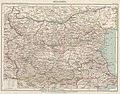 Map Bulgaria 1930 - Touring Club Italiano CART-TRC-07.jpg 6,482 × 5,074; 23.64 MB
-
 Map Europe around 560 AD - Touring Club Italiano CART-TRC-50 01.jpg 3,873 × 3,205; 1.52 MB
-
 Map Europe in 1660- Touring Club Italiano CART-TRC-51 01.jpg 3,853 × 3,195; 1.58 MB
-
 Map Europe in 1789- Touring Club Italiano CART-TRC-51 02.jpg 3,836 × 3,065; 1.53 MB
-
 Map Europe in 1810- Touring Club Italiano CART-TRC-52 01.jpg 3,787 × 3,209; 1.56 MB
-
 Map Europe in 1815- Touring Club Italiano CART-TRC-52 02.jpg 3,871 × 3,094; 1.56 MB
-
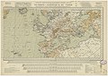
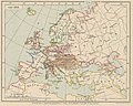
 Map Europe in 1914 1928-1940 - Touring Club Italiano CART-TRC-58 02.jpg 3,863 × 3,050; 1.58 MB
-
 Map Europe in 814- Touring Club Italiano CART-TRC-50 02.jpg 3,826 × 3,086; 1.51 MB
-
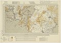
 Map Linguistic map of Europe 1928-1940 - Touring Club Italiano CART-TRC-29.jpg 7,491 × 6,356; 27.8 MB
-

-

-


.svg)


.jpg)
.jpg)
.jpg)
.jpg)
.jpg)