
Category:1930s maps of Spain
Subcategories
This category has the following 3 subcategories, out of 3 total.
- 1932 maps of Spain (2 F)
- 1937 maps of Spain (11 F)
- 1938 maps of Spain (11 F)
Media in category "1930s maps of Spain"
The following 16 files are in this category, out of 16 total.
-
 Mapa provincial Málaga 1935.jpg 11,016 × 7,777; 8.81 MB
-
 1936 - Regions i comarques 1936.jpg 6,523 × 9,000; 6.49 MB
-
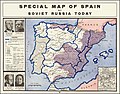 1937 Special Map of Spain by Soviet Russia Today.jpg 12,957 × 10,147; 37.43 MB
-
 MapaChozas.jpg 2,365 × 1,409; 725 KB
-
 Atlas brigadas internacionales (15-2) 58.revisado.png 772 × 873; 907 KB
-
 Corpo Truppe Volontarie 08.jpg 3,285 × 4,756; 11.04 MB
-
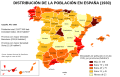
 Densidades de población en España (1930).png 784 × 537; 172 KB
-
 Densidades de población en España (1930).svg 568 × 387; 1.49 MB
-
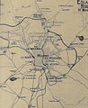 Enlaces ferroviarios de Madrid (1933).jpg 1,126 × 1,380; 438 KB
-
 General map of the Spanish Civil War (1936–39).svg 938 × 810; 1.77 MB
-
 Guerra Civil Española.svg 722 × 623; 2.34 MB
-
 Map of the Spanish Civil War in February 1939.png 900 × 725; 155 KB
-
 Map of the Spanish Civil War in March 1937.png 900 × 725; 158 KB
-
 Province de Guipuzcoa (Espagne) - btv1b84602398.jpg 7,892 × 7,944; 7.94 MB
-
 Territorios de la Segunda República Española-variante.svg 4,950 × 7,500; 1.73 MB
-
 Valladolid 1931.jpg 1,743 × 2,799; 1.38 MB


_58.revisado.png)

.png)
.svg)
.jpg)
.svg)


_-_btv1b84602398.jpg)

