Category:NYPL maps
Jump to navigation
Jump to search
This category has been populated as part of a batch upload of maps from the New York Public Library on-line archives. Refer to Batch uploading/NYPL Maps for details of the upload project.
Potential bugs:
- If an image appears to have a magenta or white overlay, this will be due to an inappropriate colour profile embedded in the file. To restore the image, it needs to be loaded into a tool like Photoshop and resaved as an identical tiff but with colour profiles removed (normally a save option).
- Due to template limitations of the GWToolset, uploads may have odd text formatting showing several semi-colons before the information box. This is being corrected by a house-keeping script post-upload and should be ignored.
- Tiffs larger than 50 megapixels will not have thumbnails rendered on Commons at the current time. Any of interest should be duplicated as jpeg versions which can be saved at the identical resolution but should have thumbnails automatically created. Please link the jpegs and tiffs to each other by updating the other_versions parameter in the information template.
If you notice other issues, please raise them on the batch upload project page linked above.
Subcategories
This category has the following 15 subcategories, out of 15 total.
Media in category "NYPL maps"
The following 200 files are in this category, out of 3,625 total.
(previous page) (next page)-
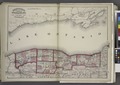 "Niagara, Orleans, Genesee, Monroe, and Wayne counties" NYPL1575787.tiff 7,106 × 5,044; 102.55 MB
-
-

-

-

-
 "Onondaga, Cortland, Broome, Madison, and Chenango Counties" NYPL1575789.tiff 5,006 × 6,334; 90.72 MB
-

-

-
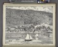
 "Residence and Farm of W.H. Chase, Union Springs, Cayuga Co. N.Y." NYPL1583083.tiff 6,630 × 5,414; 102.7 MB
-
 "St. Lawrence, Franklin, Clinton, and Essex" NYPL1575785.tiff 7,106 × 5,044; 102.55 MB
-
 "St. Peter's and Paul's Church. Williamsville, Erie Co., New York." NYPL1576118.tiff 5,428 × 6,508; 101.07 MB
-
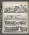 "Stock Farm and Residence of L.N. Close, Township of Leoyard, Cayuga Co. N.Y. " NYPL1583076.tiff 5,414 × 6,606; 102.33 MB
-

-

-
-

-
-

-

-
 "We the subscribers ..." (copy) NYPL1404002.tiff 4,384 × 6,299; 79.02 MB
-

-
 16A - N.Y. City (Aerial Set). NYPL1532618.tiff 6,997 × 1,968; 39.41 MB
-
-
 64 Central Park Lots, New York City. - map by Muller, A. H. -1869 NYPL2015216.tiff 5,973 × 4,872; 83.29 MB
-
-

-
-
 A chart od Iland of NEW FOUND LAND with paticular harbors atlarge NYPL1640629.tiff 7,230 × 5,428; 112.28 MB
-
 A chart of coast of ANGOLA from R Ambris to Mount Negro NYPL1640663.tiff 7,230 × 5,428; 112.28 MB
-
 A chart of coast of BARBARY from C. Bajadore to the Golfe of St. Anne NYPL1640672.tiff 7,230 × 5,428; 112.28 MB
-

-
 A chart of coast SWEDEN from Oeland to Stockholm NYPL1640731.tiff 7,230 × 5,428; 112.28 MB
-
 A chart of coasts of CIMBEBAS and CAFFARIA NYPL1640662.tiff 7,230 × 5,428; 112.28 MB
-
 A chart of coasts of GABON, LOANGO and CONGO from C. St. Iohn to the River Ambris NYPL1640664.tiff 7,230 × 5,428; 112.28 MB
-

-

-

-

-

-
-

-

-

-
-
 A chart of EEMS ELVE, Wefer, Eyder and Hever. With the Holy Island NYPL1640697.tiff 7,230 × 5,428; 112.28 MB
-

-
 A chart of JUTLAND and the Islands of Omtren NYPL1640696.tiff 7,230 × 5,428; 112.28 MB
-

-

-

-

-
-
-

-
 A chart of NORWAY from High Land of Horrel to Momendael with Liet of Dronten NYPL1640720.tiff 7,230 × 5,428; 112.28 MB
-
 A chart of PRUSSIA and Coerland from Rygshead to Der Winda NYPL1640728.tiff 7,230 × 5,428; 112.28 MB
-
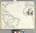
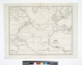 A chart of the Atlantic Ocean. I sheet. NYPL434478.tiff 5,899 × 4,680; 78.99 MB
-
-
 A Chart of the Atlantic or Western Ocean - Jones, sc. NYPL433947.tiff 5,648 × 4,208; 68 MB
-
-
 A Chart of the Atlantic or Western Ocean. NYPL465943.tiff 5,339 × 4,725; 72.18 MB
-
 A chart of the Atlantick Ocean from Buttons Island to Port Royall. NYPL484218.tiff 4,978 × 4,414; 62.87 MB
-

-

-
 A chart of the bay of BISCAY from the Isle Ouessant to Cape Finisterre NYPL1640595.tiff 7,230 × 5,428; 112.28 MB
-
 A chart of the BAY OF GALLOWAY and RIVER SHANNON NYPL1640581.tiff 7,230 × 5,428; 112.28 MB
-
 A chart of the BELT and SOUND NYPL1640725.tiff 7,230 × 5,428; 112.28 MB
-
 A chart of the BIGHT of BINNIN from Ningo Grande to R. Andoney NYPL1640666.tiff 7,230 × 5,428; 112.28 MB
-
 A chart of the CANARIE and MADERA Islands NYPL1640659.tiff 7,230 × 5,428; 112.28 MB
-
 A chart of the CARIBE ILANDS NYPL1640618.tiff 7,230 × 5,428; 112.28 MB
-
-
 A chart of the coast of BARBARIA with the Western, Canaria and Cape de Verd, Isles NYPL1640676.tiff 7,230 × 5,428; 112.28 MB
-
 A chart of the coast of GUINEA from cape de Verd to cape Bona Esperanca NYPL1640669.tiff 7,230 × 5,428; 112.28 MB
-

-

-
 A chart of the east coast of Scotland. NYPL1640567.tiff 7,230 × 5,428; 112.28 MB
-
 A chart of the EAST-SEA NYPL1640726.tiff 7,230 × 5,428; 112.28 MB
-

-

-
 A chart of the GOLD COAST in GUINEA from the River St. John to the River Volta NYPL1640667.tiff 7,230 × 5,428; 112.28 MB
-

-
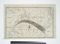
 A chart of the Gulf Stream - James Poupard, sculp. NYPL430369.tiff 7,230 × 5,428; 112.28 MB
-
-
 A chart of the Island of MAURITIUS NYPL1640653.tiff 7,230 × 5,428; 112.28 MB
-
 A chart of THE ISLES off CAPE-VERD NYPL1640658.tiff 7,230 × 5,428; 112.28 MB
-

-
 A chart of the NORTH SEA NYPL1640558.tiff 7,230 × 5,428; 112.28 MB
-
 A chart of the NORTH-WEST coast of IRELAND from LOUGH SWILLY to SLYNE HEAD NYPL1640580.tiff 7,230 × 5,428; 112.28 MB
-
-
 A chart of the sea coast from ENGLAND to the STREIGHTS NYPL1640593.tiff 7,230 × 5,428; 112.28 MB
-
-
 A chart of the sea coast of ITALY, SICILY and part of BARBARY NYPL1640684.tiff 7,230 × 5,428; 112.28 MB
-

-

-

-

-

-

-

-
-
 A chart of the Sea-Coast of ZEALAND from Walcheren to the Macs NYPL1640701.tiff 7,230 × 5,428; 112.28 MB
-

-
 A chart of the shoulds and rivers of GAMBIA NYPL1640670.tiff 7,230 × 5,428; 112.28 MB
-

-
 A chart of the SOUTH SEA Texel and Flieftream with Amelander gat NYPL1640699.tiff 7,230 × 5,428; 112.28 MB
-
 A chart of the straits of BABELMANDELL and MOHA NYPL1640652.tiff 7,230 × 5,428; 112.28 MB
-
 A chart of the STRAITS of GIBRALTER NYPL1640695.tiff 7,230 × 5,428; 112.28 MB
-
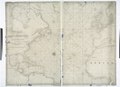
 A chart of the West Indias from Cap Cod to ye River Oronoque - by John Seller. NYPL433739.tiff 4,732 × 4,283; 58.01 MB
-

-
 A chart of the West Indies, from the latest marine journals and surveys. NYPL1404013.tiff 6,299 × 5,248; 94.6 MB
-
-
 A chart of the WHITE SEA with the River Dwina NYPL1640715.tiff 7,230 × 5,428; 112.28 MB
-

-

-

-

-

-

-

-
 A correct map of Virginia. NYPL433675.tiff 6,300 × 5,248; 94.61 MB
-
 A description of the coast FLANDERS from the Island Walcheren to Calice NYPL1640700.tiff 7,230 × 5,428; 112.28 MB
-

-
 A draught of Cape Bona ESPERANCA NYPL1640656.tiff 7,230 × 5,428; 112.28 MB
-
 A draught of New York and Perthamboy Harbour. NYPL434401.tiff 4,374 × 3,791; 47.45 MB
-
 A draught of New York from the hook to New York Town. NYPL434958.tiff 4,298 × 3,793; 46.65 MB
-
 A draught of New York from the hook to New York Town. NYPL481128.tiff 3,960 × 5,555; 62.94 MB
-
 A draught of New York from the hook to New York Town. NYPL484209.tiff 4,958 × 4,615; 65.47 MB
-
 A draught of New York from the Hook to New York Town. NYPL484915.tiff 4,605 × 3,652; 34.43 MB
-
 A draught of the coast of Africa from the streights mouth to Cape Bona Esprance NYPL1640674.tiff 5,428 × 7,230; 112.28 MB
-
 A draught of the coast of NEW HOLLAND and parts Adjacent NYPL1640631.tiff 5,428 × 7,230; 112.28 MB
-

-
 A draught of the south part of AFRICA from cape Bona Esperance to Delagoa NYPL1640655.tiff 7,230 × 5,428; 112.28 MB
-
 A draught of Virginia from the Capes to York in York River .... NYPL481129.tiff 6,082 × 4,288; 74.62 MB
-
-

-

-
 A general map of North America - from the latest observations - J. Lodge sculp. NYPL433898.tiff 3,686 × 3,742; 39.47 MB
-

-
-
-
-
 A generall chart from ENGLAND to cape Bona Espranca with the coast of BRASILE NYPL1640675.tiff 5,428 × 7,230; 112.28 MB
-

-
 A generall chart of the South Sea ... NYPL481132.tiff 7,230 × 5,428; 112.28 MB
-
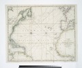
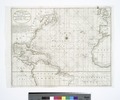
 A Generall chart of the Western Ocean. NYPL434470.tiff 5,451 × 4,648; 72.53 MB
-
 A generall chart of the Western Ocean. NYPL481126.tiff 3,920 × 5,515; 61.86 MB
-

-

-
 A large chart of part of the coast of COREMANDELL from Point Pedro to Armegon NYPL1640643.tiff 7,230 × 5,428; 112.28 MB
-
 A large chart of part of the coast of GUZARATT and INDIA from Diu head to Bombay NYPL1640649.tiff 7,230 × 5,428; 112.28 MB
-
 A large chart of PORT MAON on the ISLAND MINORK in the Meditteranean NYPL1640689.tiff 7,230 × 5,428; 112.28 MB
-
 A large chart of the BAY OF BISCAY NYPL1640602.tiff 5,428 × 7,230; 112.28 MB
-
 A large chart of the Island ANTEGUA NYPL1640616.tiff 7,230 × 5,428; 112.28 MB
-
 A large draft of SOUTH CAROLINA from cape Roman to Port Royall NYPL1640623.tiff 7,230 × 5,428; 112.28 MB
-

-
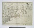
 A large draught of New England, New York and Long Island; Boston Harbour. NYPL481135.tiff 7,230 × 5,428; 112.28 MB
-
 A large draught of parrt of the coast of INDIA from Bombay to Bassalore NYPL1640647.tiff 7,230 × 5,428; 112.28 MB
-
 A large draught of the coast of ARABIA from Maculla to Dofar NYPL1640651.tiff 7,230 × 5,428; 112.28 MB
-

-
 A Large Draught of the DOWNES NYPL1640571.tiff 7,230 × 5,428; 112.28 MB
-

-
 A large draught of the GOLF of PERSIA NYPL1640650.tiff 7,230 × 5,428; 112.28 MB
-

-

-
 A large draught of the ISLE of WIGHT and OWERS NYPL1640573.tiff 7,230 × 5,428; 112.28 MB
-
 A large draught of the MALLABAR COAST from bassalore to cape comaroone NYPL1640646.tiff 7,230 × 5,428; 112.28 MB
-
-
 A large draught of the south part of BORNEO NYPL1640633.tiff 7,230 × 5,428; 112.28 MB
-
 A large draught Port Royall harbour in CAROLINA NYPL1640622.tiff 5,428 × 7,230; 112.28 MB
-

-
 A Map of Africa drawn and engraved from D'Anville... NYPL1995946.tiff 6,452 × 4,788; 88.41 MB
-
-
 A map of Brazil, now called New Portugal. NYPL1404018.tiff 5,248 × 6,299; 94.6 MB
-
 A map of Caracas. NYPL1404015.tiff 6,299 × 5,248; 94.6 MB
-
 A Map of Carolana and of the River Meschacebe etc NYPL434393.tiff 4,932 × 4,272; 60.29 MB
-
 A map of Connecticut. NYPL1567523.tiff 6,598 × 5,428; 102.47 MB
-
 A map of Florida and ye Great Lakes of Canada - by Robt. Morden. NYPL433721.tiff 1,293 × 1,404; 5.2 MB
-
 A map of Ireland according to the best authorities. NYPL1404023.tiff 6,299 × 5,248; 94.6 MB
-
 A map of Kentucky, drawn from actual observations by John Filson. NYPL1567531.tiff 5,428 × 7,230; 112.28 MB
-

-

-
 A map of Massachusets (sic) from the best authorities. NYPL1567521.tiff 6,598 × 5,428; 102.47 MB
-
 A map of New England and New York - F. Lamb sculp. NYPL434826.tiff 5,248 × 6,075; 91.22 MB
-

-
 A map of New Hampshire. NYPL1567520.tiff 5,428 × 6,598; 102.47 MB
-
 A map of New Iarsey - by John Seller. NYPL433742.tiff 4,459 × 4,272; 54.51 MB
-
 A map of New Jersey, from the best authorities. NYPL1567525.tiff 5,428 × 6,598; 102.47 MB
-
 A map of Newfoundland. NYPL1567517.tiff 5,428 × 6,598; 102.47 MB
-

-

-
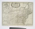
 A map of North Carolina, from the best authorities. NYPL1567532.tiff 7,230 × 5,428; 112.28 MB
-
-
 A map of Pennsylvania, from the best authorities. NYPL1567526.tiff 6,598 × 5,428; 102.47 MB
-
 A map of Philadelphia and parts adjacent - by N. Scull and G. Heap. NYPL433956.tiff 4,928 × 5,147; 72.57 MB
-
 A map of Philadelphia and parts adjacent - by N. Scull and G. Heap. NYPL434703.tiff 4,600 × 4,963, 2 pages; 65.43 MB
-
 A map of Rhode Island. NYPL1567522.tiff 5,428 × 6,598; 102.47 MB
-
 A map of South America and the adjacent islands, 1794. NYPL1567536.tiff 6,598 × 5,428; 102.47 MB
-
 A map of South Carolina, from the best authorities. NYPL1567534.tiff 7,230 × 5,428; 112.28 MB
-
-
.png)


