File:A chart of Delaware Bay and River - containing a full and exact description of the shores, creeks, harbours, soundings, shoals, sands, and bearings of the most considerable land marks etc etc - NYPL433943.tiff
Jump to navigation
Jump to search

Size of this JPG preview of this TIF file: 753 × 600 pixels. Other resolutions: 302 × 240 pixels | 603 × 480 pixels | 965 × 768 pixels | 1,280 × 1,019 pixels | 2,560 × 2,038 pixels | 2,846 × 2,266 pixels.
Original file (2,846 × 2,266 pixels, file size: 18.46 MB, MIME type: image/tiff)
Captions
Captions
Add a one-line explanation of what this file represents
Summary[edit]
| Description |
English: A chart of Delaware Bay and River : containing a full and exact description of the shores, creeks, harbours, soundings, shoals, sands, and bearings of the most considerable land marks etc etc / faithfully coppied [sic] from that published at Philadelphia by Joshua Fisher, together with the tide table from the Capes to Philadelphia, and the set of the tide on the several quarters of the flood and ebb.; Lawrence H. Slaughter Collection of English maps, charts, globes, books and atlases / Charts and maps Subtitle from scan: (Map Div. 00-498) [File with Delaware parts] Delaware Bay 1776 |
|||||||||||||||||||||||||||||||||||||||
| Notes | Depths shown by soundings. ''Note 2.'') Includes tide-table and list of pilots and masters of vessels who have recommended the map. ''Note 3.'') Lawrence H. Slaughter Collection ; 603. ''Note 4.'') National Endowment for the Humanities Grant for Access to Early Maps of the Middle Atlantic Seaboard. ''Note 5.'') NYPL copy has ms. note on verso: 10. ''Note 6.'') Oriented with north to right. ''Note 7.'') Shows Cape Henlopen as Cape James, to the north of "C. Hinlopen." ''Note 8.'') Shows various ship channels from the mouth of Delaware Bay to Philadelphia, Pa. | |||||||||||||||||||||||||||||||||||||||
| Catalogue call number | Map Div. 00-498 [LHS 603] | |||||||||||||||||||||||||||||||||||||||
| Date | ||||||||||||||||||||||||||||||||||||||||
| Source |
http://digitalgallery.nypl.org/nypldigital/dgkeysearchdetail.cfm?imageID=433943
|
|||||||||||||||||||||||||||||||||||||||
| Author |
|
|||||||||||||||||||||||||||||||||||||||
| Permission (Reusing this file) |
From The Lionel Pincus & Princess Firyal Map Division. http://maps.nypl.org
|
|||||||||||||||||||||||||||||||||||||||
| Location | Stephen A. Schwarzman Building / The Lionel Pincus and Princess Firyal Map Division | |||||||||||||||||||||||||||||||||||||||
| Digital item published | 5-11-2006; updated 3-25-2011 | |||||||||||||||||||||||||||||||||||||||
| Digital ID | 433943 | |||||||||||||||||||||||||||||||||||||||

_the_sayer_family_of_richmond_(cropped).jpg)
The making of this file was supported by Wikimedia UK.
To see other files made with the support of Wikimedia UK, please see the category Supported by Wikimedia UK.
|
File history
Click on a date/time to view the file as it appeared at that time.
| Date/Time | Thumbnail | Dimensions | User | Comment | |
|---|---|---|---|---|---|
| current | 18:12, 1 June 2022 |  | 2,846 × 2,266 (18.46 MB) | Sebastian Wallroth (talk | contribs) | Cropped -26 % horizontally, 20 % vertically, rotated 90° using CropTool with precise mode. |
| 10:13, 2 May 2022 | 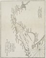 | 2,266 × 2,846 (18.46 MB) | Enyavar (talk | contribs) | Cropped 45 % horizontally, 47 % vertically using CropTool with lossless mode. | |
| 07:29, 20 April 2014 |  | 4,128 × 5,339 (63.06 MB) | Fæ (talk | contribs) | GWToolset:: Creating mediafile for Fæ. Tranche 2.229 |
You cannot overwrite this file.
File usage on Commons
The following 2 pages use this file: