Category:NYPL maps (over 50 megapixels)
Jump to navigation
Jump to search
Refer to Category talk:NYPL maps (over 50 megapixels) for a backlog dashboard, indicating progress of making jpeg versions available for these images which are too large a resolution tiff to render thumbnails.
Media in category "NYPL maps (over 50 megapixels)"
The following 200 files are in this category, out of 1,249 total.
(previous page) (next page)-
-
-
-
-

-

-
-
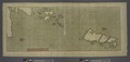
 A large draught of the coast of JAVA from Bantam Point to Batavia NYPL1640637.tiff 10,890 × 5,400; 168.27 MB
-
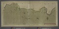
 A large draught of the Isle of Orkney and Shetland with the north part of SCOTLAND. NYPL1640561.tiff 11,310 × 5,400; 174.76 MB
-
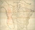 A map exhibiting all the new discoveries in the interior parts of North America. NYPL465250.tiff 8,909 × 7,687; 195.96 MB
-

-
-
-
-

-
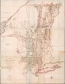
 A map of the Province of New York, with part of Pensilvania, and New England. NYPL434400.tiff 6,099 × 9,682; 168.96 MB
-
 A map of the Province of New York, with part of Pensilvania, and New England. NYPL484242.tiff 6,569 × 9,935; 186.72 MB
-

-

-

-
 A map of the state of Pennsylvania - by Reading Howell. NYPL434849.tiff 10,022 × 5,248; 150.48 MB
-

-

-

-

-

-
-

-

-
-

-

-
 Alagoa Ad Austrum NYPL1505078.tiff 8,144 × 7,780; 181.3 MB
-

-

-
 Angra op Tercera NYPL1504986.tiff 8,160 × 7,764; 181.28 MB
-
 Arx Nassovii. NYPL1505089.tiff 8,144 × 7,780; 181.3 MB
-
 Arx Principis Guiljelmi NYPL1505086.tiff 8,144 × 7,780; 181.3 MB
-
 Assemblage de l' atlas Suisse. NYPL3979935.tiff 8,984 × 6,732, 2 pages; 173.31 MB
-
 Astoria. Part of Long Island City, Town of Newtown, Queens Co. L.I. NYPL1527281.tiff 10,410 × 7,051; 210.03 MB
-

-

-
 Babylon, Suffolk Co. - Commac, Town of Huntington, Suffolk Co. NYPL1527331.tiff 7,140 × 10,170; 207.78 MB
-
 Bay and harbor of New York. NYPL1692341.tiff 7,050 × 9,300; 187.61 MB
-
-
 Brasilia NYPL1505060.tiff 8,144 × 7,780; 181.3 MB
-
 Bronx, V. 10, Double Page Plate No. 212 (Map bounded by Trinity Ave., E. 163rd St., Prospect Ave., E. 156th St.) NYPL2001830.tiff 8,861 × 6,640, 2 pages; 168.4 MB
-
-
 Bronx, V. 10, Double Page Plate No. 214 (Map bounded by E. 161st St., Elton Ave., E. 156th St., Morris Ave.) NYPL2001832.tiff 8,922 × 6,686, 2 pages; 170.73 MB
-
 Bronx, V. 10, Double Page Plate No. 215 (Map bounded by E. 161st St., Morris Ave., River Ave.) NYPL2001833.tiff 8,902 × 6,670, 2 pages; 169.94 MB
-
 Bronx, V. 10, Double Page Plate No. 216 (Map bounded by E. 161st St., River Ave., Harlem River, Jerome Ave.) NYPL2001834.tiff 8,887 × 6,660, 2 pages; 169.4 MB
-
 Bronx, V. 10, Double Page Plate No. 217 (Map bounded by Harlem River, Bremer Ave., Jerome Ave.) NYPL2001835.tiff 8,887 × 6,660, 2 pages; 169.4 MB
-
 Bronx, V. 10, Double Page Plate No. 218 (Map bounded by Bremer Ave., Devoe St., Gerard Ave., E. 161st St.) NYPL2001836.tiff 8,887 × 6,660, 2 pages; 169.4 MB
-
 Bronx, V. 10, Double Page Plate No. 219 (Map bounded by E. 165th St., Morris Ave., E. 161st St., Gerard Ave.) NYPL2001837.tiff 8,887 × 6,660, 2 pages; 169.4 MB
-
 Bronx, V. 10, Double Page Plate No. 220 (Map bounded by E. 165th St., Washington Ave., E. 161st St., Morris Ave.) NYPL2001838.tiff 8,901 × 6,670, 2 pages; 169.92 MB
-
 Bronx, V. 10, Double Page Plate No. 221 (Map bounded by Washington Ave., George St., Trinity Ave., Clifton St.) NYPL2001839.tiff 8,931 × 6,692, 2 pages; 171.05 MB
-
 Bronx, V. 10, Double Page Plate No. 222 (Map bounded by George St., Prospect Ave., E. 163rd St., Trinity Ave.) NYPL2001840.tiff 8,931 × 6,692, 2 pages; 171.05 MB
-
 Bronx, V. 10, Double Page Plate No. 223 (Map bounded by Boston Rd., E. 169th St., Prospect Ave., George St.) NYPL2001841.tiff 8,952 × 6,708, 2 pages; 171.87 MB
-

-
 Bronx, V. 10, Double Page Plate No. 225 (Map bounded by Fleetwood Ave., E. 168th St., Washington Ave., E. 165th St.) NYPL2001843.tiff 8,976 × 6,726, 2 pages; 172.79 MB
-
 Bronx, V. 10, Double Page Plate No. 226 (Map bounded by E. 167th St., Fleetwood Ave., E. 165th St., Mott Ave.) NYPL2001844.tiff 8,976 × 6,726, 2 pages; 172.79 MB
-
 Bronx, V. 10, Double Page Plate No. 227 (Map bounded by E. 167th St., Mott Ave., E. 165th St., Bremer Ave.) NYPL2001845.tiff 8,976 × 6,726, 2 pages; 172.79 MB
-
 Bronx, V. 10, Double Page Plate No. 228 (Map bounded by Union St., Bremer Ave., Kemp Place., Harlem River) NYPL2001846.tiff 8,975 × 6,725, 2 pages; 172.74 MB
-
 Bronx, V. 10, Double Page Plate No. 229 (Map bounded by Orchard St., Union St., Harlem River) NYPL2001847.tiff 8,975 × 6,725, 2 pages; 172.74 MB
-
 Bronx, V. 10, Double Page Plate No. 230 (Map bounded by Clark Place, gerard Ave., Union St., Orchard St.) NYPL2001848.tiff 8,861 × 6,640, 2 pages; 168.4 MB
-
 Bronx, V. 10, Double Page Plate No. 231 (Map bounded by E. 169th St., Clay Ave., E. 167th St., Sherman Ave.) NYPL2001849.tiff 8,760 × 6,564, 2 pages; 164.57 MB
-
 Bronx, V. 10, Double Page Plate No. 232 (Map bounded by E. 170th St., Fulton St., E. 168th St., Clay Ave.) NYPL2001850.tiff 8,760 × 6,564, 2 pages; 164.57 MB
-
 Bronx, V. 10, Double Page Plate No. 233 (Map bounded by Horton St., Prospect Ave., E. 169th St., Fulton Ave.) NYPL2001851.tiff 8,951 × 6,707, 2 pages; 171.82 MB
-
 Bronx, V. 10, Double Page Plate No. 234 (Map bounded by Wendover Ave., Fulton Ave., E. 170th St., Elliot St.) NYPL2001852.tiff 8,951 × 6,707, 2 pages; 171.82 MB
-
 Bronx, V. 10, Double Page Plate No. 235 (Map bounded by Elliot St., Clay Ave., E. 169th St., Sherman Ave.) NYPL2001853.tiff 8,932 × 6,693, 2 pages; 171.1 MB
-
 Bronx, V. 10, Double Page Plate No. 236 (Map bounded by Jerome Ave., Elliot St., Sherman Ave., E. 167th St.) NYPL2001854.tiff 8,952 × 6,708, 2 pages; 171.87 MB
-
 Bronx, V. 10, Double Page Plate No. 237 (Map bounded by Elliot St., Jerome Ave., Clark Place, Orchard St., Ogden Ave.) NYPL2001855.tiff 8,853 × 6,634, 2 pages; 168.09 MB
-
-

-

-
 Bronx, V. 12, Double Page Plate No. 257 (Map bounded by Walton Ave., Webster Ave., Clay Ave., E. 170th St.) NYPL2001514.tiff 8,965 × 6,718, 2 pages; 172.37 MB
-
 Bronx, V. 12, Double Page Plate No. 258 (Map bounded by Fleetwood Ave., Burnside Ave., Webster Ave., E. 173rd St.) NYPL2001515.tiff 8,943 × 6,701, 2 pages; 171.51 MB
-

-
 Bronx, V. 12, Double Page Plate No. 260 (Map bounded by Freeman St., Bronx River, Dongan St., Prospect Ave.) NYPL2001517.tiff 8,971 × 6,722, 2 pages; 172.59 MB
-
 Bronx, V. 12, Double Page Plate No. 260 1-2 (Map bounded by Prospect Ave., Woodruff St., Bronx River, W. Farms Rd.) NYPL2001518.tiff 8,971 × 6,722, 2 pages; 172.59 MB
-
 Bronx, V. 12, Double Page Plate No. 261 (Map bounded by Honeywell Ave., E. 182nd St., Bronx River, E. 176th St.) NYPL2001519.tiff 8,966 × 6,719, 2 pages; 172.42 MB
-

-
 Bronx, V. 12, Double Page Plate No. 263 (Map bounded by 3rd Ave., E. 180th St., Clinton Ave., Crotona Park N.) NYPL2001521.tiff 8,973 × 6,724, 2 pages; 172.68 MB
-

-
 Bronx, V. 12, Double Page Plate No. 264 (Map bounded by Pelham Ave., Bronx River, Samuel St., 3rd Ave., Lorillard Pl.) NYPL2001523.tiff 8,949 × 6,706, 2 pages; 171.76 MB
-
-
-

-

-

-
 Bronx, V. 12, Double Page Plate No. 269 (Map bounded by Kip St., Bronx River, Pelham Ave., Webster Ave.) NYPL2001529.tiff 8,908 × 6,675, 2 pages; 170.18 MB
-

-

-
 Bronx, V. 12, Double Page Plate No. 272 (Map bounded by Warren Ave., Spuyten Duyvil Creek, Hudson River) NYPL2001532.tiff 8,937 × 6,697, 2 pages; 171.3 MB
-
 Bronx, V. 12, Double Page Plate No. 273 (Map bounded by Whiting Ave., Ewen Ave., Warren Ave., Hudson River) NYPL2001533.tiff 8,937 × 6,697, 2 pages; 171.3 MB
-

-

-
 Bronx, V. 12, Double Page Plate No. 276 (Map bounded by Briggs Ave., E. 206th St., Woodlawn Rd., E. 198th St.) NYPL2001536.tiff 8,937 × 6,697, 2 pages; 171.3 MB
-
 Bronx, V. 12, Double Page Plate No. 277 (Map bounded by E. 211th St., Bronx River, Woodlawn Rd., Jerome Ave.) NYPL2001537.tiff 8,886 × 6,659, 2 pages; 169.35 MB
-
 Bronx, V. 12, Double Page Plate No. 278 (Map bounded by Van Cortlandt Park South, Jerome Ave., Heath Ave., Broadway) NYPL2001538.tiff 8,886 × 6,659, 2 pages; 169.35 MB
-
 Bronx, V. 12, Double Page Plate No. 280 (Map bounded by Delafield Ave., Waldo St., Whiting Ave., Hudson River) NYPL2001540.tiff 8,886 × 6,659, 2 pages; 169.35 MB
-

-
 Bronx, V. 12, Double Page Plate No. 282 (Map bounded by Douglas Ave., Schermerhorn Ave., Hudson River) NYPL2001542.tiff 8,886 × 6,659, 2 pages; 169.35 MB
-
-
 Bronx, V. 12, Double Page Plate No. 284 (Map bounded by McLean Ave., E. 233rd St., Martha Ave.) NYPL2001544.tiff 8,835 × 6,620, 2 pages; 167.4 MB
-
 Bronx, V. 12, Plate No. 279 (Map bounded by Broadway, W., 236th St., Fieldston Rd.) NYPL2001539.tiff 6,702 × 8,944, 2 pages; 171.56 MB
-
 Bronx, V. 12, Plate No. 28 (Map bounded by Johnson Ave., W. 232nd St., Broadway, W. 230th St.) NYPL2001890.tiff 6,717 × 8,964, 2 pages; 172.33 MB
-
 Bronx, V. 12, Plate No. 29 (Map bounded by Harlem River, Spuyten Duyvil Creek) NYPL2001891.tiff 6,649 × 8,873, 2 pages; 168.85 MB
-
 Bronx, V. 12, Plate No. 30 (Map bounded by Independence Ave., W. 230th St., Spuyten Duyvil Creek) NYPL2001892.tiff 6,725 × 8,975, 2 pages; 172.74 MB
-
 Bronx, V. 12, Plate No. 31 (Map bounded by Viaduct, Harlem River, Hudson River) NYPL2001893.tiff 6,582 × 8,784, 2 pages; 165.47 MB
-
 Bronx, V. 12, Plate No. 32 (Map bounded by Hudson River, W. 236th St., Fairfield Ave., W. 230th St.) NYPL2001894.tiff 6,725 × 8,975, 2 pages; 172.74 MB
-
 Bronx, V. 12, Plate No. 33 (Map bounded by W. 236th St., Oxford Ave., W. 230th St., Spuyten Duyvil Parkway) NYPL2001895.tiff 6,642 × 8,863, 2 pages; 168.48 MB
-
 Bronx, V. 12, Plate No. 34 (Map bounded by Oxford Ave., W. 236th St., Broadway, W. 232nd St.) NYPL2001896.tiff 6,725 × 8,975, 2 pages; 172.74 MB
-
 Bronx, V. 12, Plate No. 35 (Map bounded by W. 244th St., Broadway, W. 236th St., Greystone Ave.) NYPL2001897.tiff 6,608 × 8,819, 2 pages; 166.79 MB
-
 Bronx, V. 12, Plate No. 36 (Map bounded by Broadway, W. 244th St., Waldo Ave.) NYPL2001898.tiff 6,706 × 8,950, 2 pages; 171.78 MB
-
 Bronx, V. 12, Plate No. 37 (Map bounded by Half Moon Pl., Spuyten Duyvil Parkway, Delafield Ave.) NYPL2001899.tiff 6,608 × 8,819, 2 pages; 166.79 MB
-
 Bronx, V. 12, Plate No. 38 (Map bounded by Greystone Ave., W. 236th St., Netherland Ave.) NYPL2001900.tiff 6,706 × 8,950, 2 pages; 171.78 MB
-
 Bronx, V. 12, Plate No. 39 (Map bounded by Half Moon Pl., Independence Ave., W. 235th St., Spuyten Duyvil Rd.) NYPL2001901.tiff 6,599 × 8,806, 2 pages; 166.32 MB
-
 Bronx, V. 12, Plate No. 40 (Map bounded by W. 250th St., Arlington Ave., Hudson River) NYPL2001902.tiff 6,706 × 8,950, 2 pages; 171.78 MB
-
 Bronx, V. 12, Plate No. 41 (Map bounded by W. 250th St., Leibnitz Ave., Arlington Ave.) NYPL2001903.tiff 6,587 × 8,791, 2 pages; 165.73 MB
-
 Bronx, V. 12, Plate No. 42 (Map bounded by W. 250th St., Tibbett Ave., W. 244th St.) NYPL2001904.tiff 6,706 × 8,950, 2 pages; 171.78 MB
-
 Bronx, V. 12, Plate No. 43 (Map bounded by W. 255th St., Fieldston Rd., W. 250th St., Avenue Von Humboldt) NYPL2001905.tiff 6,568 × 8,765, 2 pages; 164.77 MB
-
 Bronx, V. 12, Plate No. 44 (Map bounded by W. 254th St., Broadway, W. 250th St.) NYPL2001906.tiff 6,710 × 8,954, 2 pages; 171.96 MB
-
 Bronx, V. 12, Plate No. 45 (Map bounded by Independence Ave., Hudson River) NYPL2001907.tiff 6,665 × 8,894, 2 pages; 169.66 MB
-
 Bronx, V. 12, Plate No. 46 (Map bounded by W. 256th St., W. 250th St., Independence Ave.) NYPL2001908.tiff 6,710 × 8,954, 2 pages; 171.96 MB
-
 Bronx, V. 12, Plate No. 47 (Map bounded by Independence Ave., Hudson River) NYPL2001909.tiff 6,669 × 8,900, 2 pages; 169.87 MB
-
 Bronx, V. 12, Plate No. 48 (Map bounded by Arlington Ave., Riverdale Ave., W. 256th St., Independence Ave.) NYPL2001910.tiff 6,728 × 8,978, 2 pages; 172.88 MB
-
 Bronx, V. 12, Plate No. 49 (Map bounded by W. 260th St., Fieldston Rd., W. 255th St., Riverdale Ave.) NYPL2001911.tiff 6,669 × 8,900, 2 pages; 169.87 MB
-
 Bronx, V. 12, Plate No. 50 (Map bounded by W. 259th St., Broadway, W. 254th St., Fieldston Rd.) NYPL2001912.tiff 6,728 × 8,978, 2 pages; 172.88 MB
-
 Bronx, V. 12, Plate No. 51 (Map bounded by W. 262nd St., Fieldston Rd., W. 260th St., Riverdale Ave.) NYPL2001913.tiff 6,661 × 8,890, 2 pages; 169.48 MB
-
 Bronx, V. 12, Plate No. 52 (Map bounded by W. 262nd St., Broadway, W. 259th St., Fieldston Rd.) NYPL2001914.tiff 6,703 × 8,946, 2 pages; 171.62 MB
-
 Bronx, V. 12, Plate No. 53 (Map bounded by Hudson River, Riverdale Ave., Arlington Ave.) NYPL2001915.tiff 6,661 × 8,890, 2 pages; 169.48 MB
-
 Bronx, V. 13, Plate No. 1 (Map bounded by E. 176th St., Aqueduct Ave., Washington Bridge, Harlem River) NYPL2002787.tiff 6,659 × 8,887, 2 pages; 169.37 MB
-
 Bronx, V. 13, Plate No. 1 (Map bounded by Harlem River.) NYPL2006757.tiff 6,713 × 8,958, 2 pages; 172.11 MB
-
 Bronx, V. 13, Plate No. 10 (Map bounded by Jerome Ave., E. 176th St., Aqueduct Ave.) NYPL2002796.tiff 6,697 × 8,937, 2 pages; 171.3 MB
-
 Bronx, V. 13, Plate No. 10 (Map bounded by W. 234th St., Spuyten Duyvil Rd., W. 230th St., Netherland Ave.) NYPL2006766.tiff 6,628 × 8,845, 2 pages; 167.79 MB
-
 Bronx, V. 13, Plate No. 11 (Map bounded by Tremont Ave., Grand Blvd., E. 175th St., Jerome Ave.) NYPL2002797.tiff 6,626 × 8,842, 2 pages; 167.68 MB
-
 Bronx, V. 13, Plate No. 11 (Map bounded by W. 231st St., Corlear Ave., W. 230th St., Spuyten Duyvil Rd.) NYPL2006767.tiff 6,673 × 8,905, 2 pages; 170.07 MB
-
 Bronx, V. 13, Plate No. 12 (Map bounded by E. 181st St., Grand Blvd., Tremont Ave., Jerome Ave.) NYPL2002798.tiff 6,708 × 8,952, 2 pages; 171.87 MB
-
 Bronx, V. 13, Plate No. 12 (Map bounded by W. 232nd St., Broadway, W. 230th St., Corlear Ave.) NYPL2006768.tiff 6,732 × 8,984, 2 pages; 173.1 MB
-
 Bronx, V. 13, Plate No. 13 (Map bounded by E. 181st St., Jerome Ave., Tremont Ave., Aqueduct Ave.) NYPL2002799.tiff 6,626 × 8,842, 2 pages; 167.68 MB
-
 Bronx, V. 13, Plate No. 13 (Map bounded by W. 231st St., Bailey Ave., Exterior St., Broadway.) NYPL2006769.tiff 6,702 × 8,944, 2 pages; 171.56 MB
-
 Bronx, V. 13, Plate No. 14 (Map bounded by E. 184th St., Jerome Ave., E. 181st St., Aqueduct Ave.) NYPL2002800.tiff 6,708 × 8,952, 2 pages; 171.87 MB
-
 Bronx, V. 13, Plate No. 14 (Map bounded by Summit Pl., Sedgwick Ave., Reed Pl., Bailey Ave.) NYPL2006770.tiff 6,725 × 8,974, 2 pages; 172.72 MB
-
 Bronx, V. 13, Plate No. 15 (Map bounded by Cedar Ave., E. 180th St., Aqueduct Ave., Burnside Ave.) NYPL2002801.tiff 6,626 × 8,842, 2 pages; 167.68 MB
-
 Bronx, V. 13, Plate No. 15 (Map bounded by W. 230th St., Exterior St., W. 225th St., Broadway.) NYPL2006771.tiff 6,702 × 8,944, 2 pages; 171.56 MB
-
 Bronx, V. 13, Plate No. 16 (Map bounded by Cedar Ave., E. 181st St., Aqueduct Ave., E. 180th St.) NYPL2002802.tiff 6,732 × 8,983, 2 pages; 173.08 MB
-
 Bronx, V. 13, Plate No. 16 (Map bounded by Reed Pl., Kingsbridge Terrace, Kingsbridge Rd., Exterior St.) NYPL2006772.tiff 6,716 × 8,963, 2 pages; 172.28 MB
-
 Bronx, V. 13, Plate No. 17 (Map bounded by Cedar Ave., Aqueduct Ave., E. 181st St.) NYPL2002803.tiff 6,635 × 8,854, 2 pages; 168.14 MB
-
 Bronx, V. 13, Plate No. 17 (Map bounded by Sedgwick Ave., Jerome Park Reservoir.) NYPL2006773.tiff 6,725 × 8,974, 2 pages; 172.72 MB
-
 Bronx, V. 13, Plate No. 18 (Map bounded by Harlem River, Aqueduct Ave.) NYPL2002804.tiff 6,725 × 8,975, 2 pages; 172.74 MB
-
 Bronx, V. 13, Plate No. 18 (Map bounded by Kingsbridge Terrace, New Croton Aqueduct, Kingsbridge Road West.) NYPL2006774.tiff 6,707 × 8,951, 2 pages; 171.82 MB
-
 Bronx, V. 13, Plate No. 19 (Map bounded by E. 183rd St., Grand blvd., E. 180th St., Jerome Ave.) NYPL2002805.tiff 6,656 × 8,883, 2 pages; 169.22 MB
-
 Bronx, V. 13, Plate No. 19 (Map bounded by New Croton Aqueduct, Reservoir Ave., Kingsbridge Road West.) NYPL2006775.tiff 6,730 × 8,982, 2 pages; 173.01 MB
-
 Bronx, V. 13, Plate No. 2 (Map bounded by Featherbed Lane, Marcher Ave., Boscobel Ave., Washington Bridge) NYPL2002788.tiff 6,705 × 8,948, 2 pages; 171.71 MB
-
 Bronx, V. 13, Plate No. 2 (Map bounded by Hudson River, Independence Ave., Harlem River.) NYPL2006758.tiff 6,653 × 8,878, 2 pages; 169.05 MB
-
 Bronx, V. 13, Plate No. 20 (Map bounded by E. 189th St., Grand Blvd., E. 183rd St., Jerome Ave.) NYPL2002806.tiff 6,725 × 8,975, 2 pages; 172.74 MB
-
 Bronx, V. 13, Plate No. 20 (Map bounded by Reservoir Ave., Jerome Ave., Kingsbridge Road West.) NYPL2006776.tiff 6,707 × 8,951, 2 pages; 171.82 MB
-
 Bronx, V. 13, Plate No. 21 (Map bounded by Hudson River, W. 236th St., Palisade Ave., W. 232nd St.) NYPL2006777.tiff 6,730 × 8,982, 2 pages; 173.01 MB
-
 Bronx, V. 13, Plate No. 21 (Map bounded by Jerome Ave., Tiebout Ave., E. 189thSt.) NYPL2002807.tiff 6,581 × 8,782, 2 pages; 165.41 MB
-
 Bronx, V. 13, Plate No. 22 (Map bounded by Jerome Ave., Kingsbridge Rd., Briggs Ave.) NYPL2002808.tiff 6,720 × 8,968, 2 pages; 172.48 MB
-
 Bronx, V. 13, Plate No. 22 (Map bounded by Palisade Ave., W. 236th St., Spuyten Duyvil Parkway, W. 232nd St.) NYPL2006778.tiff 6,707 × 8,951, 2 pages; 171.82 MB
-
 Bronx, V. 13, Plate No. 23 (Map bounded by E. 190thSt., Jerome Ave., E. 184th St., Aqueduct Ave.) NYPL2002809.tiff 6,640 × 8,861, 2 pages; 168.4 MB
-
 Bronx, V. 13, Plate No. 23 (Map bounded by W. 236th St., Johnson Ave., W. 232nd St., Spuyten Duyvil Parkway.) NYPL2006779.tiff 6,714 × 8,959, 2 pages; 172.15 MB
-
 Bronx, V. 13, Plate No. 24 (Map bounded by Kingsbridge Rd., Jerome Ave., E. 190th St., Aqueduct Ave.) NYPL2002810.tiff 6,720 × 8,968, 2 pages; 172.48 MB
-
 Bronx, V. 13, Plate No. 24 (Map bounded by W. 237th St., Riverdale Ave., W. 234th St., Johnson Ave.) NYPL2006780.tiff 6,707 × 8,951, 2 pages; 171.82 MB
-
 Bronx, V. 13, Plate No. 25 (Map bounded by Fordham Rd., Harlem River) NYPL2002811.tiff 6,640 × 8,861, 2 pages; 168.4 MB
-
 Bronx, V. 13, Plate No. 25 (Map bounded by W. 234th St., Corlear Ave., W. 231st St., Riverdale Ave.) NYPL2006781.tiff 6,714 × 8,959, 2 pages; 172.15 MB
-
 Bronx, V. 13, Plate No. 26 (Map bounded by Kingsbridge Rd., Aqueduct Ave., E. 188thSt., Harlem River) NYPL2002812.tiff 6,720 × 8,968, 2 pages; 172.48 MB
-
 Bronx, V. 13, Plate No. 26 (Map bounded by W. 236th St., Broadway, W. 232nd St., Tibbett Ave.) NYPL2006782.tiff 6,707 × 8,951, 2 pages; 171.82 MB
-
 Bronx, V. 13, Plate No. 27 (Map bounded by E. 230th St., Nathalie Ave., Spuyten Duyvil Creek) NYPL2002813.tiff 6,689 × 8,927, 2 pages; 170.9 MB
-
 Bronx, V. 13, Plate No. 27 (Map bounded by W. 234th St., Bailey Ave., W. 231st St., Broadway.) NYPL2006783.tiff 6,703 × 8,946, 2 pages; 171.62 MB
-
 Bronx, V. 13, Plate No. 28 (Map bounded by Giles Pl., Perot St., Bailey Ave.) NYPL2006784.tiff 6,686 × 8,923, 2 pages; 170.75 MB
-
 Bronx, V. 13, Plate No. 28 (Map bounded by Renervoir Ave., Kingsbridge Rd., Nathalie Ave.) NYPL2002814.tiff 6,704 × 8,947, 2 pages; 171.67 MB
-
 Bronx, V. 13, Plate No. 29 (Map bounded by Broadway, Sedgwick Ave., E. 230th St.) NYPL2002815.tiff 6,689 × 8,927, 2 pages; 170.9 MB
-
 Bronx, V. 13, Plate No. 29 (Map bounded by Hudson River, Spuyten Duyvil Rd., W. 236th St.) NYPL2006785.tiff 6,732 × 8,984, 2 pages; 173.1 MB
-
 Bronx, V. 13, Plate No. 3 (Map bounded by Belmont St., Jerome Ave., E. 170th St., Marcher Ave.) NYPL2002789.tiff 6,659 × 8,887, 2 pages; 169.37 MB
-
 Bronx, V. 13, Plate No. 3 (Map bounded by Kappock St., Harlem River, Henry Hudson Memorial Bridge.) NYPL2006759.tiff 6,713 × 8,958, 2 pages; 172.11 MB
-
 Bronx, V. 13, Plate No. 30 (Map bounded by Broadway, E. 238th St., Sedgwick Ave.) NYPL2002816.tiff 6,704 × 8,947, 2 pages; 171.67 MB
-
 Bronx, V. 13, Plate No. 30 (Map bounded by W. 240th St., Yonkers Ave., W. 236th St., Spuyten Duyvil Rd.) NYPL2006786.tiff 6,686 × 8,923, 2 pages; 170.75 MB
-
 Bronx, V. 13, Plate No. 31 (Map bounded by Broadway, Van Cortlandt Ave., E. 238thSt.) NYPL2002817.tiff 6,655 × 8,882, 2 pages; 169.18 MB
-
 Bronx, V. 13, Plate No. 31 (Map bounded by W. 240th St., Independence Ave., W. 236th St., Yonkers Ave.) NYPL2006787.tiff 6,732 × 8,984, 2 pages; 173.1 MB
-
 Bronx, V. 13, Plate No. 32 (Map bounded by Independence Ave., W. 239th St., W. 237th St., W. 236th St.) NYPL2006788.tiff 6,686 × 8,923, 2 pages; 170.75 MB
-
 Bronx, V. 13, Plate No. 32 (Map bounded by Van Cortlandt Ave., Jerome Ave.) NYPL2002818.tiff 6,723 × 8,972, 2 pages; 172.63 MB
-
 Bronx, V. 13, Plate No. 33 (Map bounded by E. 194th St., Park Ave., E. 189th St., Tiebout Ave.) NYPL2002819.tiff 6,655 × 8,882, 2 pages; 169.18 MB
-
 Bronx, V. 13, Plate No. 33 (Map bounded by Spuyten Duyvil Parkway, Fieldston Rd., W. 237th St., Johnson Ave.) NYPL2006789.tiff 6,697 × 8,937, 2 pages; 171.3 MB
-
 Bronx, V. 13, Plate No. 34 (Map bounded by E. 198th St., Webster Ave., E. 194th St., Bainbridge Ave.) NYPL2002820.tiff 6,723 × 8,972, 2 pages; 172.63 MB
-
 Bronx, V. 13, Plate No. 34 (Map bounded by W. 238th St., Tibbett Ave., W. 234th St., Riverdale Ave.) NYPL2006790.tiff 6,686 × 8,923, 2 pages; 170.75 MB
-
 Bronx, V. 13, Plate No. 35 (Map bounded by E. 198th St., Grand Blvd., Kingsbridge Rd., Jerome Ave.) NYPL2002821.tiff 6,664 × 8,893, 2 pages; 169.61 MB
-
 Bronx, V. 13, Plate No. 35 (Map bounded by W. 240th St., Broadway, W. 236th St., Spuyten Duyvil Rd.) NYPL2006791.tiff 6,726 × 8,976, 2 pages; 172.79 MB
-
 Bronx, V. 13, Plate No. 36 (Map bounded by E. 198thSt., Bainbridge Ave., Grand Blvd.) NYPL2002822.tiff 6,712 × 8,957, 2 pages; 172.06 MB
-
 Bronx, V. 13, Plate No. 36 (Map bounded by W. 238th St., Fort Independence St., W. 234th St., Broadway.) NYPL2006792.tiff 6,686 × 8,923, 2 pages; 170.75 MB
-
 Bronx, V. 13, Plate No. 37 (Map bounded by Jerome Ave., E. 200th St., Briggs Ave., E. 198th St.) NYPL2002823.tiff 6,664 × 8,893, 2 pages; 169.61 MB
-
 Bronx, V. 13, Plate No. 37 (Map bounded by W. 238th St., Sedgwick Ave., Fort Independence St.) NYPL2006793.tiff 6,726 × 8,976, 2 pages; 172.79 MB
-
 Bronx, V. 13, Plate No. 38 (Map bounded by Briggs Ave., E. 200th St., Webster Ave., E. 198th St.) NYPL2002824.tiff 6,712 × 8,957, 2 pages; 172.06 MB
-
 Bronx, V. 13, Plate No. 38 (Map bounded by Van Cortlandt Ave., Jerome Park Reservoir, W. 238th St., Cannon Pl.) NYPL2006794.tiff 6,686 × 8,923, 2 pages; 170.75 MB
-
 Bronx, V. 13, Plate No. 39 (Map bounded by Briggs Ave., Mosholu Parkway South, Webster Ave., E. 200th St.) NYPL2002825.tiff 6,633 × 8,852, 2 pages; 168.05 MB
-
 Bronx, V. 13, Plate No. 39 (Map bounded by Broadway, Van Cortlandt Park South, Orloff Ave., W. 238th St.) NYPL2006795.tiff 6,726 × 8,976, 2 pages; 172.79 MB
-
 Bronx, V. 13, Plate No. 4 (Map bounded by Belmont St., Grand Blvd., E. 170th St., Jerome Ave.) NYPL2002790.tiff 6,708 × 8,952, 2 pages; 171.87 MB
-
 Bronx, V. 13, Plate No. 4 (Map bounded by W. 227th St., Old Kingsbridge Rd., Kappock St., Arlington Ave.) NYPL2006760.tiff 6,641 × 8,862, 2 pages; 168.44 MB