File:A map of that part of America where a degree of latitude was measured for the Royal Society - by Cha. Mason and Jere. Dixon. NYPL434429.tiff
Jump to navigation
Jump to search

Size of this JPG preview of this TIF file: 448 × 599 pixels. Other resolutions: 179 × 240 pixels | 359 × 480 pixels | 575 × 768 pixels | 766 × 1,024 pixels | 1,532 × 2,048 pixels | 3,696 × 4,939 pixels.
Original file (3,696 × 4,939 pixels, file size: 52.23 MB, MIME type: image/tiff)
Captions
Captions
Add a one-line explanation of what this file represents
Summary[edit]
| Description | A map of that part of America where a degree of latitude was measured for the Royal Society / by Cha. Mason and Jere. Dixon.; Lawrence H. Slaughter Collection of English maps, charts, globes, books and atlases / Charts and maps | |||||||||||||||||||||||
| Notes | Copy in Map Div. 97-6265: Lawrence H. Slaughter Collection. ''Note 2.'') Covers southern portions of Pennsylvania and New Jersey, eastern section of Maryland, Delaware, and northeastern section of Virginia. ''Note 3.'') In upper right corner: Gent. Mag. Nov. 1769. ''Note 4.'') Lawrence H. Slaughter Collection ; 38. ''Note 5.'') National Endowment for the Humanities Grant for Access to Early Maps of the Middle Atlantic Seaboard. | |||||||||||||||||||||||
| Catalogue call number | Map Div. 97-6265 [LHS 38] | |||||||||||||||||||||||
| Standard reference | Jolly, D.C. Maps of America in periodicals before 1800, 244 | |||||||||||||||||||||||
| Date | ||||||||||||||||||||||||
| Source |
http://digitalgallery.nypl.org/nypldigital/dgkeysearchdetail.cfm?imageID=434429
|
|||||||||||||||||||||||
| Author | Dixon, Jeremiah -- Cartographer; Mason, Charles, 1728-1786 -- Cartographer | |||||||||||||||||||||||
| Permission (Reusing this file) |
From The Lionel Pincus and Princess Firyal Map Division. http://maps.nypl.org
|
|||||||||||||||||||||||
| Location | Stephen A. Schwarzman Building / The Lionel Pincus and Princess Firyal Map Division | |||||||||||||||||||||||
| Digital item published | 2-3-2004; updated 3-25-2011 | |||||||||||||||||||||||
| Digital ID | 434429 | |||||||||||||||||||||||

The making of this file was supported by Wikimedia UK.
To see other files made with the support of Wikimedia UK, please see the category Supported by Wikimedia UK.
|
File history
Click on a date/time to view the file as it appeared at that time.
| Date/Time | Thumbnail | Dimensions | User | Comment | |
|---|---|---|---|---|---|
| current | 02:01, 15 April 2019 |  | 3,696 × 4,939 (52.23 MB) | SteinsplitterBot (talk | contribs) | Bot: Image rotated by 180° |
| 10:26, 20 April 2014 | 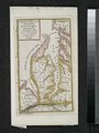 | 3,696 × 4,939 (52.23 MB) | Fæ (talk | contribs) | GWToolset:: Creating mediafile for Fæ. Tranche 2.590 |
You cannot overwrite this file.
File usage on Commons
There are no pages that use this file.