File:A Generall chart for the West Indies - according to Mr. Edw. Wrights projection commonly called Mercators chart - Js. Barlow ft. NYPL434471.tiff
Jump to navigation
Jump to search

Size of this JPG preview of this TIF file: 717 × 599 pixels. Other resolutions: 287 × 240 pixels | 574 × 480 pixels | 919 × 768 pixels | 1,225 × 1,024 pixels | 2,450 × 2,048 pixels | 5,531 × 4,624 pixels.
Original file (5,531 × 4,624 pixels, file size: 73.21 MB, MIME type: image/tiff)
Captions
Captions
Add a one-line explanation of what this file represents
Summary[edit]
| Description | A Generall chart for the West Indies : according to Mr. Edw. Wrights projection commonly called Mercators chart / Js. Barlow ft.; Lawrence H. Slaughter Collection of English maps, charts, globes, books and atlases / Charts and maps | |||||||||||||||||||||||
| Notes | Covers Atlantic Ocean between N 550 and S 140. ''Note 2.'') Depths shown by soundings. ''Note 3.'') Lawrence H. Slaughter Collection ; 422. ''Note 4.'') National Endowment for the Humanities Grant for Access to Early Maps of the Middle Atlantic Seaboard. | |||||||||||||||||||||||
| Catalogue call number | Map Div. 97-6337 [LHS 422] | |||||||||||||||||||||||
| Date | circa 1702 | |||||||||||||||||||||||
| Source |
http://digitalgallery.nypl.org/nypldigital/dgkeysearchdetail.cfm?imageID=434471
|
|||||||||||||||||||||||
| Author | Rich. Mount and Tho. Page -- Publisher ;Barlow, James, 18th cent. -- Artist | |||||||||||||||||||||||
| Permission (Reusing this file) |
From The Lionel Pincus and Princess Firyal Map Division. http://maps.nypl.org
|
|||||||||||||||||||||||
| Location | Stephen A. Schwarzman Building / The Lionel Pincus and Princess Firyal Map Division | |||||||||||||||||||||||
| Digital item published | 2-3-2004; updated 3-25-2011 | |||||||||||||||||||||||
| Digital ID | 434471 | |||||||||||||||||||||||

The making of this file was supported by Wikimedia UK.
To see other files made with the support of Wikimedia UK, please see the category Supported by Wikimedia UK.
|
File history
Click on a date/time to view the file as it appeared at that time.
| Date/Time | Thumbnail | Dimensions | User | Comment | |
|---|---|---|---|---|---|
| current | 12:09, 16 August 2016 |  | 5,531 × 4,624 (73.21 MB) | SteinsplitterBot (talk | contribs) | Bot: Image rotated by 270° |
| 08:41, 20 April 2014 | 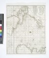 | 4,624 × 5,531 (73.18 MB) | Fæ (talk | contribs) | GWToolset:: Creating mediafile for Fæ. Tranche 2.389 |
You cannot overwrite this file.
File usage on Commons
There are no pages that use this file.