File:A Chart of the Atlantic or Western Ocean - Jones, sc. NYPL433947.tiff
Jump to navigation
Jump to search

Size of this JPG preview of this TIF file: 800 × 596 pixels. Other resolutions: 320 × 238 pixels | 640 × 477 pixels | 1,024 × 763 pixels | 1,280 × 954 pixels | 2,560 × 1,907 pixels | 5,648 × 4,208 pixels.
Original file (5,648 × 4,208 pixels, file size: 68 MB, MIME type: image/tiff)
Captions
Captions
Add a one-line explanation of what this file represents
Summary[edit]
| Description | [A Chart of the Atlantic or Western Ocean] / Jones, sc.; Lawrence H. Slaughter Collection of English maps, charts, globes, books and atlases / Charts and maps | |||||||||||||||||||||||
| Notes | "Plate IV." ''Note 2.'') Bancroft Collection. ''Note 3.'') Lawrence H. Slaughter Collection ; 448. ''Note 4.'') National Endowment for the Humanities Grant for Access to Early Maps of the Middle Atlantic Seaboard. ''Note 5.'') Prime meridians: London and Ferro. ''Note 6.'') Shows route of the Gulf Stream, ship courses, and temperature readings. ''Note 7.'') Title supplied by the cataloger based on prominent labelling on map. ''Note 8.'') To accompany William Strickland's article in the Transactions of the American Philosophical Society. Vol. 5, 1802. | |||||||||||||||||||||||
| Catalogue call number | Map Div. 01-10258 [Filed with Atlantic Ocean, 1798, as originally cataloged in NYPL Dictionary Catalog of the Map Division] | |||||||||||||||||||||||
| Standard reference | NYPL. Dictionary catalog of the Map Division, I, p. 475 | |||||||||||||||||||||||
| Date | ||||||||||||||||||||||||
| Source |
http://digitalgallery.nypl.org/nypldigital/dgkeysearchdetail.cfm?imageID=433947
|
|||||||||||||||||||||||
| Author | Budd and Bartram -- Printer ;Strickland, William, 1787-1854 -- Author ;Dobson, Thomas, 1751-1823 -- Publisher; Jones, Ira -- Engraver | |||||||||||||||||||||||
| Permission (Reusing this file) |
From The Lionel Pincus & Princess Firyal Map Division. http://maps.nypl.org
|
|||||||||||||||||||||||
| Location | Stephen A. Schwarzman Building / The Lionel Pincus and Princess Firyal Map Division | |||||||||||||||||||||||
| Digital item published | 2-3-2004; updated 3-25-2011 | |||||||||||||||||||||||
| Digital ID | 433947 | |||||||||||||||||||||||

The making of this file was supported by Wikimedia UK.
To see other files made with the support of Wikimedia UK, please see the category Supported by Wikimedia UK.
|
File history
Click on a date/time to view the file as it appeared at that time.
| Date/Time | Thumbnail | Dimensions | User | Comment | |
|---|---|---|---|---|---|
| current | 07:54, 22 July 2022 |  | 5,648 × 4,208 (68 MB) | Sebastian Wallroth (talk | contribs) | Cropped -34 % horizontally, 26 % vertically, rotated 270° using CropTool with lossless mode. |
| 07:35, 20 April 2014 | 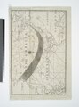 | 4,208 × 5,651 (68.04 MB) | Fæ (talk | contribs) | GWToolset:: Creating mediafile for Fæ. Tranche 2.229 |
You cannot overwrite this file.
File usage on Commons
The following page uses this file: