Category:United States Geological Survey maps
Jump to navigation
Jump to search
English: Maps made by the United States Geological Survey. You can identify the license with {{PD-USGov-USGS}}
Subcategories
This category has the following 14 subcategories, out of 14 total.
C
H
M
- Map of United States, 1890 (11 F)
N
S
U
- USGS isoseismal maps (36 F)
- USGS maps of Guam (22 F)
- USGS maps of Peru (1 F)
Media in category "United States Geological Survey maps"
The following 200 files are in this category, out of 607 total.
(previous page) (next page)-
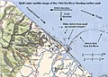 "Quill" satellite radar image of flooded Eel River outflow current.JPG 1,000 × 719; 123 KB
-
 12 elect14.png 3,183 × 2,437; 1.43 MB
-

-
 1853 U.S.C.S. Map of St. John's River, Florida - Geographicus - StJohnRiver-uscs-1853.jpg 3,082 × 4,000; 1.54 MB
-

-

-
-
-
-

-

-

-

-

-

-
-
-

-
 1902 USGS topo map of Baring, Washington.jpg 3,000 × 3,000; 3.94 MB
-

-

-

-

-
 1909 Wabash valley earthquake map.png 250 × 299; 56 KB
-
 1913 U.S.G.S. New York ^ New Jersey Atlas - Geographicus - NYAtlas-usgs-1815.jpg 1,860 × 2,082; 508 KB
-
 1915 pleasant valley earthquake map.png 331 × 466; 114 KB
-
 1916 Irondale epicenter map.png 331 × 426; 96 KB
-
-
 1928 USGSexcerptOLGA.jpg 2,295 × 1,167; 686 KB
-
-

-

-

-
 1971 Geologic Map of the Near Side of the Moon Cropped.png 4,095 × 4,590; 26.48 MB
-
 1990 Luzon intensity.jpg 612 × 717; 91 KB
-
 1990 Panay earthquake intensity map.jpg 787 × 996; 282 KB
-
 1997 northern iran earthquake map (Persian).jpg 504 × 468; 144 KB
-
 1997 northern iran earthquake map.jpg 504 × 568; 85 KB
-
 2004 hurricanes.jpg 302 × 336; 46 KB
-
 2007 alum rock earthquake map.jpg 498 × 584; 60 KB
-
 2008 Sichuan Earthquake aftershockes through May 28.pdf 1,275 × 1,650; 1.29 MB
-
 2012 M7-3 Kamaishi Japan Map.png 540 × 558; 83 KB
-
 2015 Kivu Earthquake Intensity Map.jpg 612 × 684; 282 KB
-
 7.5 minute series orthophotomap (topographic).jpg 3,783 × 4,500; 3.38 MB
-
 Aiken Illinois 1911 USGS Map Excerpt.png 852 × 823; 1.8 MB
-
 Alt USGS-Map.jpg 677 × 507; 178 KB
-
 AngolaBigTopo (cropped).PNG 1,024 × 1,280; 1.78 MB
-
 AngolaBigTopo.PNG 2,772 × 2,238; 10.43 MB
-
 Arizona and New Mexico Territories Map, 1896.jpg 2,438 × 1,901; 2.17 MB
-
 Arizona Territory Map, 1884.jpg 2,789 × 3,956; 4.54 MB
-
 Arizona Territory Map, 1889.jpg 2,753 × 4,038; 4.48 MB
-
 Arizona Territory Map, 1898, 2.jpg 1,968 × 2,460; 2.42 MB
-
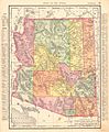 Arizona Territory Map, 1898.jpg 2,205 × 2,677; 2.64 MB
-
 Arkansas State Map, 1914.jpg 5,696 × 4,737; 12.28 MB
-
 Baker and West Baker USGS 1947.png 1,357 × 654; 1.1 MB
-
 Basins and arches of the Atlantic Coastal Plain.png 404 × 549; 70 KB
-
 Baton Rouge Port Allen Map Louisiana 1963.jpg 3,740 × 4,500; 4.56 MB
-
 CA Chico 20180912 TM geo (image layer).jpg 1,728 × 2,088; 1.6 MB
-
 CA Chico 299063 1980 100000 geo.pdf 5,993 × 3,610; 33.14 MB
-

-
 CampBMap.PNG 1,613 × 1,876; 3.1 MB
-
 CapeSableTopo.jpg 600 × 400; 88 KB
-
 Capital Region International Airport Topo USGS 01-Jul-80.jpg 650 × 450; 175 KB
-
 Cash Hollow Excerpt - VA Massies Mill 185829 1965 24000 geo.jpg 2,199 × 1,705; 1.12 MB
-
 Childwold New York USGS topo map 1920.jpg 2,957 × 3,612; 3.73 MB
-
 ClemensUnitTopog.PNG 555 × 568; 489 KB
-
 Cleveland map 1904.jpg 1,576 × 1,154; 843 KB
-
 CoffieldUnitTopographical.PNG 891 × 638; 1.04 MB
-
 Continuous map of the United States, 1975.jpg 4,200 × 2,727; 1.86 MB
-
 Cooper Lake 1954.png 1,160 × 845; 1.75 MB
-
 Corbin Iconium MO Quadrangle 1940 excerpt.jpg 1,011 × 1,019; 637 KB
-
 Corbin Iconium quad 1991 excerpt.png 734 × 673; 1.45 MB
-
 CumminsUnitMap.tiff 765 × 751; 1.39 MB
-
 USGS Reconnaissance Map of Dallas County, Texas 1893 (1909) UTA.jpg 6,846 × 8,300; 16.44 MB
-
 Dannemora New York USGS topo map 1911.jpg 2,587 × 3,619; 3.1 MB
-
 DarringtonUnitTopographical.PNG 764 × 384; 426 KB
-
 Davis Airport Michigan Topo USGS 01-Jul-80.jpg 640 × 480; 62 KB
-
 Distribution of loess in North America.gif 412 × 444; 44 KB
-
 EAA2 Mississippi River Delta.pdf 3,900 × 4,200; 14.96 MB
-
 Earthquake map.jpeg 2,250 × 1,500; 958 KB
-
 East Fork Russian River USGS topo map.png 516 × 694; 448 KB
-
 East vs West Coast Earthquakes USGS.jpg 3,600 × 3,000; 1.75 MB
-
 EasthamFergusonUnits.PNG 990 × 668; 1.02 MB
-
 Eathquake swarm.gif 543 × 532; 15 KB
-
 Elizabethtown New York USGS topo map 1892.jpg 3,043 × 3,597; 4.36 MB
-
 EllisEstelleUnits.PNG 640 × 682; 889 KB
-
 Embarcadero Freeway map.png 936 × 1,202; 571 KB
-
 Europa USGS map.jpg 5,702 × 6,322; 5.39 MB
-
 Feather Falls, Butte County.jpg 200 × 200; 19 KB
-
 Fort Ann New York USGS topo map 1893.jpg 3,079 × 3,612; 3.72 MB
-
 Fort Collins Colorado Temple map.JPG 939 × 704; 135 KB
-
 Fort Lauderdale Florida Temple.JPG 786 × 590; 91 KB
-
 FPCAldersonTopographical.PNG 657 × 230; 372 KB
-
 French Frigate Shoals map.png 569 × 289; 9 KB
-
 Ga coast.jpg 816 × 1,056; 105 KB
-
 Ganymede-JupiterMoon-GeologicMap-SIM3237-20140211.png 5,801 × 4,099; 17.43 MB
-
 GatesvillePrisonsTX1994.PNG 1,019 × 755; 1.19 MB
-
 GatesvilleStateSchoolTopographical.PNG 420 × 445; 389 KB
-
 Geologic Map of Mars figure2.pdf 1,725 × 1,752; 370 KB
-
 Geologic Map of Mars.pdf 8,383 × 6,404; 34.46 MB
-
 Geologic map of Sanders quadrangle northern Arizona.jpg 6,042 × 11,567; 6.35 MB
-
 Geologic Map of the Near Side of the Moon.jpg 8,016 × 5,341; 37.7 MB
-
 Glens Falls New York USGS topo map 1895.jpg 3,059 × 3,889; 3.7 MB
-
 GoreeUnitNewTopo.PNG 839 × 412; 746 KB
-
 GoreeUnitTopog.PNG 528 × 308; 341 KB
-
 Green Valley Lake - Green Valley State Park - UGS Creston West Quad 1981.jpg 1,433 × 1,845; 1,002 KB
-
 Gregory 1916 USGS Water Supply Paper 380 plate-1.jpg 12,400 × 10,109; 8.37 MB
-
 Gregory 1916 USGS Water Supply Paper 380 plate-2.jpg 12,200 × 9,600; 11.89 MB
-
 Gregory 1938 USGS Professional Paper 188 Plate 1.jpg 2,431 × 1,763; 1.22 MB
-
 Guadalupe Island Map.gif 507 × 724; 43 KB
-
 GWU USGS raw3.gif 1,230 × 784; 518 KB
-
 Harrison New York Temple map.JPG 959 × 718; 179 KB
-
 Hartford Connecticut Temple.jpg 1,341 × 775; 346 KB
-
 Hawaii 1998 0p2s 2p50.png 730 × 570; 51 KB
-
 Hicks Airfield Map.jpg 506 × 392; 27 KB
-
 HUC 031300010101 - Headwaters Chattahoochee River.PNG 379 × 472; 417 KB
-
 HUC 031300010102 - Smith Creek-Chattahoochee River.PNG 336 × 571; 441 KB
-
 HUC 031300010102 topographic map.tiff 692 × 1,192; 1.99 MB
-
 HUC 031300010103 - Dukes Creek.PNG 517 × 421; 507 KB
-
 HUC 031300010103 topographic map.tiff 1,146 × 950; 2.56 MB
-
 HUC 031300010104 - Chickamauga Creek.PNG 473 × 528; 581 KB
-
 HUC 031300010104 topographic map.tiff 1,006 × 1,096; 2.45 MB
-
 HUC 031300010105 - Amys Creek-Chattahoochee River.PNG 385 × 364; 320 KB
-
 HUC 031300010105 topographic map.tiff 940 × 870; 1.65 MB
-
 HUC 031300010106 - Blue Creek-Chattahoochee River.PNG 464 × 491; 512 KB
-
 HUC 031300010106 topographical map.tiff 1,290 × 1,194; 3.15 MB
-
 HUC 031300010201 - Headwaters Soque River.PNG 505 × 447; 529 KB
-
 HUC 031300010201 topographical map.PNG 474 × 716; 686 KB
-
 HUC 031300010202 - Shoal Creek-Upper Soque River.PNG 432 × 452; 450 KB
-
 HUC 031300010202 topographical map.PNG 374 × 624; 407 KB
-
 HUC 031300010203 - Deep Creek.PNG 316 × 555; 403 KB
-
 HUC 031300010203 topographical map.PNG 453 × 616; 502 KB
-
 HUC 031300010204 - Beaverdam Creek-Middle Soque River.PNG 441 × 401; 395 KB
-
 HUC 031300010204 topographical map.PNG 542 × 562; 557 KB
-
 HUC 031300010205 - Hazel Creek.PNG 547 × 420; 521 KB
-
 HUC 031300010205 topographical map.PNG 801 × 627; 994 KB
-
 HUC 031300010206 - Yellowbank Creek-Lower Soque River.PNG 258 × 450; 262 KB
-
 HUC 031300010206 topographical map.PNG 535 × 660; 691 KB
-
 HUC 031300010301 - White Creek-Chattahoochee River.tiff 872 × 928; 1.78 MB
-
 HUC 031300010301 topographic map.tiff 686 × 940; 1.32 MB
-
 HUC 031300010302 - Mossy Creek.tiff 890 × 962; 1.83 MB
-
 HUC 031300010302 topographic map.tiff 1,012 × 1,020; 2.13 MB
-
 HUC 031300010303 - Mud Creek.tiff 1,128 × 982; 2.47 MB
-
 HUC 031300010303 topographic map.tiff 1,318 × 1,088; 3.8 MB
-
 HUC 031300010304 - Flat Creek-Chattahoochee River.tiff 1,156 × 1,102; 2.79 MB
-
 HUC 031300010304 topographic map.tiff 1,622 × 1,252; 5.54 MB
-
 HUC 031300010305 - Limestone Creek-Chattahoochee River.tiff 1,176 × 1,032; 2.62 MB
-
 HUC 031300010305 topographic map.tiff 1,556 × 1,274; 5.9 MB
-
 HUC 031300010401 - Wahoo Creek.tiff 1,210 × 1,570; 4.06 MB
-
 HUC 031300010401 topographic map.tiff 1,370 × 1,438; 5.13 MB
-
 HUC 0313000105 to 07 - Chestatee River watersheds.tiff 670 × 1,000; 1.62 MB
-
 HUC 0313000105 to 07 topographic map - Chestatee River area.tiff 568 × 940; 675 KB
-
 HUC 031300010501 - Dicks Creek.tiff 1,042 × 752; 1.65 MB
-
 HUC 031300010501 topographic map.tiff 1,296 × 916; 3.12 MB
-
 HUC 031300010502 and 504 - Tesnatee Creek.tiff 1,040 × 1,296; 2.96 MB
-
 HUC 031300010502 and 504 topographic map.tiff 1,210 × 1,606; 4.29 MB
-
 HUC 031300010503 - Town Creek.tiff 620 × 1,180; 1.6 MB
-
 HUC 031300010503 topographic map.tiff 670 × 1,616; 2.55 MB
-
 HUC 031300010505 - Tate Creek-Chestatee River.tiff 806 × 932; 1.72 MB
-
 HUC 031300010505 topographic map.tiff 1,224 × 1,332; 3.82 MB
-
 HUC 031300010601 - Cavenders Creek-Chestatee River.tiff 854 × 822; 1.67 MB
-
 HUC 031300010601 topographic map.tiff 1,696 × 1,102; 4.27 MB
-
 HUC 031300010602 - Yahoola Creek.tiff 750 × 1,272; 2.25 MB
-
 HUC 031300010602 topographic map.tiff 790 × 1,434; 3.1 MB
-
 HUC 031300010603 - Cane Creek.tiff 654 × 1,222; 1.93 MB
-
 HUC 031300010604 - Long Branch-Chestatee River.tiff 918 × 594; 1.31 MB
-
 HUC 031300010604 topographic.tiff 800 × 1,170; 2.59 MB
-
 HUC 031300010701 - Yellow Creek-Chestatee River.tiff 950 × 706; 1.5 MB
-
 HUC 031300010701 topographic map.tiff 1,012 × 1,068; 3.25 MB
-
 HUC 031300010702 - Thompson Creek-Chestatee River.tiff 934 × 764; 1.49 MB
-
 HUC 031300010702 topographic map.tiff 1,064 × 1,064; 3.47 MB
-
 HUC 031300010703 - Latham Creek-Chestatee River.tiff 608 × 598; 758 KB
-
 HUC 031300010703 topographic map.tiff 1,002 × 912; 2.68 MB
-
 HUC 031300010704 - Taylor Creek-Chestatee River.tiff 786 × 490; 814 KB
-
 HUC 031300010704 topographic map.tiff 1,140 × 738; 2.55 MB
-
 HUC 031300010705 - Martin Creek-Chestatee River.tiff 736 × 560; 816 KB
-
 HUC 031300010705 - Martin Creek-Lake Sidney Lanier.PNG 909 × 595; 931 KB
-
 HUC 031300010705 topographic map.tiff 1,116 × 766; 2.66 MB
-
 HUC 0313000108 - Lake Lanier watersheds.tiff 1,040 × 938; 2.23 MB
-
 HUC 0313000108 topographic map - Lake Lanier area.tiff 1,818 × 1,386; 7.74 MB
-
 HUC 031300010801 - Upper Lake Sidney Lanier.tiff 1,152 × 1,118; 2.54 MB
-
 HUC 031300010802 - Flat Creek.tiff 1,016 × 728; 1.4 MB
-
 HUC 031300010802 topographic map.tiff 1,560 × 1,132; 5.43 MB
-
 HUC 180701 01.jpg 636 × 438; 202 KB
-
 HUC 180702.jpg 636 × 438; 213 KB
-
 HUC 180703.jpg 636 × 438; 184 KB
-
 Huc region-edit.png 500 × 320; 17 KB
-
 HUC Regions Map - NHDPlusHRStatus.png 4,200 × 3,400; 1.32 MB
-
 HUC subregions.png 7,200 × 5,400; 1 MB
-
 HUC01.jpg 632 × 434; 204 KB
-
 HUC0101.jpg 632 × 434; 308 KB
-
 HUC0102.jpg 632 × 434; 485 KB
-
 HUC0103.jpg 632 × 434; 464 KB
-
 HUC0104.jpg 636 × 438; 325 KB
-
 HUC0105.jpg 632 × 434; 508 KB
-
 HUC0106.jpg 632 × 434; 370 KB
-
 HUC0107.jpg 632 × 434; 421 KB
-
 HUC0108.jpg 632 × 434; 511 KB
-
 HUC0109.jpg 632 × 434; 434 KB
-
 HUC0110.jpg 636 × 438; 323 KB


_-_Geographicus_-_HornIslandPass-uscs-1853.jpg)


_-_Geographicus_-_YellowstoneGeo-usgs-1896.jpg)
_-_Geographicus_-_Yellowstone-usgs-1896.jpg)


_-_Geographicus_-_Montauk-uscs-1925.jpg)


_-_landmark_Lunar_map%5E_-_Geographicus_-_LunarRays-usgs-1961.jpg)
_-_landmark_Lunar_map%5E_-_Geographicus_-_PhotogeologicMoon-usgs-1961.jpg)
_-_landmark_Lunar_map%5E_-_Geographicus_-_MoonPhysical-usgs-1961.jpg)


.jpg)


.jpg)


.PNG)


.jpg)


_UTA.jpg)


