Category:1981 maps
Jump to navigation
Jump to search
| ← · 1980 · 1981 · 1982 · 1983 · 1984 · 1985 · 1986 · 1987 · 1988 · 1989 · → |
Deutsch: Karten mit Bezug zum Jahr 1981
English: Maps related to the year 1981
Español: Mapas relativos al año 1981
Français : Cartes concernant l’an 1981
Русский: Карты 1981 года
Subcategories
This category has the following 9 subcategories, out of 9 total.
Media in category "1981 maps"
The following 126 files are in this category, out of 126 total.
-
 (D.C. & vicinity to Beltway). LOC 89694449.jpg 15,153 × 10,685; 32.24 MB
-
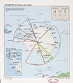 Antarctica, stations and claims. LOC 85697838.jpg 3,718 × 4,208; 1.34 MB
-
 Antarctica, stations and claims. LOC 85697838.tif 3,718 × 4,208; 44.76 MB
-
 Appalachian Trail LOC 83694254.jpg 8,868 × 13,397; 12.41 MB
-
 Appalachian Trail LOC 83694254.tif 8,868 × 13,397; 339.9 MB
-

-

-
 Atchafalaya outlet, Mississippi River and tributaries LOC 94680614.jpg 10,055 × 7,447; 11.72 MB
-
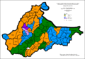 Brcko - Etnicki sastav po naseljima 1981.gif 3,700 × 2,592; 288 KB
-
 Buffalo River, national river, Arkansas LOC 85696001.jpg 10,036 × 4,742; 8.38 MB
-
 Buffalo River, national river, Arkansas LOC 85696001.tif 10,036 × 4,742; 136.16 MB
-
 Copiah Creek Watershed, Copiah County, Mississippi LOC 85693526.jpg 3,278 × 4,298; 1.39 MB
-
 Copiah Creek Watershed, Copiah County, Mississippi LOC 85693526.tif 3,278 × 4,298; 40.31 MB
-
 D.C. & immediate vicinity. LOC 89694446.jpg 12,799 × 20,441; 46.25 MB
-
 D.C. & vicinity to Beltway. LOC 89694445.jpg 17,830 × 12,823; 38.18 MB
-
 D.C. & vicinity to Beltway. LOC 89694445.tif 17,830 × 12,823; 654.13 MB
-
 Europe, North Africa, and Southwest Asia. LOC 00557739.jpg 5,978 × 4,271; 2.55 MB
-
 Europe, North Africa, and Southwest Asia. LOC 00557739.tif 5,978 × 4,271; 73.05 MB
-

-

-
 Francis Marion National Forest, South Carolina LOC 83690424.jpg 13,495 × 7,029; 14.97 MB
-
 Francis Marion National Forest, South Carolina LOC 83690424.tif 13,495 × 7,029; 271.39 MB
-
 General soil map, Atascosa County, Texas LOC 83695271.jpg 7,686 × 11,637; 7.85 MB
-
 General soil map, Atascosa County, Texas LOC 83695271.tif 7,686 × 11,637; 255.9 MB
-

-

-
 General soil map, Kerr County, Texas LOC 83693514.tif 7,748 × 11,516; 255.28 MB
-
 General soil map, Rockingham County, North Carolina LOC 81693474.jpg 6,057 × 6,688; 4.89 MB
-
 General soil map, Rockingham County, North Carolina LOC 81693474.tif 6,057 × 6,688; 115.9 MB
-
 Great Plains Conservation Program, designated counties LOC 84690377.jpg 6,256 × 7,649; 3.76 MB
-
 Great Plains Conservation Program, designated counties LOC 84690377.tif 6,256 × 7,649; 136.91 MB
-
 Great Smoky Mountains National Park, North Carolina-Tennessee, trail map LOC 81692179.jpg 7,048 × 5,002; 9.84 MB
-
 Great Smoky Mountains National Park, North Carolina-Tennessee, trail map LOC 81692179.tif 7,048 × 5,002; 100.86 MB
-
 Homochitto National Forest, Mississippi LOC 83693115.jpg 6,957 × 7,267; 8.11 MB
-
 Homochitto National Forest, Mississippi LOC 83693115.tif 6,957 × 7,267; 144.64 MB
-
 Hydrologic unit map-1981, Vermont LOC 90683492.tif 2,636 × 6,668; 50.29 MB
-

-

-
 Important farmlands, Lincoln County, Mississippi LOC 98681883.jpg 8,819 × 6,404; 6.72 MB
-
 Important farmlands, Lincoln County, Mississippi LOC 98681883.tif 8,819 × 6,404; 161.58 MB
-
 Istria-Croats-1981.gif 640 × 786; 84 KB
-
 Istria-Ethnic-1981.gif 640 × 786; 83 KB
-
 Istria-Serbs-1981.gif 640 × 786; 89 KB
-
 Istria-Slovenians-1981.gif 640 × 786; 89 KB
-
 Istria-Yugoslavs-1981.gif 640 × 786; 100 KB
-
 John H. Kerr Dam & Reservoir, Virginia and North Carolina LOC 82696228.jpg 9,667 × 7,267; 8.59 MB
-
 John H. Kerr Dam & Reservoir, Virginia and North Carolina LOC 82696228.tif 9,667 × 7,267; 200.99 MB
-
 Land use map, Juniata County, Pennsylvania LOC 82690602.jpg 5,286 × 3,419; 2.23 MB
-
 Land use map, Juniata County, Pennsylvania LOC 82690602.tif 5,286 × 3,419; 51.71 MB
-
 Leeward Islands - DPLA - bd1887ad87c11a342940d670a6264a8d.jpg 2,558 × 3,278; 5.19 MB
-
-

-
 Major land resource areas with excessive water erosion, Texas LOC 82692895.jpg 2,537 × 3,287; 803 KB
-
 Major land resource areas with excessive water erosion, Texas LOC 82692895.tif 2,537 × 3,287; 23.86 MB
-
 Major Soviet Roads, 1981.png 1,362 × 898; 180 KB
-
 Map of Eurovision 1981.gif 1,236 × 1,245; 35 KB
-

-

-
 Mercer Co., N.J. - N4007.5-W7428.5-18.5 x 29 - 1981 LOC 85695372.jpg 5,268 × 5,002; 3.07 MB
-
 Mercer Co., N.J. - N4007.5-W7428.5-18.5 x 29 - 1981 LOC 85695372.tif 5,268 × 5,002; 75.39 MB
-
-

-
 Mount Vernon Trail, George Washington Memorial Parkway LOC 83693766.jpg 6,872 × 6,377; 7.13 MB
-
 Mount Vernon Trail, George Washington Memorial Parkway LOC 83693766.tif 6,872 × 6,377; 125.38 MB
-
 Nantahala National Forest, North Carolina LOC 82696339.jpg 14,212 × 6,401; 17.76 MB
-
 Nantahala National Forest, North Carolina LOC 82696339.tif 14,212 × 6,401; 260.27 MB
-
 National capital region - Washington D.C.. LOC 89694447.jpg 14,352 × 12,282; 22.06 MB
-
 National capital region - Washington D.C.. LOC 89694447.tif 14,352 × 12,282; 504.32 MB
-
 New Hampshire organizational map LOC 81692938.jpg 2,542 × 3,296; 983 KB
-
 New Hampshire organizational map LOC 81692938.tif 2,542 × 3,296; 23.97 MB
-
 Okatibbee Lake LOC 85693573.jpg 14,514 × 5,467; 11.12 MB
-
 Okatibbee Lake LOC 85693573.tif 14,514 × 5,467; 227.02 MB
-
 Paris - Dakar route (1981) ru.svg 999 × 999; 534 KB
-
 Population changes, 1970-1980, Texas LOC 82692891.jpg 2,534 × 3,248; 801 KB
-
 Population changes, 1970-1980, Texas LOC 82692891.tif 2,534 × 3,248; 23.55 MB
-

-

-

-
 Project map, Cartwheel community watershed, Horry County, South Carolina LOC 83692802.jpg 3,843 × 3,257; 1.68 MB
-
 Project map, Cartwheel community watershed, Horry County, South Carolina LOC 83692802.tif 3,843 × 3,257; 35.81 MB
-

-

-

-

-

-

-

-
 Project map, West Franklin Watershed, Franklin and Richland parishes, Louisiana LOC 85693524.tif 3,183 × 5,757; 52.43 MB
-

-

-
 Richmond National Battlefield Park, Virginia LOC 93681951.jpg 13,382 × 6,355; 13.22 MB
-
 Richmond National Battlefield Park, Virginia LOC 93681951.tif 13,382 × 6,355; 243.31 MB
-
 Rock Creek Park LOC 82693405.jpg 5,252 × 7,225; 5.67 MB
-
 Rock Creek Park LOC 82693405.tif 5,252 × 7,225; 108.56 MB
-
 Sarajevo - Etnicki sastav po naseljima 1981.gif 2,806 × 3,252; 238 KB
-
 Shenandoah National Park LOC 81693445.jpg 11,246 × 6,664; 8.76 MB
-
 Shenandoah National Park LOC 81693445.tif 11,246 × 6,664; 214.41 MB
-
 South Carolina, 1-50,000. Fort Jackson military installation map LOC 99444895.jpg 8,789 × 6,838; 9.98 MB
-
 South Carolina, 1-50,000. Fort Jackson military installation map LOC 99444895.tif 8,789 × 6,838; 171.95 MB
-
 South Central New York Resource Conservation and Development Project LOC 81693318.jpg 4,744 × 3,277; 2.05 MB
-
 South Central New York Resource Conservation and Development Project LOC 81693318.tif 4,744 × 3,277; 44.48 MB
-
 South Toe River trail map, Pisgah National Forest, North Carolina LOC 2009575457.jpg 14,810 × 9,657; 19.46 MB
-
 Soviet global power projection, 1981.jpg 2,690 × 1,434; 567 KB
-
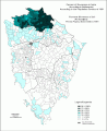
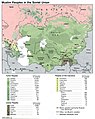 Soviet muslim peoples.jpg 1,015 × 1,276; 257 KB
-

-

-

-
 Spruce Knob-Seneca Rocks National Recreation Area, Monongahela National Forest LOC 82696336.tif 10,459 × 6,083; 182.02 MB
-
 Standard metropolitan statistical areas of Texas LOC 85692452.jpg 2,524 × 3,285; 740 KB
-
 Standard metropolitan statistical areas of Texas LOC 85692452.tif 2,524 × 3,285; 23.72 MB
-
 Status of detailed soil surveys, Vermont. LOC 82690887.tif 2,508 × 3,262; 23.41 MB
-

-

-
 The Harbor of Annapolis - founded upon a trigonometrical survey LOC 83692797.jpg 4,608 × 3,600; 2.74 MB
-
 The Harbor of Annapolis - founded upon a trigonometrical survey LOC 83692797.tif 4,608 × 3,600; 47.46 MB
-
 Route of the 1981 Tour de France.png 3,198 × 3,204; 2.72 MB
-
 Uwharrie National Forest, North Carolina LOC 83694431.jpg 12,173 × 6,397; 11.84 MB
-
 Uwharrie National Forest, North Carolina LOC 83694431.tif 12,173 × 6,397; 222.79 MB
-

-

-

-

-
 Yugoslavia. LOC 2011587053.jpg 3,323 × 4,342; 1.61 MB
-
 Yugoslavia. LOC 2011587053.tif 3,323 × 4,342; 41.28 MB
-
 Yugoslavia. LOC 2011587054.jpg 3,322 × 4,317; 1.92 MB
-
 Yugoslavia. LOC 2011587054.tif 3,322 × 4,317; 41.03 MB
._LOC_89694449.jpg)


_ru.svg)

_Watershed_of_the_Brazos_River_Watershed,_portions_of_TX-SWCD-31_and_24_in_Falls,_Limestone_and_McLennan_Counties,_Texas_LOC_85693528.jpg)


,_Kentucky,_1981_LOC_85693983.jpg)


._LOC_2013589539.jpg)


