Category:1990 maps
Jump to navigation
Jump to search
| ← · 1990 · 1991 · 1992 · 1993 · 1994 · 1995 · 1996 · 1997 · 1998 · 1999 · → |
Deutsch: Karten mit Bezug zum Jahr 1990
English: Maps related to the year 1990
Español: Mapas relativos al año 1990
Français : Cartes concernant l’an 1990
Русский: Карты 1990 года
Subcategories
This category has the following 10 subcategories, out of 10 total.
Media in category "1990 maps"
The following 172 files are in this category, out of 172 total.
-
 Antietam National Battlefield LOC 90683373.jpg 10,651 × 8,511; 9.48 MB
-
 Antietam National Battlefield LOC 90683373.tif 10,651 × 8,511; 259.35 MB
-
 Aomen, Zhuhai = Map of Macau & Zhuhai - with English introduction. LOC 92682800.jpg 14,568 × 10,860; 15.84 MB
-
 Area 5, Kentucky LOC 92682554.jpg 4,536 × 3,275; 1.09 MB
-
 Area 5, Kentucky LOC 92682554.tif 4,536 × 3,275; 42.5 MB
-
-

-
 Azimuthal equidistant projection centered on Tokyo, Japan, 35⁰42ʹN 139⁰46ʹE. LOC 90682803.jpg 11,253 × 12,207; 10.58 MB
-
 Azimuthal equidistant projection centered on Tokyo, Japan, 35⁰42ʹN 139⁰46ʹE. LOC 90682803.tif 11,253 × 12,207; 393.01 MB
-
 Bienvenue à Washington. LOC 91683049.jpg 6,896 × 8,574; 9.49 MB
-
 Bienvenue à Washington. LOC 91683049.tif 6,896 × 8,574; 169.16 MB
-
 Big Cypress National Preserve, Florida LOC 91685089.jpg 10,049 × 4,750; 10.33 MB
-
 Big Cypress National Preserve, Florida LOC 91685089.tif 10,049 × 4,750; 136.56 MB
-
 Big South Fork National River and Recreation Area, Kentucky-Tennessee LOC 90684421.jpg 9,986 × 7,028; 10.65 MB
-
 Big South Fork National River and Recreation Area, Kentucky-Tennessee LOC 90684421.tif 9,986 × 7,028; 200.79 MB
-
 Biscayne National Park, Florida LOC 91685085.jpg 10,030 × 7,055; 12.19 MB
-
 Biscayne National Park, Florida LOC 91685085.tif 10,030 × 7,055; 202.45 MB
-
 Blue Marsh Lake LOC 93685445.jpg 7,188 × 5,421; 5.27 MB
-
 Blue Marsh Lake LOC 93685445.tif 7,188 × 5,421; 111.48 MB
-
 Blue Ridge Parkway, North Carolina-Virginia LOC 2014588419.jpg 5,283 × 14,140; 11.9 MB
-
 Blue Ridge Parkway, North Carolina-Virginia LOC 2014588419.tif 5,283 × 14,140; 213.72 MB
-
 Buffalo National River - official map and guide LOC 90684109.jpg 10,039 × 4,749; 7.65 MB
-
 Buffalo National River - official map and guide LOC 90684109.tif 10,039 × 4,749; 136.4 MB
-

-

-
 Canton Lake LOC 91682401.jpg 7,389 × 10,486; 13.1 MB
-
 Canton Lake LOC 91682401.tif 7,389 × 10,486; 221.68 MB
-
 Cape Cod National Seashore, Massachusetts LOC 90685110.jpg 5,070 × 7,109; 5.34 MB
-
 Cuyahoga Valley National Recreation Area, Ohio - park and area map LOC 95681528.jpg 10,276 × 7,206; 10.7 MB
-
 Cuyahoga Valley National Recreation Area, Ohio - park and area map LOC 95681528.tif 10,276 × 7,206; 211.86 MB
-

-

-

-

-
 Directional commuting, census tract-level approach, Washington-Baltimore and vicinity LOC 99447945.jpg 10,245 × 13,096; 12.13 MB
-
 Directional commuting, census tract-level approach, Washington-Baltimore and vicinity LOC 99447945.tif 10,245 × 13,096; 383.86 MB
-
 Dominica. LOC 2005631606.jpg 2,486 × 3,269; 657 KB
-
 Dominica. LOC 2005631606.tif 2,486 × 3,269; 23.25 MB
-
 Earth-grazing meteoroid of 13 October 1990 locations map cs.svg 1,148 × 1,244; 490 KB
-
 Earth-grazing meteoroid of 13 October 1990 locations map sk.svg 1,148 × 1,244; 490 KB
-
 Francis Marion National Forest, South Carolina LOC 97683428.jpg 16,022 × 7,124; 17.31 MB
-
 Francis Marion National Forest, South Carolina LOC 97683428.tif 16,022 × 7,124; 326.56 MB
-
 General soil map of North Carolina LOC 2007629229.jpg 10,344 × 10,444; 11.16 MB
-
 General soil map of North Carolina LOC 2007629229.tif 10,344 × 10,444; 309.08 MB
-

-

-

-

-
 Great Falls Park, Virginia LOC 95682639.jpg 6,844 × 6,360; 9.97 MB
-
 Great Falls Park, Virginia LOC 95682639.tif 6,844 × 6,360; 124.53 MB
-
 Great Smoky Mountains National Park, North Carolina-Tennessee, trail map LOC 93681893.jpg 7,096 × 4,986; 10.66 MB
-
 Great Smoky Mountains National Park, North Carolina-Tennessee, trail map LOC 93681893.tif 7,096 × 4,986; 101.23 MB
-
 Green Mountain National Forest, Vermont - 1990 LOC 2006628246.jpg 2,551 × 6,653; 2.49 MB
-
 Green Mountain National Forest, Vermont - 1990 LOC 2006628246.tif 2,551 × 6,653; 48.56 MB
-
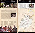 Greenbelt, Greenbelt Park, Maryland, official map and guide LOC 91684040.jpg 5,074 × 4,692; 3.14 MB
-
 Greenbelt, Greenbelt Park, Maryland, official map and guide LOC 91684040.tif 5,074 × 4,692; 68.11 MB
-
 Guadalupe Mountains - official map and guide LOC 91682378.tif 5,168 × 9,483; 140.21 MB
-
 Guilford County W-S protection study - drainage areas of wq strs. LOC 2007629479.jpg 5,143 × 3,334; 2.11 MB
-
 Guilford County W-S protection study - drainage areas of wq strs. LOC 2007629479.tif 5,143 × 3,334; 49.06 MB
-
 Guilford County W-S protection study - land use map LOC 2007629477.jpg 5,130 × 3,341; 2.61 MB
-
 Guilford County W-S protection study - land use map LOC 2007629477.tif 5,130 × 3,341; 49.04 MB
-
 Guilford County W-S protection study - map of hydrologic soil groups LOC 2005630257.jpg 5,157 × 3,349; 2.79 MB
-
 Guilford County W-S protection study - map of hydrologic soil groups LOC 2005630257.tif 5,157 × 3,349; 49.41 MB
-
 Guilford County W-S protection study - map of structures and hydric soils LOC 2007627686.jpg 5,141 × 3,348; 2.11 MB
-
 Guilford County W-S protection study - map of structures and hydric soils LOC 2007627686.tif 5,141 × 3,348; 49.24 MB
-
 Guilford County W-S protection study - planned water quality structures LOC 2007629480.jpg 5,138 × 3,349; 2.03 MB
-
 Guilford County W-S protection study - planned water quality structures LOC 2007629480.tif 5,138 × 3,349; 49.23 MB
-
 Guilford County W-S protection study - zoning map LOC 2007629478.jpg 5,160 × 3,354; 2.43 MB
-
 Guilford County W-S protection study - zoning map LOC 2007629478.tif 5,160 × 3,354; 49.51 MB
-
 Hartwell Lake recreation LOC 2006629749.tif 9,908 × 5,532; 156.82 MB
-
 High Plains Underground Water Conservation District No. 1, Texas LOC 92682545.jpg 3,276 × 4,170; 1.39 MB
-
 High Plains Underground Water Conservation District No. 1, Texas LOC 92682545.tif 3,276 × 4,170; 39.08 MB
-
 High Plains Underground Water Conservation District No. 1, Texas LOC 92682546.jpg 5,518 × 7,006; 4.08 MB
-
 High Plains Underground Water Conservation District No. 1, Texas LOC 92682546.tif 5,518 × 7,006; 110.6 MB
-
 Hotel-de-Blossac---1990.svg 311 × 320; 235 KB
-
 Hugo Lake LOC 90684334.jpg 5,103 × 7,173; 3.97 MB
-
 Hugo Lake LOC 90684334.tif 5,103 × 7,173; 104.72 MB
-
 J. Percy Priest Lake. LOC 91682396.jpg 14,452 × 5,454; 13.29 MB
-
 J. Percy Priest Lake. LOC 91682396.tif 14,452 × 5,454; 225.51 MB
-
 Kashmir region. LOC 91682088.jpg 3,764 × 3,789; 3.51 MB
-
 Kashmir region. LOC 91682088.tif 3,764 × 3,789; 40.8 MB
-
 Kaʾngei Washinton-shi. LOC 91682094.jpg 6,871 × 8,552; 8.24 MB
-
 Kaʾngei Washinton-shi. LOC 91682094.tif 6,871 × 8,552; 168.12 MB
-
 Lake Meredith and Alibates Flint Quarries LOC 91684628.jpg 5,208 × 9,606; 7.5 MB
-
 Lake Meredith and Alibates Flint Quarries LOC 91684628.tif 5,208 × 9,606; 143.13 MB
-
 Las Américas, mapa físico (1990).jpg 3,682 × 5,805; 3.51 MB
-
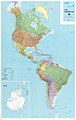 Las Américas, mapa político (1990).jpg 7,358 × 11,619; 12.06 MB
-
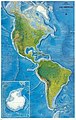
 Latin America, 1990.jpg 2,175 × 2,630; 5.79 MB
-
 Lewis and Clark in the Rocky Mountains LOC 91682738.tif 5,384 × 7,159; 110.28 MB
-
 Lower Mississippi Delta Development Commission targeted counties LOC 92682558.jpg 3,283 × 4,338; 1.58 MB
-
 Lower Mississippi Delta Development Commission targeted counties LOC 92682558.tif 3,283 × 4,338; 40.75 MB
-
 Macau, escala 1-5000 = (Ao-men, pi li) 1-5000. LOC 92684644.jpg 10,555 × 11,442; 12.69 MB
-
 Macau, escala 1-5000 = (Ao-men, pi li) 1-5000. LOC 92684644.tif 10,555 × 11,442; 345.53 MB
-
 Mammoth Cave National Park, Kentucky LOC 91682394.jpg 7,108 × 5,014; 6.67 MB
-
 Mammoth Cave National Park, Kentucky LOC 91682394.tif 7,108 × 5,014; 101.97 MB
-
 Martin Luther King, Jr., National Historic Site, Georgia LOC 91685009.jpg 10,067 × 4,741; 8.16 MB
-
 Mauritius. LOC 91680501.jpg 2,548 × 3,198; 965 KB
-
 Mauritius. LOC 91680501.tif 2,548 × 3,198; 23.31 MB
-
 Mauritius. LOC 91680502.jpg 2,371 × 3,150; 896 KB
-
 Mauritius. LOC 91680502.tif 2,371 × 3,150; 21.37 MB
-
 Middle East. LOC 2005631748.jpg 3,133 × 3,253; 861 KB
-
 Middle East. LOC 2005631748.tif 3,133 × 3,253; 29.16 MB
-
 Middle East. LOC 2011585055.jpg 4,304 × 3,318; 1.57 MB
-
 Middle East. LOC 2011585055.tif 4,304 × 3,318; 40.86 MB
-
 Middle East. LOC 91682079.jpg 12,827 × 10,092; 11.12 MB
-
 Middle East. LOC 91682079.tif 12,827 × 10,092; 370.36 MB
-
 NAVCOMMSTAPHIL.png 900 × 607; 387 KB
-
 Northern Africa and the Middle East. LOC 95682895.jpg 4,371 × 3,368; 1.3 MB
-
 Northern Africa and the Middle East. LOC 95682895.tif 4,371 × 3,368; 42.12 MB
-
 Northwest Indian Ocean area. LOC 2009583538.jpg 2,553 × 3,316; 750 KB
-
 Northwest Indian Ocean area. LOC 2009583538.tif 2,553 × 3,316; 24.22 MB
-
 Ohio 90.jpg 934 × 1,086; 440 KB
-
 Petersburg National Battlefield, Virginia LOC 95682631.jpg 13,482 × 6,404; 15.86 MB
-
 Petersburg National Battlefield, Virginia LOC 95682631.tif 13,482 × 6,404; 247.02 MB
-
 Philpott Lake, Virginia LOC 2013587302.jpg 12,952 × 7,317; 9.51 MB
-
 Philpott Lake, Virginia LOC 2013587302.tif 12,952 × 7,317; 271.14 MB
-

-

-
 Polish and Lithuanian boundaries, 1937 and present. LOC 2005626523.jpg 2,447 × 3,157; 491 KB
-
 Polish and Lithuanian boundaries, 1937 and present. LOC 2005626523.tif 2,447 × 3,157; 22.1 MB
-

-

-
-
 Race and Hispanic origin population density of the United States- 1990 LOC 97682420.tif 6,526 × 5,718; 106.76 MB
-
 Richland Creek Wilderness, Ozark National Forest, Arkansas, 1990. LOC 91684781.jpg 14,497 × 7,136; 15.11 MB
-
 Richland Creek Wilderness, Ozark National Forest, Arkansas, 1990. LOC 91684781.tif 14,497 × 7,136; 295.97 MB
-
 Rock Creek Park, Washington, D.C. - 100 years, 1890-1990 LOC 90684630.jpg 5,264 × 7,153; 5.92 MB
-
 Rock Creek Park, Washington, D.C. - 100 years, 1890-1990 LOC 90684630.tif 5,264 × 7,153; 107.73 MB
-

-
 San Antonio missions - official map and guide LOC 91682095.jpg 5,239 × 9,544; 6.8 MB
-
 San Antonio missions - official map and guide LOC 91682095.tif 5,239 × 9,544; 143.05 MB
-
 Snowbird area trail map - Nantahala National Forest, North Carolina LOC 2007627677.jpg 7,841 × 13,317; 19.82 MB
-
 Snowbird area trail map - Nantahala National Forest, North Carolina LOC 2007627677.tif 7,841 × 13,317; 298.74 MB
-
 Southeast Asia - strategic straits and maritime claims. LOC 2005632272.jpg 4,750 × 4,364; 3.16 MB
-
 Southeast Asia - strategic straits and maritime claims. LOC 2005632272.tif 4,750 × 4,364; 59.31 MB
-
 Southern Lebanon and vicinity. LOC 91682314.jpg 8,152 × 12,385; 14.09 MB
-
 Southern Lebanon and vicinity. LOC 91682314.tif 8,152 × 12,385; 288.86 MB
-
 Southern Lebanon and vicinity. LOC 91684816.jpg 8,132 × 12,366; 14.44 MB
-
 Southern Lebanon and vicinity. LOC 91684816.tif 8,132 × 12,366; 287.71 MB
-
 Springfield Armory National Historic Site, Massachusetts LOC 91685081.jpg 10,049 × 4,752; 6.4 MB
-
 Springfield Armory National Historic Site, Massachusetts LOC 91685081.tif 10,049 × 4,752; 136.62 MB
-
 Status of watersheds, Kentucky, October 1990 LOC 92682556.jpg 8,553 × 3,721; 2.95 MB
-
 Stillhouse Hollow Lake LOC 91684808.tif 7,324 × 10,969; 229.85 MB
-
 Sumter National Forest (Andrews Pickens Ranger District), South Carolina - 1988 LOC 97683413.jpg 14,775 × 5,639; 13.27 MB
-

-
 Swaziland. LOC 91681399.jpg 2,208 × 2,845; 681 KB
-
 Swaziland. LOC 91681399.tif 2,208 × 2,845; 17.97 MB
-
 Swaziland. LOC 91681400.jpg 2,412 × 2,982; 807 KB
-
 Syria. LOC 91684817.jpg 2,518 × 3,220; 848 KB
-
 Syria. LOC 91684817.tif 2,518 × 3,220; 23.2 MB
-
 The Middle East. LOC 91682170.jpg 9,817 × 8,845; 12.5 MB
-
 The Middle East. LOC 91682170.tif 9,817 × 8,845; 248.43 MB
-
 The Middle East. LOC 91682175.jpg 9,828 × 8,861; 8.54 MB
-
 Topographic map of Venus. LOC 95680656.jpg 12,000 × 6,120; 8.84 MB
-
 Topographic map of Venus. LOC 95680656.tif 12,000 × 6,120; 210.11 MB
-
 Upper Tellico off-road vehicle area - Nantahala National Forest, North Carolina LOC 2007627610.jpg 12,618 × 7,263; 12.08 MB
-
 Upper Tellico off-road vehicle area - Nantahala National Forest, North Carolina LOC 2007627610.tif 12,618 × 7,263; 262.2 MB
-
 Upper Tellico off-road vehicle area - Nantahala National Forest, North Carolina LOC 2007633536.jpg 12,596 × 7,272; 12.25 MB
-
 Upper Tellico off-road vehicle area - Nantahala National Forest, North Carolina LOC 2007633536.tif 12,596 × 7,272; 262.06 MB
-
 USDA Hardiness zone map.jpg 4,014 × 4,002; 5.92 MB
-
 Vicksburg National Military Park, Mississippi LOC 90684103.jpg 5,000 × 7,076; 6.9 MB
-
 Vicksburg National Military Park, Mississippi LOC 90684103.tif 5,000 × 7,076; 101.22 MB
-
 Welcome to Washington LOC 92685281.jpg 6,894 × 8,556; 9.51 MB
-
 Welcome to Washington LOC 92685281.tif 6,894 × 8,556; 168.76 MB
-
 Western Samoa. LOC 91682541.jpg 2,135 × 2,916; 627 KB
-
 Western Samoa. LOC 91682541.tif 2,135 × 2,916; 17.81 MB
-
 Wetland areas, Beaver Creek watershed, Greene County, Ohio LOC 96681729.jpg 4,672 × 3,377; 2 MB
-
 Wetland areas, Beaver Creek watershed, Greene County, Ohio LOC 96681729.tif 4,672 × 3,377; 45.14 MB
-
 Willkommen in Washington LOC 91683051.jpg 6,906 × 8,558; 9.51 MB
-
 Willkommen in Washington LOC 91683051.tif 6,906 × 8,558; 169.09 MB
-
 Willkommen in Washington, DC. LOC 91680208.jpg 6,839 × 8,579; 8.69 MB
-
 Willkommen in Washington, DC. LOC 91680208.tif 6,839 × 8,579; 167.86 MB


.jpg)
.jpg)


_1-5000._LOC_92684644.jpg)


,_South_Carolina_-_1988_LOC_97683413.jpg)