Category:1847 maps
Jump to navigation
Jump to search
| ← · 1840 · 1841 · 1842 · 1843 · 1844 · 1845 · 1846 · 1847 · 1848 · 1849 · → |
Deutsch: Karten mit Bezug zum Jahr 1847
English: Maps related to the year 1847
Español: Mapas relativos al año 1847
Français : Cartes concernant l’an 1847
Русский: Карты 1847 года
Subcategories
This category has the following 8 subcategories, out of 8 total.
Media in category "1847 maps"
The following 101 files are in this category, out of 101 total.
-
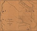
 (Plat of the Great City of the Valley of the Great Salt Lake) LOC 2017587026.jpg 4,328 × 6,503; 2.85 MB
-
 (Plat of the Great City of the Valley of the Great Salt Lake) LOC 2017587026.tif 4,328 × 6,503; 80.52 MB
-

-
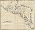 (1847) States forming the REPUBLIC OF CENTRALAMERICA.jpg 977 × 847; 602 KB
-
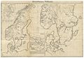 HEINZELMANN(1847) 01.395 Kartenblatt Dänemark, Norwegen, Schweden.jpg 3,961 × 2,745; 5.35 MB
-
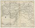 THIRLWALL(1847) p4.006 THE MARCH OF CYRUS.jpg 4,142 × 3,334; 6.19 MB
-
-

-
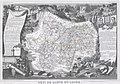 1847 Levasseur Map of Saone et Loire, France - Geographicus - SaoneLoire-levasseur-1847.jpg 3,500 × 2,462; 2.54 MB
-
 1847 Levasseur Map of Sarthe, France - Geographicus - Sarthe-levasseur-1847.jpg 5,177 × 3,631; 4.68 MB
-

-

-

-

-
 1847 Molini Pocket Map of Florence (Frienze), Italy - Geographicus - Firenze-molini-1847.jpg 5,000 × 3,776; 7.78 MB
-
 1847 Passage de l'Esla map.jpg 1,630 × 2,203; 451 KB
-
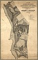
 1847 proposed Boston and Woonsocket railroad routes.jpg 4,992 × 4,176; 4.86 MB
-
 1850 Levasseur Map of Ile de La Reunion - Geographicus - Reunion-levasseur-1850.jpg 4,000 × 2,828; 2.83 MB
-

-

-

-

-
 Albert Lionnet, Das Heilige Land (FL199985556 2368732).jpg 3,216 × 4,144; 19.64 MB
-

-

-
 City of Washington. NYPL434812.tiff 4,736 × 5,547; 75.17 MB
-

-

-

-

-

-

-

-

-

-
 Map of Berk(eley) County, Virginia LOC 2012593053.jpg 3,762 × 4,773; 2.66 MB
-
 Map of Berk(eley) County, Virginia LOC 2012593053.tif 3,762 × 4,773; 51.37 MB
-
 Map of Mexico City region. LOC 00561384.jpg 2,989 × 4,675; 1.39 MB
-
 Map of Mexico City region. LOC 00561384.tif 2,989 × 4,675; 39.98 MB
-
 Map of Servia and the adjoining countries.jpg 2,400 × 1,420; 770 KB
-
 Map of the Chinese empire, compiled from native & foreign authorities LOC 2006629423.jpg 10,780 × 7,528; 16.44 MB
-
 Map of the Chinese empire, compiled from native & foreign authorities LOC 2006629423.tif 10,780 × 7,528; 232.18 MB
-

-

-
-

-

-

-
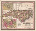 Map of the State of North Carolina showing the gold region 1847.jpg 4,387 × 3,714; 2.91 MB
-
 Map of the United States of America to accompany Doggett's Rail Road Guide. LOC 98688306.jpg 7,160 × 5,500; 7.89 MB
-
 Map of the United States of America to accompany Doggett's Rail Road Guide. LOC 98688306.tif 7,160 × 5,500; 112.67 MB
-
 Map showing coast of Mexico from Vera Cruz to Chuxula LOC 2001624349.jpg 6,034 × 4,141; 2.15 MB
-
 Map showing coast of Mexico from Vera Cruz to Chuxula LOC 2001624349.tif 6,034 × 4,141; 71.49 MB
-

-
 Mappa da Cidade de São Paulo e seus Suburbios (1847).jpg 6,248 × 5,044; 2.78 MB
-
 New Jersey - engraved by J.H. Young. NYPL434590.tiff 4,096 × 6,219; 72.89 MB
-
 Norwalk 1847 Map, CT, 06854, USA.jpg 3,016 × 4,718; 3.2 MB
-
 Nouvelle carte topographique, statistique et routière du département de la Côte-d'Or - 1847.jpg 8,558 × 10,605; 16.31 MB
-
 Nouvelle carte topographique, statistique et routière du département de Saône-et-Loire - 1847.jpg 10,688 × 7,249; 12.67 MB
-
-
 Operations of Genl. Scott's Army on 8th, 12th & 13th Sep. 1847 - (Mexico City) LOC 2001620537.tif 7,042 × 8,482; 170.89 MB
-
 Ornamental map of the United States and Mexico - Barritt sc. NYPL434021.tiff 4,882 × 6,184; 86.38 MB
-
 Pianta della città di Firenze (2674792631).jpg 10,512 × 7,824; 36.39 MB
-
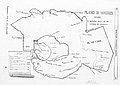
 Plan of Bytown - 1847.jpg 3,530 × 2,777; 1.86 MB
-
 Plan of Genl. Wool's camp at Buena-Vista, August 1847. LOC 2001622532.jpg 5,846 × 4,844; 3.93 MB
-
 Plan of Genl. Wool's camp at Buena-Vista, August 1847. LOC 2001622532.tif 5,846 × 4,844; 81.02 MB
-
 Plan of lots in North Auburn Dale, Newton, Mass. (5121139072).jpg 2,000 × 1,431; 2.41 MB
-

-
 Plan of the fishing town of Percee. Surveyed in 1846.jpg 3,000 × 2,142; 1.53 MB
-
 Plan topographique de la ville de Lyon et de ses environs 1847 rotated.jpg 5,330 × 3,702; 35.02 MB
-
 Plan topographique de la ville de Lyon et de ses environs 1847.pdf 3,700 × 5,329; 67.59 MB
-
 Plan Vaise 1847.png 459 × 729; 901 KB
-
 Plano de Madrid desde su fundación hasta el dia.jpg 3,230 × 2,295; 583 KB
-
 Provincia de São Paulo 1847.jpg 480 × 378; 196 KB
-
 Richard Palmer, Ancient Jerusalem with the land of Moriah (FL45582429 3918623).jpg 2,435 × 1,532; 1.33 MB
-
 Richard Palmer, Half Tribe of Manasseh (FL45582380 3918613).jpg 2,415 × 1,445; 1.25 MB
-
 Richard Palmer, Manasseh beyond Jordan (FL45582352 3918568).jpg 1,521 × 2,368; 1.38 MB
-
 Richard Palmer, Tribe of Asher (FL45582400 3918618).jpg 1,527 × 2,456; 1.22 MB
-
 Richard Palmer, Tribe of Benjamin (FL45582394 3918610).jpg 1,505 × 2,459; 990 KB
-
 Richard Palmer, Tribe of Dan (FL45582377 3918609).jpg 1,515 × 2,493; 856 KB
-
 Richard Palmer, Tribe of Ephraim (FL45582391 3918612).jpg 2,482 × 1,544; 882 KB
-
 Richard Palmer, Tribe of Gad (FL45582343 3918566).jpg 1,489 × 2,434; 1.11 MB
-
 Richard Palmer, Tribe of Issachar (FL45582413 3918614).jpg 2,505 × 1,590; 919 KB
-
 Richard Palmer, Tribe of Judah (FL45582357 3918571).jpg 2,092 × 2,358; 1.45 MB
-
 Richard Palmer, Tribe of Naphtali (FL45582420 3918620).jpg 1,567 × 2,442; 889 KB
-
 Richard Palmer, Tribe of Reuben (FL45582340 3918565).jpg 2,441 × 1,551; 1.35 MB
-
 Richard Palmer, Tribe of Simeon (FL45582360 3918608).jpg 1,584 × 2,494; 864 KB
-
 Richard Palmer, Tribe of Zebulon (FL45582408 3918616).jpg 2,424 × 1,444; 1.26 MB
-
 Schroeder Plan von Berlin 1847.jpg 9,128 × 6,312; 13.65 MB
-
 Secchia Fiume 1847.jpg 2,969 × 973; 634 KB
-
 Sketch of head land in Bytown.jpg 3,495 × 2,273; 1.57 MB
-

-

-
 Stabius map of the world II.jpg 2,191 × 1,646; 2.62 MB
-
 Stabius map of the world.jpg 750 × 596; 156 KB
-
 Stabius-Durer world map.jpg 2,834 × 2,084; 835 KB
-
 T19-1.jpg 12,870 × 9,285; 7.91 MB
-

-

-
 Track of HMSV Grappler from October 1st 1847, to December 31st 1847. RMG F1974.tiff 6,905 × 5,112; 100.99 MB
-

_LOC_2017587026.jpg)
.jpg)
_States_forming_the_REPUBLIC_OF_CENTRALAMERICA.jpg)
_01.395_Kartenblatt_D%C3%A4nemark,_Norwegen,_Schweden.jpg)
_p4.006_THE_MARCH_OF_CYRUS.jpg)
_-_Geographicus_-_IsuIslands-japanese-1730.jpg)


,_Italy_-_Geographicus_-_Firenze-molini-1847_(zona_di_via_dei_bardi).jpg)
,_Italy_-_Geographicus_-_Firenze-molini-1847.jpg)


.jpg)
.jpg)

.jpg)

.jpg)
_(14740510686).jpg)

_County,_Virginia_LOC_2012593053.jpg)


_Rail_Road_Convention_by_James_Herron_Civil_Engineer._LOC_98688674.jpg)


.jpg)
.jpg)


_LOC_2001620537.jpg)
.jpg)


.jpg)
.jpg)


.jpg)
.jpg)
.jpg)
.jpg)
.jpg)
.jpg)
.jpg)
.jpg)
.jpg)
.jpg)
.jpg)
.jpg)
.jpg)
.jpg)


.jpg)