Category:1846 maps
Jump to navigation
Jump to search
| ← · 1840 · 1841 · 1842 · 1843 · 1844 · 1845 · 1846 · 1847 · 1848 · 1849 · → |
Deutsch: Karten mit Bezug zum Jahr 1846
English: Maps related to the year 1846
Español: Mapas relativos al año 1846
Français : Cartes concernant l’an 1846
Русский: Карты 1846 года
Subcategories
This category has the following 8 subcategories, out of 8 total.
Media in category "1846 maps"
The following 95 files are in this category, out of 95 total.
-
 HODGSON(1846) EXPLORATION ROUTE FROM JIMBOUR TO NORTH WEST.jpg 2,237 × 2,703; 2.18 MB
-
 KRUSE(1846) p651 links-oben.jpg 1,926 × 1,152; 768 KB
-
 KRUSE(1846) p655 Map.jpg 5,572 × 4,284; 5.76 MB
-
 KRUSE(1846) p655.2.jpg 1,570 × 1,733; 1.1 MB
-
 KRUSE(1846) p655.3.jpg 1,117 × 1,174; 562 KB
-
 LELEWEL(1846) Polen im Jahr 992.jpg 838 × 809; 622 KB
-
 THIRLWALL(1846) p3.270 THRACE AND THE PROPONTIS.jpg 4,073 × 3,366; 5.96 MB
-

-

-
 1846 Burroughs - Mitchell Map of Kentucky - Geographicus - KT-m-1846.jpg 2,835 × 2,340; 1.84 MB
-
 1846 Burroughs - Mitchell Map of Mississippi - Geographicus - MS-m-1846.jpg 2,340 × 2,854; 1.73 MB
-
 1846 Burroughs - Mitchell Map of Ohio - Geographicus - Ohio-m-1846.jpg 2,854 × 3,500; 2.81 MB
-
 1846 Mitchell - Burroughs Map of South Carolina - Geographicus - SC-m-1846.jpg 3,500 × 2,831; 2.69 MB
-
 1846.Am Kupfergraben 1 8.3068.tif 1,362 × 826; 4.31 MB
-
 1846.Burgstrasse 1 7.3068.tif 1,362 × 826; 4.31 MB
-
 1846.Burgstrasse 21 26.3068.tif 1,362 × 826; 4.31 MB
-
 1846.Burgstrasse 22 29.3068.tif 1,362 × 826; 4.31 MB
-
 1846.Burgstrasse 8 20.3068.tif 1,362 × 826; 4.31 MB
-
 1846.Haackesche Markt.3068.tif 1,362 × 826; 4.31 MB
-

-

-
 A plan of Brunswick village LOC 2010589033.jpg 12,942 × 10,643; 14.21 MB
-
 A plan of Brunswick village LOC 2010589033.tif 12,942 × 10,643; 394.08 MB
-
 A plan or map of the Solar System projected for schools & academies LOC 2013593145.jpg 7,974 × 8,089; 8.25 MB
-
 A plan or map of the Solar System projected for schools & academies LOC 2013593145.tif 7,974 × 8,089; 184.54 MB
-

-
-
 Albany Rural Cemetery - engraved and printed by J.E. Gavit. NYPL434097.tiff 4,163 × 3,503; 41.73 MB
-
 Alte Topo (2).jpg 1,721 × 1,372; 1.71 MB
-

-

-
 Antilles ou Indes Occidentales (2674657483).jpg 2,000 × 1,492; 2.47 MB
-
 Atlas pittoresque carte 01-droite.jpg 2,000 × 3,072; 1.5 MB
-
 Baronies of Ireland 1846.jpg 1,200 × 1,952; 452 KB
-
 Battle of Palo Alto, 8th May 1846. LOC 2001622060.jpg 3,072 × 2,688; 910 KB
-
 Battle of Palo Alto, 8th May 1846. LOC 2001622060.tif 3,072 × 2,688; 23.63 MB
-
 Benjamin Rees Davies, Constantinople - Stambool (FL37469649 2370309).jpg 9,778 × 8,085; 114.2 MB
-

-

-
 Carta dell impero de'Persi diviso in satrapie (FL36567526 3914218).jpg 3,173 × 4,938; 6.99 MB
-
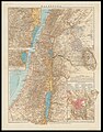
 Carta della Palestina sotto il Dominio de' Romani (FL36566940 3914318).jpg 13,006 × 17,861; 280.04 MB
-
-
 Ch Dyonnet, Mont-Thabor (FL37124110 3899291).jpg 4,584 × 2,823; 4.15 MB
-
 Eclipse of the sun, 1846 - April 25 LOC 2013593158.jpg 9,035 × 7,160; 7.91 MB
-
 Eclipse of the sun, 1846 - April 25 LOC 2013593158.tif 9,035 × 7,160; 185.08 MB
-
 Edward Aldrich, Plan of the town and environs of Jerusalem (FL6881070 2367981).jpg 2,600 × 2,291; 3.39 MB
-

-

-
 Frederick Catherwood, Plan of Jerusalem 1835 (FL45582983 3925922).jpg 2,772 × 3,821; 2.84 MB
-
 Friedrich Carl Ludwig Sickler, Palaestina (FL199985947 2369054).jpg 7,296 × 4,760; 12.54 MB
-

-
 Green-wood cemetery - James Smillie; William Lawrence. NYPL434096.tiff 1,739 × 2,248; 11.21 MB
-
 Hans Fischer, Palästina (FL35058284 2367002).jpg 10,529 × 13,440; 221.17 MB
-

-
 History of Náchod 02 - old town map.JPG 2,782 × 1,976; 4.72 MB
-
 John Betts (fl. 1844-1863), Palestine (FL199985169 2368363).jpg 5,862 × 7,576; 19.39 MB
-
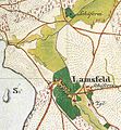 Lamsfeld Urmesstischblatt 4051-1846.jpg 839 × 907; 82 KB
-
 Land taken by Lt. Col. By for the Rideau Canal.jpg 3,501 × 2,828; 1.41 MB
-

-

-
 Mondo degli Ebrei (FL36567521 3914225).jpg 2,872 × 3,950; 7.22 MB
-
 Mount Sion (FL199420628 1145342).jpg 4,651 × 3,878; 16.15 MB
-
 Ning Jun di yu tu. LOC gm71002469.jpg 11,542 × 13,930; 22.05 MB
-
 NRHP Castle Hill on the Crane Estate no 77000183-45.jpg 2,915 × 1,975; 3.57 MB
-
 Parte del reyno de la Na. Espana LOC 2001620539.jpg 5,266 × 3,638; 2.02 MB
-
 Parte del reyno de la Na. Espana LOC 2001620539.tif 5,266 × 3,638; 54.81 MB
-
 Pianta Cittadella 1846.jpg 2,730 × 2,479; 5.96 MB
-
 Plan of Jerusalem (FL163904571 2667379).jpg 5,165 × 4,151; 21.73 MB
-

-

-

-
 Plan of the lands of the Winnisimmet Co. and others in Chelsea & Malden (3369704609).jpg 2,000 × 1,518; 2.97 MB
-
 Plan Sytuacyiny Miasta Łowicz 1846.jpg 2,651 × 2,966; 1.49 MB
-
 Provincias internas del reyno de Nuevo España LOC 2001620544.jpg 7,483 × 9,552; 7.36 MB
-
 Provincias internas del reyno de Nuevo España LOC 2001620544.tif 7,483 × 9,552; 204.5 MB
-

-

-
 Regni di Giudae d'Israele (FL36567492 3914210).jpg 5,035 × 3,195; 6.92 MB
-
 Regno di David e di Salomone e stati circonvicini (FL36567500 3914213).jpg 4,707 × 2,964; 6.25 MB
-
 Royal Commission on Metropolitan Termini Map.jpg 7,372 × 4,598; 31.42 MB
-
 Siria Cipro, Creta Egitto Cirenaica Marmarica ed Arabia.Carta di geografia antica (FL36566265 3913666).jpg 13,771 × 10,393; 189.74 MB
-

-

-

-
 Storozevaya sluzba.jpg 7,380 × 10,540; 11.23 MB
-
 Systemes Geographique de Ptolemee, de Strabon, et d'Eratosthene.jpg 1,600 × 1,185; 336 KB
-

-

-
 The harbor of Annapolis LOC 2008625101.jpg 5,766 × 4,843; 3.07 MB
-
 The harbor of Annapolis LOC 2008625101.tif 5,766 × 4,843; 79.89 MB
-

-
 WALSDORF.jpg 1,311 × 1,134; 1.26 MB
-
 Wilhelm Ludwig Krafft, Plan von Jerusalem (FL6882018 2531353).jpg 2,170 × 2,899; 3.1 MB
-
 Wutaishan sheng jing quan tu LOC gm71005058.jpg 10,566 × 13,794; 25.73 MB
-
 Wutaishan sheng jing quan tu LOC gm71005058.tif 10,566 × 13,794; 416.99 MB
_EXPLORATION_ROUTE_FROM_JIMBOUR_TO_NORTH_WEST.jpg)
_p651_links-oben.jpg)
_p655_Map.jpg)
_p655.2.jpg)
_p655.3.jpg)
_Polen_im_Jahr_992.jpg)
_p3.270_THRACE_AND_THE_PROPONTIS.jpg)
_-_Geographicus_-_CollectPond-hutchings-1846_(cropped).jpg)
_-_Geographicus_-_CollectPond-hutchings-1846.jpg)


.jpg)

.jpg)


.jpg)

.jpg)
.jpg)

.jpg)

.jpg)

.jpg)
.jpg)
.jpg)
_(14744462196).jpg)

,_Palestine_(FL199985169_2368363).jpg)


.jpg)
.jpg)


.jpg)
.jpg)
_between_the_Rio_Bravo_%26_the_Arroyo_Colorado_LOC_2001622057.jpg)
.jpg)


.jpg)
.jpg)

.jpg)

.jpg)


.jpg)
