Category:1843 maps
Jump to navigation
Jump to search
| ← · 1840 · 1841 · 1842 · 1843 · 1844 · 1845 · 1846 · 1847 · 1848 · 1849 · → |
Deutsch: Karten mit Bezug zum Jahr 1843
English: Maps related to the year 1843
Español: Mapas relativos al año 1843
Français : Cartes concernant l’an 1843
Русский: Карты 1843 года
Subcategories
This category has the following 9 subcategories, out of 9 total.
Media in category "1843 maps"
The following 127 files are in this category, out of 127 total.
-
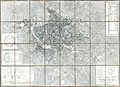
 BECHSTEIN(1843) p142 Plan der Kaiserlichen Residenz-Stadt Wien.jpg 4,530 × 2,938; 6.7 MB
-
 CHERTKOV(1843) p010 Оборона Доростола.jpg 3,064 × 2,360; 3.55 MB
-
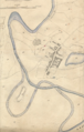
 1843 kart Bergeland.jpg 3,072 × 2,304; 2.48 MB
-
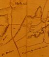 1843 kart over Hetland prestegård P1090500.JPG 479 × 566; 140 KB
-
-
 1843 Monaldini Case Map of Rome, Italy - Geographicus - Rome-monaldini-1843.jpg 6,000 × 4,350; 8.31 MB
-
 1843 Paradis kart.png 569 × 624; 259 KB
-

-
 Albany. NYPL434581.tiff 4,648 × 5,283; 70.26 MB
-
 Alnmouth Tithe Map 1843.png 954 × 1,494; 2.54 MB
-
-
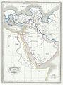
 Auguste Henri Dufour, La Terre Sainte (FL49973501 4073162).jpg 6,220 × 8,040; 69.44 MB
-
 Australia and Papua are Melanesia.jpg 897 × 634; 500 KB
-
 Benjamin Rees Davies, Plan of St. Jean d'Acre. 1799 (FL6882373 2468867).jpg 3,163 × 1,950; 2.08 MB
-
 Bulletin de la Société Impériale des Naturalistes de Moscou (1843) (20248151978).jpg 3,686 × 2,096; 954 KB
-
 Cantonment St. Thomas Mount 1843.jpg 3,819 × 3,433; 15.34 MB
-
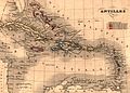 Carte antilles 1843.jpg 2,850 × 2,043; 2.59 MB
-
 Causton’s 1843 map of Gloucester.jpg 3,300 × 2,550; 1.78 MB
-
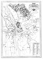
 Centre Division India 1843.jpg 2,074 × 2,552; 4.15 MB
-
 China Sheet VIII.jpg 961 × 1,440; 220 KB
-

-
 China, sheet VII - eastern coast from the Phi-Ki-Shan to the Hie-Shan Islands LOC 2007629465.tif 7,634 × 5,883; 128.49 MB
-
 Christiaenssens.jpg 583 × 800; 102 KB
-
 City wall of Qingyuan, Zhejiang in 1843.jpg 3,547 × 2,496; 2.9 MB
-
 Clara Filleul, Palestine (FL45612670 3959697).jpg 3,097 × 2,457; 3.82 MB
-
 Diagram of the surveying district, south of Tennessee - (Mississippi). LOC 92684625.jpg 6,256 × 8,471; 5.99 MB
-
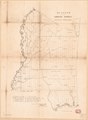 Diagram of the surveying district, south of Tennessee - (Mississippi). LOC 92684625.tif 6,256 × 8,471; 151.62 MB
-

-
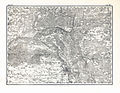
 General-Karte des Königreichs Illyrien nebst dem Königlich Ungarischen Littorale 1843.jpg 10,338 × 13,256; 113.39 MB
-
 Grätz 1843.jpg 3,718 × 5,070; 8.24 MB
-
 Hodkovice cadastral map 1843.jpg 3,000 × 3,000; 4.05 MB
-
 James Wyld, Map of the Ottoman Dominions in Asia (FL36010565 2715309).jpg 18,780 × 14,200; 383.84 MB
-

-
 Julian Symonds, Plan of Caiffa (FL165784887 2468892).jpg 2,882 × 3,641; 6.72 MB
-
 Julian Symonds, Special reconnoissance of Gaza (FL27950508 2468885).jpg 5,283 × 6,143; 38.77 MB
-
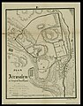
 Karl Johannes Ball, Plan von Jerusalem (FL6882227 2366845).jpg 2,800 × 2,218; 2.07 MB
-
 Karte von China und Japan den Manen D'Anville's und Klapproth's LOC 2006635533.jpg 15,643 × 10,700; 34.24 MB
-
 Karte von China und Japan den Manen D'Anville's und Klapproth's LOC 2006635533.tif 15,643 × 10,700; 478.88 MB
-
 Kexholm 1843.jpg 2,955 × 2,295; 1.81 MB
-
 Kingstone. NYPL434570.tiff 4,672 × 5,171; 69.12 MB
-
 Ktkp.jpg 1,200 × 933; 530 KB
-
 Lajjun Sanjak in Ottoman Palestine.png 1,930 × 2,359; 9.97 MB
-
 Lieut. C. F. Skyring, Jaffa & vicinity (FL6880887 2468890).jpg 3,166 × 1,950; 2.1 MB
-
 Lion United Kingdom 1843 Counties.jpg 1,344 × 1,888; 2.8 MB
-

-
 Louny, plán města na císařském otisku mapy stabilního katastru, 1843.png 4,181 × 2,603; 669 KB
-

-
-

-
 M. Cardelli, Tableau historique et géographique de l'histoire sacrée (FL63912755 2514499).jpg 15,794 × 11,304; 200.14 MB
-
 M. Cardelli, Tableau historique et géographique de la Grèce ancienne (FL63912734 2514500).jpg 15,798 × 11,334; 205 MB
-
 Map of Canaan or Palestine (FL46962015 3902708).jpg 1,965 × 2,488; 4.01 MB
-

-

-

-

-

-

-

-
 Map of Paris 1843 pari000126.jpg 2,768 × 1,596; 7.47 MB
-
 Map of the city of Albany (8347361684).jpg 800 × 531; 96 KB
-

-
 Map of the District North of Red River & North Western District, La. LOC 83695471.jpg 3,289 × 2,845; 1.05 MB
-
 Map of the District North of Red River & North Western District, La. LOC 83695471.tif 3,289 × 2,845; 26.77 MB
-
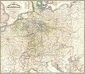 Map Thurn-und-Taxis-Post.jpg 3,676 × 3,171; 3.78 MB
-

-

-
 Narrative of a Voyage around the World - Map of Canton River.jpg 2,495 × 2,434; 377 KB
-
 Narrative of a Voyage around the World - Map, showing the track of ground searched.jpg 3,630 × 1,668; 437 KB
-

-

-
 Palaestina (FL32713934 3878212).jpg 7,907 × 9,722; 79.58 MB
-
 Palestine with the Hauran and the adjacent districts, William Hughes 1843.jpg 6,162 × 7,150; 8.6 MB
-

-
-
 Plano de la parte austral del Istmo de Tehuantepec (1843).jpg 2,864 × 3,503; 1.05 MB
-

-
 Sketch of the Battle of Bunker Hill (2674266417).jpg 2,000 × 1,475; 2.01 MB
-
 Smoler korta01.jpg 1,539 × 2,202; 2.75 MB
-

-

-

-

-

-

-

-
-
-
-

-

-
-
-
-

-

-

-
-
-

-
-

-

-

-

-

-

-

-
-
 Special-Karte des Herzogthums Krain 1843 (part 6).jpg 5,000 × 3,836; 9.23 MB
-
 St. Helena District, La. LOC 83695470.jpg 2,842 × 1,853; 694 KB
-
 St. Helena District, La. LOC 83695470.tif 2,842 × 1,853; 15.07 MB
-
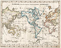 StielerWorld.jpeg 2,798 × 2,233; 964 KB
-
 Sveits - no-nb krt 00924.jpg 9,122 × 7,647; 26.81 MB
-
 Temperance Map, 1843, by C. Wilthberger.jpg 3,811 × 4,000; 4.72 MB
-
 The Artizan (1843) (14578516099).jpg 2,350 × 3,492; 1.7 MB
-
 The Fort in New Yorke - (drawn from memory by the Reverend John Miller). NYPL434562.tiff 4,845 × 4,989; 69.16 MB
-
 The Fort of Albany. NYPL434569.tiff 4,648 × 5,323; 70.79 MB
-

-
 Thierry, Empire d'Alexandre (FL33131058 2490321).jpg 10,196 × 6,550; 83.22 MB
-
 Thos Scott (of the) Wager Ward (at Greenwich Hospital) RMG PU3532.tiff 2,076 × 3,287; 19.52 MB
-
 United Kingdom 1843.jpg 2,482 × 3,404; 3.55 MB
-
 William Hughes, Ancient Syria (FL13729645 2515295).jpg 5,477 × 6,596; 47.81 MB
-
 William Hughes, Palestine with the Hauran and the adjacent districts (FL35081136 3890409).jpg 8,315 × 10,127; 114.61 MB
-
 William Hughes, Syria (FL13729654 2516150).jpg 5,655 × 6,633; 50.12 MB
-
 William Whiston, Palestine as divided among the tribes and plan of Jerusalem (FL35084142 3890542).jpg 6,503 × 12,308; 113.22 MB
-
 Zagorzyce TKKP 3 8.jpg 1,890 × 1,488; 1 MB
_p142_Plan_der_Kaiserlichen_Residenz-Stadt_Wien.jpg)
_p010_%D0%9E%D0%B1%D0%BE%D1%80%D0%BE%D0%BD%D0%B0_%D0%94%D0%BE%D1%80%D0%BE%D1%81%D1%82%D0%BE%D0%BB%D0%B0.jpg)


_-_Geographicus_-_Hebreux-maltebrun-1837.jpg)


.jpg)
.jpg)

.jpg)
_(20248151978).jpg)


.jpg)
._LOC_92684625.jpg)
.jpg)


.jpg)
.jpg)
.jpg)
.jpg)
.jpg)


.jpg)

.jpg)

.jpg)
.jpg)
.jpg)
.jpg)
.jpg)
.jpg)


.jpg)

.jpg)
_for_the_extension_of_the_Baltimore_%26_Ohio_Rail_Road_to_its_western_terminus_LOC_98688590.jpg)


._LOC_88693301.jpg)
.jpg)


_Barry_Lawrence_Ruderman_Antique_Maps_Inc.jpg)
.jpg)
.jpg)
.jpg)

._Turkish_Empire,_Greece._1843.B.jpg)
._Turkish_Empire,_Greece._1843.C.jpg)
._Turkish_Empire,_Greece._1843.CA.jpg)
._Turkish_Empire,_Greece._1843.CB.jpg)
._Turkish_Empire,_Greece._1843.CC.jpg)
._Turkish_Empire,_Greece._1843.CD.jpg)
._Turkish_Empire,_Greece._1843.D.jpg)
._Turkish_Empire,_Greece._1843.DA.jpg)
._Turkish_Empire,_Greece._1843.DB.jpg)
._Turkish_Empire,_Greece._1843.DC.jpg)
._Turkish_Empire,_Greece._1843.DD.jpg)
._Turkish_Empire,_Greece._1843.E.jpg)
._Turkish_Empire,_Greece._1843.EA.jpg)
._Turkish_Empire,_Greece._1843.EB.jpg)
._Turkish_Empire,_Greece._1843.EC.jpg)
._Turkish_Empire,_Greece._1843.ED.jpg)
._Turkish_Empire,_Greece._1843.F.jpg)
._Turkish_Empire,_Greece._1843.FA.jpg)
._Turkish_Empire,_Greece._1843.FB.jpg)
._Turkish_Empire,_Greece._1843.G.jpg)
._Turkish_Empire,_Greece._1843.GA.jpg)
._Turkish_Empire,_Greece._1843.GB.jpg)
._Turkish_Empire,_Greece._1843.GC.jpg)
._Turkish_Empire,_Greece._1843.GD.jpg)
._Turkish_Empire,_Greece._1843.GE.jpg)
._Turkish_Empire,_Greece._1843.GF.jpg)
._Turkish_Empire,_Greece._1843.GG.jpg)
._Turkish_Empire,_Greece._1843.H.jpg)
._Turkish_Empire,_Greece._1843.HA.jpg)
._Turkish_Empire,_Greece._1843.HB.jpg)
.jpg)


_(14578516099).jpg)
_schools,_geographical_%26_historical_lectures,_and_missionary_meetings_(5489515269).jpg)
.jpg)

.jpg)
.jpg)
.jpg)
.jpg)
