Category:Maps of the history of West Virginia
Jump to navigation
Jump to search
States of the United States: Alabama · Alaska · Arizona · Arkansas · California · Colorado · Connecticut · Delaware · Florida · Georgia · Hawaii · Idaho · Illinois · Indiana · Iowa · Kansas · Kentucky · Louisiana · Maine · Maryland · Massachusetts · Michigan · Minnesota · Mississippi · Missouri · Montana · Nebraska · Nevada · New Hampshire · New Jersey · New Mexico · New York · North Carolina · North Dakota · Ohio · Oklahoma · Oregon · Pennsylvania · Rhode Island · South Carolina · South Dakota · Tennessee · Texas · Utah · Vermont · Virginia · Washington · West Virginia · Wisconsin · Wyoming – Washington, D.C.
Puerto Rico
Puerto Rico
Subcategories
This category has only the following subcategory.
Media in category "Maps of the history of West Virginia"
The following 5 files are in this category, out of 5 total.
-
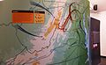 "An American Turning Point- The Civil War in Virginia (16864672811).jpg 4,226 × 2,592; 4.1 MB
-
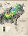 1860-61 Secession in Appalachia by County.jpg 1,887 × 2,393; 1.82 MB
-
 Fort Ancient Monongahela cultures HRoe 2010.jpg 700 × 496; 312 KB
-
 Proposed state of kanawha.jpg 750 × 500; 105 KB
-
 West Virginia regions 1863.jpg 6,587 × 5,100; 2.69 MB
.jpg)


