Category:Maps of the history of Washington (state)
Jump to navigation
Jump to search
States of the United States: Alabama · Alaska · Arizona · Arkansas · California · Colorado · Connecticut · Delaware · Florida · Georgia · Hawaii · Idaho · Illinois · Indiana · Iowa · Kansas · Kentucky · Louisiana · Maine · Maryland · Massachusetts · Michigan · Minnesota · Mississippi · Missouri · Montana · Nebraska · Nevada · New Hampshire · New Jersey · New Mexico · New York · North Carolina · North Dakota · Ohio · Oklahoma · Oregon · Pennsylvania · Rhode Island · South Carolina · South Dakota · Tennessee · Texas · Utah · Vermont · Virginia · Washington · West Virginia · Wisconsin · Wyoming – Washington, D.C.
Puerto Rico
Puerto Rico
Subcategories
This category has only the following subcategory.
Media in category "Maps of the history of Washington (state)"
The following 34 files are in this category, out of 34 total.
-
 1846 Oregon territory.jpg 2,218 × 2,010; 1,021 KB
-
 1872 North Cascades Isoseismal Map.png 1,464 × 1,544; 508 KB
-
 Benton County Washington Incorporated and Unincorporated areas.svg 950 × 800; 105 KB
-
 Black Diamond Historical Museum - immigration map 01.jpg 5,384 × 3,729; 5.58 MB
-
 Bonneville Landslide, Bridge of the Gods.jpg 10,800 × 10,800; 42.66 MB
-
 Chinook.png 1,497 × 1,101; 2.43 MB
-
 Coeur d'Alene Tribe.jpg 640 × 500; 74 KB
-
 Cooperative economic insect report (1957) (20698078925).jpg 3,442 × 2,206; 2.07 MB
-
 EB9 United States - historical maps (bottom).jpg 2,501 × 2,000; 942 KB
-
 FtWWFtColvRedMap.jpg 1,008 × 2,706; 341 KB
-
 Initiative 692 Results.png 800 × 521; 111 KB
-
 Map from Indian land cessions in the United States by Charles C. Royce 60.jpg 4,256 × 3,297; 4.18 MB
-

-

-
 Map of World War II Japanese American internment camps.png 896 × 744; 105 KB
-
 Nisqually Earthquake ShakeMap Oct 13 2003.jpg 612 × 710; 236 KB
-

-
 Oregon & Washington Territories 1853.svg 701 × 621; 239 KB
-
 Oregon boundary dispute map.PNG 606 × 599; 106 KB
-
 Oregon State & Washington Territory 1859.svg 701 × 621; 249 KB
-
 Oregon State & Washington Territory 1863.svg 701 × 621; 236 KB
-
 Oregon Territory 1848.svg 701 × 621; 218 KB
-
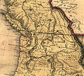
 OregonCountry.jpg 1,097 × 769; 31 KB
-
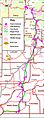
 Pacific Northwest Military Outposts.jpg 683 × 473; 149 KB
-
 Tacoma Earthquake-APR-29-1965.png 612 × 687; 74 KB
-
 Vancouver National Historic Reserve ownership map 2003.jpg 1,146 × 711; 429 KB
-
 Wpdms oregon territory 1848.png 285 × 219; 4 KB
-
 Wpdms oregon territory 1859 detail.jpg 275 × 208; 8 KB
-
 Wpdms oregon washington territories 1853.png 285 × 219; 31 KB
-
 Wpdms oregon washington territory 1859.png 285 × 219; 29 KB
-
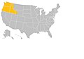
 Wpdms washington dakota territories 1861.idx.png 232 × 168; 10 KB
-
 Wpdms washington idaho territories 1863.png 270 × 200; 25 KB
-
 Wpdms washington territory 1863 legend 3.png 285 × 272; 22 KB
-
 York-Factory-Express.png 876 × 593; 142 KB


_(20698078925).jpg)
.jpg)


.jpg)


