Category:Maps of the American Battlefield Protection Program West Virginia
Jump to navigation
Jump to search

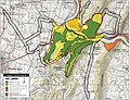
The American Battlefield Protection Program (ABPP) is a US federal government program implemented by the National Park Service of the Department of the Interior with the aim of preserving historic battlefields in the United States. Maps in this category display battlefield core and study areas, existing and potential national register boundaries.
Media in category "Maps of the American Battlefield Protection Program West Virginia"
The following 18 files are in this category, out of 18 total.
-
 Antietam Battlefield Maryland.jpg 1,420 × 1,870; 966 KB
-
 Camp Allegheny Battlefield West Virginia.jpg 1,230 × 1,600; 873 KB
-
 Carnifex Ferry Battlefield West Virginia.jpg 1,275 × 1,650; 659 KB
-
 Cheat Mountain Battlefield West Virginia.jpg 1,650 × 1,270; 626 KB
-
 Droop Mountain Battlefield West Virginia.jpg 1,210 × 1,590; 790 KB
-
 Greenbrier River Battlefield West Virginia.jpg 1,190 × 1,570; 647 KB
-
 Hancock Battlefield Maryland.jpg 1,410 × 1,840; 1.02 MB
-
 Harpers Ferry Battlefield West Virginia.jpg 1,610 × 1,240; 847 KB
-
 Hoke's Run Battlefield West Virginia.jpg 1,200 × 1,580; 917 KB
-
 Kessler's Cross Lanes Battlefield West Virginia.jpg 1,180 × 1,560; 872 KB
-
 Moorefield Battlefield West Virginia.jpg 840 × 1,100; 489 KB
-
 Philippi Battlefield West Virginia.jpg 860 × 1,120; 601 KB
-
 Princeton Courthouse Battlefield West Virginia.jpg 840 × 1,100; 483 KB
-
 Rich Mountain Battlefield West Virginia.jpg 1,220 × 1,580; 859 KB
-
 Shepherdstown Battlefield West Virginia.jpg 1,180 × 1,560; 730 KB
-
 Smithfield Crossing Battlefield West Virginia.jpg 1,570 × 1,200; 748 KB
-
 Summit Point Battlefield West Virginia.jpg 1,590 × 1,250; 812 KB
-
 Williamsport Battlefield Maryland.jpg 1,840 × 2,700; 1.98 MB


