Category:1898 maps of North Dakota
Jump to navigation
Jump to search
States of the United States: Alaska · California · Connecticut · Florida · Georgia · Illinois · Iowa · Kentucky · Louisiana · Maine · Maryland · Massachusetts · Michigan · Minnesota · Mississippi · Missouri · Montana · New Hampshire · New Jersey · New Mexico · New York · North Carolina · North Dakota · Ohio · Oklahoma · Oregon · Pennsylvania · Rhode Island · South Carolina · South Dakota · Tennessee · Texas · Vermont · Virginia · Washington · West Virginia · Wisconsin – Washington, D.C.
Puerto Rico
Puerto Rico
| 1890 1892 1893 1896 1897 1898 → |
Subcategories
This category has the following 6 subcategories, out of 6 total.
S
Media in category "1898 maps of North Dakota"
The following 5 files are in this category, out of 5 total.
-
-
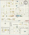
 Sanborn Fire Insurance Map from Carrington, Foster County, North Dakota. LOC sanborn06527 003.tif 6,510 × 7,707; 143.55 MB
-

-
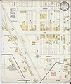
 Sanborn Fire Insurance Map from Lakota, Nelson County, North Dakota. LOC sanborn06545 001.tif 6,510 × 7,707; 143.55 MB
-