Category:1898 maps of California
Jump to navigation
Jump to search
States of the United States: Alaska · California · Connecticut · Florida · Georgia · Illinois · Iowa · Kentucky · Louisiana · Maryland · Michigan · Minnesota · Mississippi · Missouri · Montana · New Jersey · New Mexico · New York · North Carolina · North Dakota · Ohio · Oklahoma · Oregon · Pennsylvania · South Carolina · South Dakota · Tennessee · Texas · Virginia · Washington · West Virginia · Wisconsin – Washington, D.C.
Puerto Rico
Puerto Rico
| ← 1890 1891 1892 1893 1894 1895 1896 1897 1898 1899 → |
Subcategories
This category has the following 20 subcategories, out of 20 total.
C
J
N
S
Media in category "1898 maps of California"
The following 114 files are in this category, out of 114 total.
-
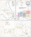
 Angels Hotel plan 1898 from Sanborn Fire Insurance Map.jpg 1,244 × 989; 586 KB
-
-
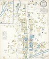
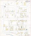
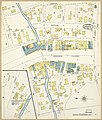
 Sanborn Fire Insurance Map from Angels Camp, Calaveras County, California. LOC sanborn00386 003.tif 6,450 × 7,650; 141.17 MB
-

-
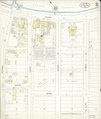
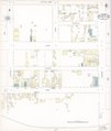
 Sanborn Fire Insurance Map from Avalon, Los Angeles County, California. LOC sanborn00399 002-1.tif 6,450 × 7,650; 141.17 MB
-

-
 Sanborn Fire Insurance Map from Avalon, Los Angeles County, California. LOC sanborn00399 002-2.tif 6,450 × 7,650; 141.17 MB
-

-
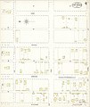
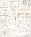
 Sanborn Fire Insurance Map from Caspar, Mendocino County, California. LOC sanborn00452 002.tif 6,450 × 7,650; 141.17 MB
-

-
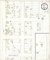
 Sanborn Fire Insurance Map from Fort Bragg, Mendocino County, California. LOC sanborn00551 003-1.tif 6,450 × 7,650; 141.17 MB
-

-
 Sanborn Fire Insurance Map from Fort Bragg, Mendocino County, California. LOC sanborn00551 003-2.tif 6,450 × 7,650; 141.17 MB
-

-
 Sanborn Fire Insurance Map from Fort Bragg, Mendocino County, California. LOC sanborn00551 003-3.tif 6,450 × 7,650; 141.17 MB
-
-
 Sanborn Fire Insurance Map from Fort Bragg, Mendocino County, California. LOC sanborn00551 003-4.tif 6,450 × 7,650; 141.17 MB
-

-
 Sanborn Fire Insurance Map from Fort Bragg, Mendocino County, California. LOC sanborn00551 003-5.tif 6,450 × 7,650; 141.17 MB
-

-
 Sanborn Fire Insurance Map from Fort Bragg, Mendocino County, California. LOC sanborn00551 003-6.tif 6,450 × 7,650; 141.17 MB
-

-
 Sanborn Fire Insurance Map from Fort Bragg, Mendocino County, California. LOC sanborn00551 003-7.tif 6,450 × 7,650; 141.17 MB
-

-
 Sanborn Fire Insurance Map from Geyserville, Sonoma County, California. LOC sanborn00565 001.tif 6,450 × 7,650; 141.17 MB
-

-

-
 Sanborn Fire Insurance Map from Ione, Amador County, California. LOC sanborn00606 002-1.tif 6,450 × 7,650; 141.17 MB
-
 Sanborn Fire Insurance Map from Ione, Amador County, California. LOC sanborn00606 002-2.jpg 6,450 × 7,650; 2.67 MB
-
 Sanborn Fire Insurance Map from Ione, Amador County, California. LOC sanborn00606 002-2.tif 6,450 × 7,650; 141.17 MB
-
 Sanborn Fire Insurance Map from Ione, Amador County, California. LOC sanborn00606 002-3.jpg 6,450 × 7,650; 2.92 MB
-
 Sanborn Fire Insurance Map from Ione, Amador County, California. LOC sanborn00606 002-3.tif 6,450 × 7,650; 141.17 MB
-
 Sanborn Fire Insurance Map from Ione, Amador County, California. LOC sanborn00606 002-4.jpg 6,450 × 7,650; 2.83 MB
-
 Sanborn Fire Insurance Map from Ione, Amador County, California. LOC sanborn00606 002-4.tif 6,450 × 7,650; 141.17 MB
-

-

-

-

-

-

-

-

-

-

-

-

-

-

-

-
 Sanborn Fire Insurance Map from Mendocino, Mendocino County, California. LOC sanborn00678 002-1.tif 6,450 × 7,650; 141.17 MB
-

-
 Sanborn Fire Insurance Map from Mendocino, Mendocino County, California. LOC sanborn00678 002-2.tif 6,450 × 7,650; 141.17 MB
-

-
 Sanborn Fire Insurance Map from Mendocino, Mendocino County, California. LOC sanborn00678 002-3.tif 6,450 × 7,650; 141.17 MB
-

-
 Sanborn Fire Insurance Map from Mendocino, Mendocino County, California. LOC sanborn00678 002-4.tif 6,450 × 7,650; 141.17 MB
-

-
 Sanborn Fire Insurance Map from Mendocino, Mendocino County, California. LOC sanborn00678 002-5.tif 6,450 × 7,650; 141.17 MB
-

-
 Sanborn Fire Insurance Map from Mendocino, Mendocino County, California. LOC sanborn00678 002-6.tif 6,450 × 7,650; 141.17 MB
-

-
 Sanborn Fire Insurance Map from Mendocino, Mendocino County, California. LOC sanborn00678 002-7.tif 6,450 × 7,650; 141.17 MB
-
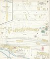
 Sanborn Fire Insurance Map from Reedley, Fresno County, California. LOC sanborn00784 003-1.tif 6,450 × 7,650; 141.17 MB
-

-
 Sanborn Fire Insurance Map from Reedley, Fresno County, California. LOC sanborn00784 003-2.tif 6,450 × 7,650; 141.17 MB
-

-
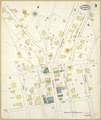
 Sanborn Fire Insurance Map from Dinuba, Tulare County, California. LOC sanborn00503 002.tif 6,450 × 7,650; 141.17 MB
-

-
 Sanborn Fire Insurance Map from Dutch Flat, Placer County, California. LOC sanborn00513 002.tif 6,450 × 7,650; 141.17 MB
-

-
 Sanborn Fire Insurance Map from Greenwood, Mendocino County, California. LOC sanborn00575 003.tif 6,450 × 7,650; 141.17 MB
-
-

-

-

-
 Sanborn Fire Insurance Map from Los Alamitos, Orange County, California. LOC sanborn00653 001.tif 6,450 × 7,650; 141.17 MB
-

-

-
 Sanborn Fire Insurance Map from Niles, Alameda County, California. LOC sanborn00718 002.jpg 6,450 × 7,650; 2.84 MB
-
 Sanborn Fire Insurance Map from Niles, Alameda County, California. LOC sanborn00718 002.tif 6,450 × 7,650; 141.17 MB
-

-

-

-
 Sanborn Fire Insurance Map from San Andreas, Calaveras County, California. LOC sanborn00803 003.tif 6,450 × 7,650; 141.17 MB
-
 Sanborn Fire Insurance Map from Westport, Mendocino County, California. LOC sanborn00927 002.jpg 8,678 × 10,285; 6.28 MB
-
 Sanborn Fire Insurance Map from Westport, Mendocino County, California. LOC sanborn00927 002.tif 8,678 × 10,285; 255.36 MB
-
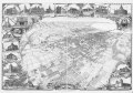
 Santa Barbara, California 1898. LOC 75693115.jpg 11,232 × 7,888; 16.71 MB
-
 Santa Barbara, California 1898. LOC 75693115.tif 11,232 × 7,888; 84.49 MB
-

-
 Sanborn Fire Insurance Map from Sonora, Tuolumne County, California. LOC sanborn00859 003-1.tif 8,844 × 10,475; 265.05 MB
-
 Sanborn Fire Insurance Map from Sonora, Tuolumne County, California. LOC sanborn00859 003-2.jpg 8,831 × 10,443; 7.53 MB
-
 Sanborn Fire Insurance Map from Sonora, Tuolumne County, California. LOC sanborn00859 003-2.tif 8,831 × 10,443; 263.85 MB
-
 Sanborn Fire Insurance Map from Sonora, Tuolumne County, California. LOC sanborn00859 003-3.jpg 8,867 × 10,448; 7.85 MB
-
 Sanborn Fire Insurance Map from Sonora, Tuolumne County, California. LOC sanborn00859 003-3.tif 8,867 × 10,448; 265.05 MB
-
 Sanborn Fire Insurance Map from Sonora, Tuolumne County, California. LOC sanborn00859 003-4.jpg 8,816 × 10,459; 7.99 MB
-
 Sanborn Fire Insurance Map from Sonora, Tuolumne County, California. LOC sanborn00859 003-4.tif 8,816 × 10,459; 263.81 MB
-
 Sanborn Fire Insurance Map from Sonora, Tuolumne County, California. LOC sanborn00859 003-5.jpg 8,831 × 10,457; 7.24 MB
-
 Sanborn Fire Insurance Map from Sonora, Tuolumne County, California. LOC sanborn00859 003-5.tif 8,831 × 10,457; 264.2 MB
-
 Sanborn Fire Insurance Map from Sonora, Tuolumne County, California. LOC sanborn00859 003-6.jpg 8,834 × 10,468; 6.86 MB
-
 Sanborn Fire Insurance Map from Sonora, Tuolumne County, California. LOC sanborn00859 003-6.tif 8,834 × 10,468; 264.57 MB
-
 Sanborn Fire Insurance Map from Stent, Tuolomne County, California. LOC sanborn00866 001-1.jpg 8,811 × 10,439; 8.03 MB
-
 Sanborn Fire Insurance Map from Stent, Tuolomne County, California. LOC sanborn00866 001-1.tif 8,811 × 10,439; 263.15 MB
-
 Sanborn Fire Insurance Map from Stent, Tuolomne County, California. LOC sanborn00866 001-2.jpg 8,818 × 10,478; 6.83 MB
-
 Sanborn Fire Insurance Map from Stent, Tuolomne County, California. LOC sanborn00866 001-2.tif 8,818 × 10,478; 264.34 MB
-

-
 Sanborn Fire Insurance Map from Truckee, Nevada County, California. LOC sanborn00895 003-1.tif 6,450 × 7,650; 141.17 MB
-

-
 Sanborn Fire Insurance Map from Truckee, Nevada County, California. LOC sanborn00895 003-2.tif 6,450 × 7,650; 141.17 MB
-

-
 Sanborn Fire Insurance Map from Truckee, Nevada County, California. LOC sanborn00895 003-3.tif 6,450 × 7,650; 141.17 MB
-

-
 Sanborn Fire Insurance Map from Truckee, Nevada County, California. LOC sanborn00895 003-4.tif 6,450 × 7,650; 141.17 MB
-

-
 Sanborn Fire Insurance Map from Truckee, Nevada County, California. LOC sanborn00895 003-5.tif 6,450 × 7,650; 141.17 MB


