Category:1898 maps of West Virginia
Jump to navigation
Jump to search
States of the United States: Alaska · California · Connecticut · Florida · Georgia · Illinois · Iowa · Kentucky · Louisiana · Maryland · Michigan · Minnesota · Mississippi · Missouri · Montana · New Jersey · New Mexico · New York · North Carolina · North Dakota · Ohio · Oklahoma · Oregon · Pennsylvania · South Carolina · South Dakota · Tennessee · Texas · Virginia · Washington · West Virginia · Wisconsin – Washington, D.C.
Puerto Rico
Puerto Rico
| 1890 1894 1895 1896 1897 1898 1899 → |
Subcategories
This category has the following 8 subcategories, out of 8 total.
S
Media in category "1898 maps of West Virginia"
The following 7 files are in this category, out of 7 total.
-
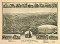 Clarksburg, West Virginia 1898. LOC 75696677.jpg 8,656 × 6,352; 13.23 MB
-
 Clarksburg, West Virginia 1898. LOC 75696677.tif 8,656 × 6,352; 157.31 MB
-
 Davis, Tucker County, West Virginia 1898. LOC 75696678.jpg 8,384 × 5,848; 9.46 MB
-
 Davis, Tucker County, West Virginia 1898. LOC 75696678.tif 8,384 × 5,848; 140.28 MB
-
 Grafton, West Virginia 1898. LOC 75696682.jpg 8,832 × 6,432; 11.46 MB
-

-


