Category:1870s maps of New Hampshire
Jump to navigation
Jump to search
States of the United States: Alabama · Alaska · Arkansas · California · Colorado · Connecticut · Delaware · Florida · Georgia · Hawaii · Idaho · Illinois · Indiana · Iowa · Kansas · Kentucky · Louisiana · Maine · Maryland · Massachusetts · Michigan · Minnesota · Mississippi · Missouri · Montana · Nebraska · Nevada · New Hampshire · New Jersey · New Mexico · New York · North Carolina · North Dakota · Ohio · Oklahoma · Oregon · Pennsylvania · Rhode Island · South Carolina · South Dakota · Tennessee · Texas · Utah · Vermont · Virginia · Washington · West Virginia · Wisconsin · Wyoming – Washington, D.C.
Puerto Rico
Puerto Rico
Subcategories
This category has the following 3 subcategories, out of 3 total.
- 1874 maps of New Hampshire (2 F)
- 1877 maps of New Hampshire (1 F)
- 1878 maps of New Hampshire (1 F)
Media in category "1870s maps of New Hampshire"
The following 21 files are in this category, out of 21 total.
-
 Leavitt's map with views of the White Mountains, New Hampshire - 1871 LOC 94683177.jpg 10,898 × 7,354; 11.42 MB
-

-
 (New Hampshire election district maps) LOC 78692945.jpg 8,229 × 5,113; 6.02 MB
-
 (New Hampshire election district maps) LOC 78692945.tif 8,229 × 5,113; 120.38 MB
-

-
 Carter's New Hampshire diagraphical chart of senatorial districts LOC 99462705.jpg 2,753 × 4,883; 1.97 MB
-

-

-
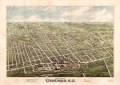
 Bird's eye view of Concord, N.H. - 1875 LOC 2015586191.jpg 9,859 × 7,032; 12.85 MB
-
 Bird's eye view of Concord, N.H. - 1875 LOC 2015586191.tif 9,859 × 7,032; 198.35 MB
-

-
 Bird's eye view of Portsmouth, Rockingham Co., New Hampshire 1877. LOC 73693499.jpg 8,192 × 6,656; 14.2 MB
-

-

-

-
 Bird's eye view, Newport, New Hampshire, 1877. LOC 2006628341.jpg 7,796 × 5,967; 6.95 MB
-
 Birds eye view of Claremont, Sullivan County, N.H. 1877. LOC 73693496.jpg 8,128 × 6,464; 12.52 MB
-
 Franklin Leavitt map 1871.jpg 800 × 540; 140 KB
-
 Leavitt's map with views of the White Mountains, New Hampshire - 1871 LOC 94683177.tif 10,898 × 7,354; 229.29 MB
-
 Leavitts map with views of the White Mountains, New Hampshire, 1871 (7537851356).jpg 2,000 × 1,384; 2.19 MB
-
 Nashua, N.H. (2675009971).jpg 2,000 × 1,387; 2.85 MB

.jpg)
_LOC_78692945.jpg)

_C._H._Hitchcock,_State_Geologist,_J._H._Huntington,_Principal_Assistant%27_(11104457686).jpg)
_(14735402636).jpg)


.jpg)
.jpg)