Category:1870s maps of Kansas
Jump to navigation
Jump to search
States of the United States: Alabama · Alaska · Arkansas · California · Colorado · Connecticut · Delaware · Florida · Georgia · Hawaii · Idaho · Illinois · Indiana · Iowa · Kansas · Kentucky · Louisiana · Maine · Maryland · Massachusetts · Michigan · Minnesota · Mississippi · Missouri · Montana · Nebraska · Nevada · New Hampshire · New Jersey · New Mexico · New York · North Carolina · North Dakota · Ohio · Oklahoma · Oregon · Pennsylvania · Rhode Island · South Carolina · South Dakota · Tennessee · Texas · Utah · Vermont · Virginia · Washington · West Virginia · Wisconsin · Wyoming – Washington, D.C.
Puerto Rico
Puerto Rico
Media in category "1870s maps of Kansas"
The following 11 files are in this category, out of 11 total.
-

-
 1873 Map of Chisholm Trail with subsidiary trails in Texas.jpg 1,560 × 2,132; 2.41 MB
-
 1874 Johnson Map of Missouri and Kansas - Geographicus - MIKA2-johnson-1864.jpg 5,000 × 3,808; 7.59 MB
-

-

-

-
 Birds eye view of the city of Baxter Springs, Kansas, 1871 LOC 2001620090.jpg 6,275 × 5,458; 4.19 MB
-
 Birds eye view of the city of Baxter Springs, Kansas, 1871 LOC 2001620090.tif 6,275 × 5,458; 97.99 MB
-
 Hiawatha, Kansas, 1879 LOC 2013591257.jpg 7,139 × 5,294; 6.11 MB
-
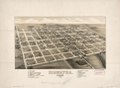 Hiawatha, Kansas, 1879 LOC 2013591257.tif 7,139 × 5,294; 108.13 MB
-
 Pawnee Indian cessions (5). (Pawnee country in Nebraska after 1876).png 2,256 × 1,462; 7.09 MB


._(Pawnee_country_in_Nebraska_after_1876).png)